Earth's atmosphere consists mostly of nitrogen and oxygen. More solar energy is received by tropical regions than polar regions, and is redistributed by atmospheric and ocean circulation. Greenhouse gases also play an important role in regulating the surface temperature. A region's climate is not only determined by latitude, but also by elevation, and by proximity to moderating oceans, among other factors. Severe weather, such as tropical cyclones, thunderstorms, and heat waves, occurs in most areas and has a large impact on life. Earth's gravity interacts with other objects in space, especially the Sun and the Moon, which is Earth's only natural satellite. Earth orbits around the Sun in about 365.25 days. Earth's axis of rotation is tilted with respect to its orbital plane, producing seasons on Earth. The gravitational interaction between Earth and the Moon causes tides, stabilizes Earth's orientation on its axis, and gradually slows its rotation. Earth is the densest planet in the Solar System and the largest and most massive of the four rocky planets.
Earth's atmosphere consists mostly of nitrogen and oxygen. More solar energy is received by tropical regions than polar regions, and is redistributed by atmospheric and ocean circulation. Greenhouse gases also play an important role in regulating the surface temperature. A region's climate is not only determined by latitude, but also by elevation, and by proximity to moderating oceans, among other factors. Severe weather, such as tropical cyclones, thunderstorms, and heat waves, occurs in most areas and has a large impact on life. Earth's gravity interacts with other objects in space, especially the Sun and the Moon, which is Earth's only natural satellite. Earth orbits around the Sun in about 365.25 days. Earth's axis of rotation is tilted with respect to its orbital plane, producing seasons on Earth. The gravitational interaction between Earth and the Moon causes tides, stabilizes Earth's orientation on its axis, and gradually slows its rotation. Earth is the densest planet in the Solar System and the largest and most massive of the four rocky planets.
−
According to radiometric dating estimation and other evidence, Earth formed over 4.543 billion years ago. Within the first billion years of Earth's history, life appeared in the oceans and began to affect Earth's atmosphere and surface, leading to the proliferation of anaerobic and, later, aerobic organisms. Some geological evidence indicates that life may have arisen as early as 4.1 billion years ago. Since then, the combination of Earth's distance from the Sun, physical properties and geological history have allowed life to evolve and thrive. In the history of life on Earth, biodiversity has gone through long periods of expansion, occasionally punctuated by mass extinctions. About 99% of all species that ever lived on Earth are extinct, since the very first lifeforms to us, humans, right now. Almost 7.6 billion people live on Earth and depend on its biosphere and natural resources for their survival. Humans increasingly impact Earth's surface, hydrology, atmospheric processes and other life. Humans will likely reach 9-10 billion in 2050 and maybe 10-11 billion later on.
+
According to radiometric dating estimation and other evidence, Earth formed over 4.543 billion years ago. Within the first billion years of Earth's history, life appeared in the oceans and began to affect Earth's atmosphere and surface, leading to the proliferation of anaerobic and, later, aerobic organisms. Some geological evidence indicates that life may have arisen as early as 4.1 billion years ago. Since then, the combination of Earth's distance from the Sun, physical properties and geological history have allowed life to evolve and thrive. In the history of life on Earth, biodiversity has gone through long periods of expansion, occasionally punctuated by mass extinctions. About 99% of all species that ever lived on Earth are extinct, since the very first lifeforms to us, humans, right now. Almost 7.6 billion people live on Earth and depend on its biosphere and natural resources for their survival. Humans increasingly impact Earth's surface, hydrology, atmospheric processes and other life. Humans will likely reach 9-10 billion in 2050 and maybe 10-11 billion later on.[[File:File-20210301-12-pyj8jo.webp|thumb|310x310px|The most beautiful planet]]
−
Earth is also the fifth largest planet and the densest of all the planets, with a density of 5.51 g/cm³. It is also the largest and most massive of all the rocky, inner planets. The masses of Mercury, Venus and Mars, all combined in 1 mass, make about 98% of the total mass of Earth.[[File:File-20210301-12-pyj8jo.webp|thumb|310x310px|The most beautiful planet]]
+
Earth is also the fifth largest planet and the densest of all the planets, with a density of 5.51 g/cm³. It is also the largest and most massive of all the rocky, inner planets. The masses of Mercury, Venus and Mars, all combined in 1 mass, make about 98% of the total mass of Earth.
== Flat Earth, Biblical Cosmology ==
== Flat Earth, Biblical Cosmology ==
[[File:Orlando-Ferguson-flat-earth-map edit.jpg|thumb|308x308px|Flat Earth map drawn by Orlando Ferguson in 1893. The map contains several references to biblical passages as well as various jabs at the "Globe Theory".]]
[[File:Orlando-Ferguson-flat-earth-map edit.jpg|thumb|308x308px|Flat Earth map drawn by Orlando Ferguson in 1893. The map contains several references to biblical passages as well as various jabs at the "Globe Theory".]]
Revision as of 19:17, 6 June 2021
Earth is the third planet from the Sun and the fifth largest planet in the Solar System. It is the only planet known to have a Moon which is unsurprisingly called ''The Moon'' as it was the first moon discovered and named. Earth the best known, most studied and most understood object in our Universe and has been here since our very first ancestors looked at the world around them and at the landscapes. Earth is named after ground. Lifeforms on earth are sometimes called terrestrial lifeforms. Earth orbits around the Sun. Earth is one of the smallest planets in the solar system, being only 12.75 megameters in length. It is one of the inner rocky planets, the largest of the four, but also very small compared to Jupiter, Saturn, Uranus and Neptune. It orbits next to Mars (further from the Sun) and Venus (closer to the Sun).
About 29,2% of Earth's surface is land consisting of continents and islands. The remaining 70.8% is covered with water, mostly by oceans, seas, gulfs, and other salt water bodies, but also by lakes, rivers, and other fresh water, which together constitute the hydrosphere. Much of Earth's polar regions are covered in ice. Earth's outer layer is divided into several rigid tectonic plates that migrate across the surface over many millions of years. Earth's interior remains active with a solid iron inner core, a liquid outer core that generates Earth's magnetic field, and a convecting mantle that drives plate tectonics. Rivers flow from mountains.
Earth's atmosphere consists mostly of nitrogen and oxygen. More solar energy is received by tropical regions than polar regions, and is redistributed by atmospheric and ocean circulation. Greenhouse gases also play an important role in regulating the surface temperature. A region's climate is not only determined by latitude, but also by elevation, and by proximity to moderating oceans, among other factors. Severe weather, such as tropical cyclones, thunderstorms, and heat waves, occurs in most areas and has a large impact on life. Earth's gravity interacts with other objects in space, especially the Sun and the Moon, which is Earth's only natural satellite. Earth orbits around the Sun in about 365.25 days. Earth's axis of rotation is tilted with respect to its orbital plane, producing seasons on Earth. The gravitational interaction between Earth and the Moon causes tides, stabilizes Earth's orientation on its axis, and gradually slows its rotation. Earth is the densest planet in the Solar System and the largest and most massive of the four rocky planets.
According to radiometric dating estimation and other evidence, Earth formed over 4.543 billion years ago. Within the first billion years of Earth's history, life appeared in the oceans and began to affect Earth's atmosphere and surface, leading to the proliferation of anaerobic and, later, aerobic organisms. Some geological evidence indicates that life may have arisen as early as 4.1 billion years ago. Since then, the combination of Earth's distance from the Sun, physical properties and geological history have allowed life to evolve and thrive. In the history of life on Earth, biodiversity has gone through long periods of expansion, occasionally punctuated by mass extinctions. About 99% of all species that ever lived on Earth are extinct, since the very first lifeforms to us, humans, right now. Almost 7.6 billion people live on Earth and depend on its biosphere and natural resources for their survival. Humans increasingly impact Earth's surface, hydrology, atmospheric processes and other life. Humans will likely reach 9-10 billion in 2050 and maybe 10-11 billion later on.
The most beautiful planet
Earth is also the fifth largest planet and the densest of all the planets, with a density of 5.51 g/cm³. It is also the largest and most massive of all the rocky, inner planets. The masses of Mercury, Venus and Mars, all combined in 1 mass, make about 98% of the total mass of Earth.
Flat Earth map drawn by Orlando Ferguson in 1893. The map contains several references to biblical passages as well as various jabs at the "Globe Theory".
Biblical Cosmology shows a Flat Earth.
Azimuthal equidistant projections of the sphere like this one have also been co-opted as images of the flat Earth model depicting Antarctica as an ice wall surrounding a disk-shaped Earth.
The flat Earth model is an archaic conception of Earth's shape as a plane or disk. Many ancient cultures subscribed to a flat Earth cosmography, including Greece until the classical period (323 BC), the Bronze Age and Iron Age civilizations of the Near East until the Hellenistic period (31 BC), India until the Gupta period (early centuries AD), and China until the 17th century. The idea of a spherical Earth appeared in ancient Greek philosophy with Pythagoras (6th century BC), although most pre-Socratics (6th–5th century BC) retained the flat Earth model. In the early 4th century BC Plato wrote about a spherical Earth, and by about 330 BC his former student, Aristotle, had provided strong empirical evidence for this. Knowledge of the Earth's global shape then gradually began to spread beyond the Hellenistic world. Despite the scientific fact of Earth's sphericity, pseudoscientific flat Earth conspiracy theories are espoused by modern flat Earth societies and, increasingly, by unaffiliated individuals using social media. The Hebrew Bible depicted a three-part world, with the heavens (shamayim) above, Earth (eres) in the middle, and the underworld (sheol) below. After the 4th century BCE this was gradually replaced by a Greek scientific cosmology of a spherical earth surrounded by multiple concentric heavens. The three-part world of heavens, Earth and underworld floated in Tehom, the mythological cosmic ocean, which covered the Earth until God created the firmament to divide it into upper and lower portions and reveal the dry land; the world has been protected from the cosmic ocean ever since by the solid dome of the firmament. The tehom is, or was, hostile to God: it confronted him at the beginning of the world (Psalm 104:6ff) but fled from the dry land at his rebuke; he has now set a boundary or bar for it which it can no longer pass (Jeremiah 5:22 and Job 38:8–10). The cosmic sea is the home of monsters which God conquers: "By his power he stilled the sea, by his understanding he smote Rahab!" (Job 26:12f). (Rahab is an exclusively Hebrew sea-monster; others, including Leviathan and the tannin, or dragons, are found in Ugaritic texts; it is not entirely clear whether they are identical with Sea or are Sea's helpers). The "bronze sea" which stood in the forecourt of the Temple in Jerusalem probably corresponds to the "sea" in Babylonian temples, representing the apsu, the cosmic ocean. In the New Testament Jesus' conquest of the stormy sea shows the conquering deity overwhelming the forces of chaos: a mere word of command from the Son of God stills the foe (Mark 4:35–41), who then tramples over his enemy, (Jesus walking on water - Mark 6:45, 47–51). In Revelation, where the Archangel Michael expels the dragon (Satan) from heaven ("And war broke out in heaven, with Michael and his angels attacking the dragon..." – Revelation 12:7), the motif can be traced back to Leviathan in Israel and to Tiamat, the chaos-ocean, in Babylonian myth, identified with Satan via an interpretation of the serpent in Eden. Flat earth is not real.
Belief in flat Earth
West Asia
In early Egyptian and Mesopotamian thought, the world was portrayed as a disk floating in the ocean. A similar model is found in the Homeric account from the 8th century BC in which "Okeanos, the personified body of water surrounding the circular surface of the Earth, is the begetter of all life and possibly of all gods." The Pyramid Texts and Coffin Texts of ancient Egypt show a similar cosmography; Nun (the Ocean) encircled nbwt ("dry lands" or "Islands").The Israelites also imagined the Earth to be a disc floating on water with an arched firmament above it that separated the Earth from the heavens. The sky was a solid dome with the Sun, Moon, planets, and stars embedded in it.
Greece
Poets
Possible rendering of Anaximander's world map.
Both Homer and Hesiod described a disc cosmography on the Shield of Achilles. This poetic tradition of an Earth-encircling (gaiaokhos) sea (Oceanus) and a disc also appears in Stasinus of Cyprus, Mimnermus, Aeschylus, and Apollonius Rhodius. Homer's description of the disc cosmography on the shield of Achilles with the encircling ocean is repeated far later in Quintus Smyrnaeus' Posthomerica (4th century AD), which continues the narration of the Trojan War.
Philosophers
Several pre-Socratic philosophers believed that the world was flat: Thales (c. 550 BC) according to several sources, and Leucippus (c. 440 BC) and Democritus (c. 460–370 BC) according to Aristotle.Thales thought that the Earth floated in water like a log. It has been argued, however, that Thales actually believed in a round Earth. Anaximander (c. 550 BC) believed that the Earth was a short cylinder with a flat, circular top that remained stable because it was the same distance from all things. Anaximenes of Miletus believed that "the Earth is flat and rides on air; in the same way the Sun and the Moon and the other heavenly bodies, which are all fiery, ride the air because of their flatness". Xenophanes of Colophon (c. 500 BC) thought that the Earth was flat, with its upper side touching the air, and the lower side extending without limit. Belief in a flat Earth continued into the 5th century BC. Anaxagoras (c. 450 BC) agreed that the Earth was flat, and his pupil Archelaus believed that the flat Earth was depressed in the middle like a saucer, to allow for the fact that the Sun does not rise and set at the same time for everyone.
Historians
Hecataeus of Miletus believed that the Earth was flat and surrounded by water. Herodotus in his Histories ridiculed the belief that water encircled the world, yet most classicists agree that he still believed Earth was flat because of his descriptions of literal "ends" or "edges" of the Earth.
Northern Europe
The ancient Norse and Germanic peoples believed in a flat Earth cosmography with the Earth surrounded by an ocean, with the axis mundi, a world tree (Yggdrasil), or pillar (Irminsul) in the centre. In the world-encircling ocean sat a snake called Jormungandr. The Norse creation account preserved in Gylfaginning (VIII) states that during the creation of the Earth, an impassable sea was placed around it: The late Norse Konungs skuggsjá, on the other hand, explains Earth's shape as a sphere:
East Asia
Illustration based on that of a 12th-century Asian cosmographer.
In ancient China, the prevailing belief was that the Earth was flat and square, while the heavens were round, an assumption virtually unquestioned until the introduction of European astronomy in the 17th century. The English sinologist Cullen emphasizes the point that there was no concept of a round Earth in ancient Chinese astronomy: The term flat-earth-man, used in a derogatory sense to mean anyone who holds ridiculously antiquated or impossible views, predates the more compact flat-earther. It was recorded in 1908: "Fewer votes than one would have thought possible for any human candidate, were he even a flat-earth-man." According to the Oxford English Dictionaryflat-Earther's first use is in 1934 in Punch magazine: "Without being a bigoted flat-earther, [Mercator] perceived the nuisance ... of fiddling about with globes ... in order to discover the South Seas."
The model of an egg was often used by Chinese astronomers such as Zhang Heng (78–139 AD) to describe the heavens as spherical: This analogy with a curved egg led some modern historians, notably Joseph Needham, to conjecture that Chinese astronomers were, after all, aware of the Earth's sphericity. The egg reference, however, was rather meant to clarify the relative position of the flat Earth to the heavens: Further examples cited by Needham supposed to demonstrate dissenting voices from the ancient Chinese consensus actually refer without exception to the Earth being square, not to it being flat. Accordingly, the 13th-century scholar Li Ye, who argued that the movements of the round heaven would be hindered by a square Earth, did not advocate a spherical Earth, but rather that its edge should be rounded off so as to be circular. However, Needham disagrees, affirming that Li Ye believed the Earth to be spherical, similar in shape to the heavens but much smaller. This was preconceived by the 4th-century scholar Yu Xi, who argued for the infinity of outer space surrounding the Earth and that the latter could be either square or round, in accordance to the shape of the heavens. When Chinese geographers of the 17th century, influenced by European cartography and astronomy, showed the Earth as a sphere that could be circumnavigated by sailing around the globe, they did so with formulaic terminology previously used by Zhang Heng to describe the spherical shape of the Sun and Moon (i.e. that they were as round as a crossbow bullet). As noted in the book Huainanzi, in the 2nd century BC, Chinese astronomers effectively inverted Eratosthenes' calculation of the curvature of the Earth to calculate the height of the Sun above the Earth. By assuming the Earth was flat, they arrived at a distance of 100000 li (approximately 200000 km). The Zhoubi Suanjing also discusses how to determine the distance of the Sun by measuring the length of noontime shadows at different latitudes, a method similar to Eratosthenes' measurement of the circumference of the Earth, but the Zhoubi Suanjing assumes that Earth is flat. These people are all wrong, because earth is not flat.
Alternate or mixed theories
Greece: spherical Earth
Pythagoras in the 6th century BC and Parmenides in the 5th century stated that the Earth is spherical, and this view spread rapidly in the Greek world. Around 330 BC, Aristotle maintained on the basis of physical theory and observational evidence that the Earth was spherical, and reported an estimate of its circumference. The Earth's circumference was first determined around 240 BC by Eratosthenes. By the 2nd century AD, Ptolemy had derived his maps from a globe and developed the system of latitude, longitude, and climes. His Almagest was written in Greek and only translated into Latin in the 11th century from Arabic translations. Lucretius (1st century BC) opposed the concept of a spherical Earth, because he considered that an infinite universe had no center towards which heavy bodies would tend. Thus, he thought the idea of animals walking around topsy-turvy under the Earth was absurd. By the 1st century AD, Pliny the Elder was in a position to claim that everyone agreed on the spherical shape of Earth, though disputes continued regarding the nature of the antipodes, and how it is possible to keep the ocean in a curved shape.
South Asia
The Vedic texts depict the cosmos in many ways. One of the earliest Indian cosmological texts picture the Earth as one of a stack of flat disks. In the Vedic texts, Dyaus (heaven) and Prithvi (Earth) are compared to wheels on an axle, yielding a flat model. They are also described as bowls or leather bags, yielding a concave model. According to Macdonell: "the conception of the Earth being a disc surrounded by an ocean does not appear in the Samhitas. But it was naturally regarded as circular, being compared with a wheel (10.89) and expressly called circular (parimandala) in the Shatapatha Brahmana."By about the 5th century CE, the siddhanta astronomy texts of South Asia, particularly of Aryabhata, assume a spherical Earth as they develop mathematical methods for quantitative astronomy for calendar and time keeping. The medieval Indian texts called the Puranas describe the Earth as a flat-bottomed, circular disk with concentric oceans and continents. This general scheme is present not only in the Hindu cosmologies, but also in Buddhist and Jain cosmologies of South Asia. However, some Puranas include other models. For example, the fifth canto of the Bhagavata Purana, includes sections that describe the Earth both as flat and spherical.
Early Christian Church
During the early period of the Christian Church, the spherical view continued to be widely held, with some notable exceptions. Athenagoras, an eastern Christian writing around the year 175 CE, said that the Earth was spherical. Methodius (c. 290 AD), an eastern Christian writing against "the theory of the Chaldeans and the Egyptians" said: "Let us first lay bare ... the theory of the Chaldeans and the Egyptians. They say that the circumference of the universe is likened to the turnings of a well-rounded globe, the Earth being a central point. They say that since its outline is spherical, ... the Earth should be the center of the universe, around which the heaven is whirling." Lactantius, a western Christian writer and advisor to the first Christian Roman Emperor, Constantine, writing sometime between 304–313 CE, ridiculed the notion of antipodes and the philosophers who fancied that "the universe is round like a ball. They also thought that heaven revolves in accordance with the motion of the heavenly bodies. ... For that reason, they constructed brass globes, as though after the figure of the universe." Arnobius, another eastern Christian writing sometime around 305 CE, described the round Earth: "In the first place, indeed, the world itself is neither right nor left. It has neither upper nor lower regions, nor front nor back. For whatever is round and bounded on every side by the circumference of a solid sphere, has no beginning or end ..."
The influential theologian and philosopher Saint Augustine, one of the four Great Church Fathers of the Western Church, similarly objected to the "fable" of antipodes:Some historians do not view Augustine's scriptural commentaries as endorsing any particular cosmological model, but while the view that Augustine shared the common view of his contemporaries that the Earth is spherical, in line with his endorsement of science in De Genesi ad litteram, is still occasionally challenged, most scholars agree that "Augustine’s acceptance of the earth’s spherical shape [is] a well-established fact".
Diodorus of Tarsus, a leading figure in the School of Antioch and mentor of John Chrysostom, may have argued for a flat Earth; however, Diodorus' opinion on the matter is known only from a later criticism. Chrysostom, one of the four Great Church Fathers of the Eastern Church and Archbishop of Constantinople, explicitly espoused the idea, based on scripture, that the Earth floats miraculously on the water beneath the firmament. Athanasius the Great, Church Father and Patriarch of Alexandria, expressed a similar view in Against the Heathen.
Christian Topography (547) by the Alexandrian monk Cosmas Indicopleustes, who had traveled as far as Sri Lanka and the source of the Blue Nile, is now widely considered the most valuable geographical document of the early medieval age, although it received relatively little attention from contemporaries. In it, the author repeatedly expounds the doctrine that the universe consists of only two places, the Earth below the firmament and heaven above it. Carefully drawing on arguments from scripture, he describes the Earth as a rectangle, 400 days' journey long by 200 wide, surrounded by four oceans and enclosed by four massive walls which support the firmament. The spherical Earth theory is contemptuously dismissed as "pagan".
Europe: Early Middle Ages
Early medieval Christian writers in the early Middle Ages felt little urge to assume flatness of the Earth, though they had fuzzy impressions of the writings of Ptolemy and Aristotle, relying more on Pliny. With the end of the Western Roman Empire, Western Europe entered the Middle Ages with great difficulties that affected the continent's intellectual production. Most scientific treatises of classical antiquity (in Greek) were unavailable, leaving only simplified summaries and compilations. In contrast, the Eastern Roman Empire did not fall, and it preserved the learning. Still, many textbooks of the Early Middle Ages supported the sphericity of the Earth in the western part of Europe.
Bishop Isidore of Seville (560–636) taught in his widely read encyclopedia, the Etymologies, diverse views such as that the Earth "resembles a wheel" resembling Anaximander in language and the map that he provided. This was widely interpreted as referring to a disc-shaped Earth. An illustration from Isidore's De Natura Rerum shows the five zones of the Earth as adjacent circles. Some have concluded that he thought the Arctic and Antarctic zones were adjacent to each other. He did not admit the possibility of antipodes, which he took to mean people dwelling on the opposite side of the Earth, considering them legendary and noting that there was no evidence for their existence. Isidore's T and O map, which was seen as representing a small part of a spherical Earth, continued to be used by authors through the Middle Ages, e.g. the 9th-century bishop Rabanus Maurus, who compared the habitable part of the northern hemisphere (Aristotle's northern temperate clime) with a wheel. At the same time, Isidore's works also gave the views of sphericity, for example, in chapter 28 of De Natura Rerum, Isidore claims that the Sun orbits the Earth and illuminates the other side when it is night on this side. See French translation of De Natura Rerum. In his other work Etymologies, there are also affirmations that the sphere of the sky has Earth in its center and the sky being equally distant on all sides. Other researchers have argued these points as well. "The work remained unsurpassed until the thirteenth century and was regarded as the summit of all knowledge. It became an essential part of European medieval culture. Soon after the invention of typography it appeared many times in print." However, "The Scholastics – later medieval philosophers, theologians, and scientists – were helped by the Arabic translators and commentaries, but they hardly needed to struggle against a flat-Earth legacy from the early middle ages (500–1050). Early medieval writers often had fuzzy and imprecise impressions of both Ptolemy and Aristotle and relied more on Pliny, but they felt (with one exception), little urge to assume flatness."St Vergilius of Salzburg (c. 700–784), in the middle of the 8th century, discussed or taught some geographical or cosmographical ideas that St Boniface found sufficiently objectionable that he complained about them to Pope Zachary. The only surviving record of the incident is contained in Zachary's reply, dated 748, where he wrote: Some authorities have suggested that the sphericity of the Earth was among the aspects of Vergilius's teachings that Boniface and Zachary considered objectionable. Others have considered this unlikely, and take the wording of Zachary's response to indicate at most an objection to belief in the existence of humans living in the antipodes. In any case, there is no record of any further action having been taken against Vergilius. He was later appointed bishop of Salzburg and was canonised in the 13th century. A possible non-literary but graphic indication that people in the Middle Ages believed that the Earth (or perhaps the world) was a sphere is the use of the orb (globus cruciger) in the regalia of many kingdoms and of the Holy Roman Empire. It is attested from the time of the Christian late-Roman emperor Theodosius II (423) throughout the Middle Ages; the Reichsapfel was used in 1191 at the coronation of emperor Henry VI. However the word orbis means "circle", and there is no record of a globe as a representation of the Earth since ancient times in the west until that of Martin Behaim in 1492. Additionally it could well be a representation of the entire "world" or cosmos. A recent study of medieval concepts of the sphericity of the Earth noted that "since the eighth century, no cosmographer worthy of note has called into question the sphericity of the Earth". However, the work of these intellectuals may not have had significant influence on public opinion, and it is difficult to tell what the wider population may have thought of the shape of the Earth, if they considered the question at all.
Europe: Late Middle Ages
Hermannus Contractus (1013–1054) was among the earliest Christian scholars to estimate the circumference of Earth with Eratosthenes' method. St. Thomas Aquinas (1225–1274), the most widely taught theologian of the Middle Ages, believed in a spherical Earth; and he even took for granted his readers also knew the Earth is round. Lectures in the medieval universities commonly advanced evidence in favor of the idea that the Earth was a sphere. Tattersall shows that in many vernacular works in 12th- and 13th-century French texts the Earth was considered "round like a table" rather than "round like an apple". "In virtually all the examples quoted ... from epics and from non-'historical' romances (that is, works of a less learned character) the actual form of words used suggests strongly a circle rather than a sphere", though he notes that even in these works the language is ambiguous. Portuguese navigation down and around the coast of Africa in the latter half of the 1400s gave wide-scale observational evidence for Earth's sphericity. In these explorations, the Sun position moved more northward the further south the explorers travelled. Its position directly overhead at noon gave evidence for crossing the equator. These apparent solar motions in detail were more consistent with north–south curvature and a distant Sun, than with any flat-Earth explanation. The ultimate demonstration came when Ferdinand Magellan's expedition completed the first global circumnavigation in 1521. Antonio Pigafetta, one of the few survivors of the voyage, recorded the loss of a day in the course of the voyage, giving evidence for east–west curvature.
Middle East: Islamic scholars
The Abbasid Caliphate saw a great flowering of astronomy and mathematics in the 9th century AD. Muslim scholars of the past believed in a spherical Earth. The Quran mentions that the Earth (al-arḍ) was "spread out". To this 12th-century commentary, the Tafsir al-Kabir (al-Razi) by Fakhr al-Din al-Razi states: "If it is said: Do the words 'And the Earth We spread out' indicate that it is flat? We would respond: Yes, because the Earth, even though it is round, is an enormous sphere, and each little part of this enormous sphere, when it is looked at, appears to be flat. As that is the case, this will dispel what they mentioned of confusion. The evidence for that is the verse in which Allah says (interpretation of the meaning): 'And the mountains as pegs' [an-Naba' 78:7]. He called them awtaad (pegs) even though these mountains may have large flat surfaces. And the same is true in this case."The 11th-century scholar Ibn Hazm stated: "Evidence shows that the Earth is a sphere but public people say the opposite." He added: "None of those who deserve being Imams for Muslims has denied that Earth is round. And we have not received anything indicates a denial, not even a single word."The 13th-century scholar Ibn Taymiyyah stated that the Earth is spherical and not flat. He stated that the Arabic word falak (Arabic: فَلَكٍ) refers to that which is round. The word is used in Quran 21:33 and Quran 36:40 to say that the sun and moon, night and day, each float in a falak. Unlike the previous scholars, scholar Al-Suyuti (d. 1505 CE) stated that the Earth is flat in his commentary on Quran 88:20, which he said was the opinion of the scholars of the law.
Ming Dynasty in China
A spherical terrestrial globe was introduced to Yuan-era Khanbaliq (i.e. Beijing) in 1267 by the Persian astronomer Jamal ad-Din, but it is not known to have made an impact on the traditional Chinese conception of the shape of the Earth. As late as 1595, an early Jesuit missionary to China, Matteo Ricci, recorded that the Ming-dynasty Chinese say: "The Earth is flat and square, and the sky is a round canopy; they did not succeed in conceiving the possibility of the antipodes."In the 17th century, the idea of a spherical Earth spread in China due to the influence of the Jesuits, who held high positions as astronomers at the imperial court. Matteo Ricci, in collaboration with Chinese cartographers and translator Li Zhizao, published the Kunyu Wanguo Quantu in 1602, the first Chinese world map based on European discoveries. The astronomical and geographical treatise Gezhicao (格致草) written in 1648 by Xiong Mingyu (熊明遇) explained that the Earth was spherical, not flat or square, and could be circumnavigated.
Myth of flat-Earth prevalence
Beginning in the 19th century, a historical myth arose which held that the predominant cosmological doctrine during the Middle Ages was that the Earth was flat. An early proponent of this myth was the American writer Washington Irving, who maintained that Christopher Columbus had to overcome the opposition of churchmen to gain sponsorship for his voyage of exploration. Later significant advocates of this view were John William Draper and Andrew Dickson White, who used it as a major element in their advocacy of the thesis that there was a long-lasting and essential conflict between science and religion. Some studies of the historical connections between science and religion have demonstrated that theories of their mutual antagonism ignore examples of their mutual support. Subsequent studies of medieval science have shown that most scholars in the Middle Ages, including those read by Christopher Columbus, maintained that the Earth was spherical.
In the modern era, the pseudoscientific belief in a flat Earth has been expressed by a variety of individuals and groups:
English writer Samuel Rowbotham (1816–1885), writing under the pseudonym "Parallax", produced in 1849 a pamphlet "Zetetic Astronomy" arguing for a flat Earth and published results of many experiments that tested the curvatures of water over a long-drainage ditch, followed by another, called The inconsistency of Modern Astronomy and its Opposition to the Scripture. One of his supporters, John Hampden, lost a bet to Alfred Russel Wallace in the famous Bedford Level experiment, which attempted to prove it. In 1877, Hampden produced a book A New Manual of Biblical Cosmography. Rowbotham also produced studies that purported to show that the effects of ships disappearing below the horizon could be explained by the laws of perspective in relation to the human eye. In 1883, he founded Zetetic Societies in England and New York, to which he shipped a thousand copies of Zetetic Astronomy.
William Carpenter, a printer originally from Greenwich, was a supporter of Rowbotham. Carpenter published Theoretical Astronomy Examined and Exposed – Proving the Earth not a Globe in eight parts from 1864 under the name Common Sense. He later emigrated to Baltimore, where he published One Hundred Proofs the Earth is Not a Globe in 1885. He wrote: "There are rivers that flow for hundreds of miles towards the level of the sea without falling more than a few feet – notably, the Nile, which, in a thousand miles, falls but a foot. A level expanse of this extent is quite incompatible with the idea of the Earth's convexity. It is, therefore, a reasonable proof that Earth is not a globe", as well as: "If the Earth were a globe, a small model globe would be the very best – because the truest – thing for the navigator to take to sea with him. But such a thing as that is not known: with such a toy as a guide, the mariner would wreck his ship, of a certainty! This is a proof that Earth is not a globe."
John Jasper, an American slave turned prolific preacher, and friend of Carpenter's, echoed his friend's sentiments in his most famous sermon "The Sun do move", preached over 250 times, always by invitation. In a written account of his sermon, published in The Richmond Whig of March 19, 1878, Jasper says he would frequently cite the verse "I saw four angels standing on the four corners of the earth" and follow up by arguing: "So we are living on a four-cornered earth; then, my friends, will you tell me how in the name of God can an earth with four corners be round!" In the same article he argued: "if the earth is like others say, who hold a different theory, peopled on the other side, those people would be obliged to walk on the ground with their feet upward like flies on the ceiling of a room".
In Brockport, New York, in 1887, M. C. Flanders argued the case of a flat Earth for three nights against two scientific gentlemen defending sphericity. Five townsmen chosen as judges voted unanimously for a flat Earth at the end. The case was reported in the Brockport Democrat.
Joseph W. Holden of Maine, a former justice of the peace, gave numerous lectures in New England and lectured on flat-Earth theory at the Columbian Exposition in Chicago. His fame stretched to North Carolina, where the Statesville Semi-weekly Landmark recorded at his death in 1900: "We hold to the doctrine that the Earth is flat ourselves and we regret exceedingly to learn that one of our members is dead."
After Rowbotham's death, Lady Elizabeth Blount (Elizabeth de Sodington Blount, née Elizabeth Anne Mould Williams) created the Universal Zetetic Society in 1893 in England and created a journal called Earth not a Globe Review, which sold for twopence, as well as one called Earth, which only lasted from 1901 to 1904. She held that the Bible was the unquestionable authority on the natural world and argued that one could not be a Christian and believe the Earth is a globe. Well-known members included E. W. Bullinger of the Trinitarian Bible Society, Edward Haughton, senior moderator in natural science in Trinity College, Dublin and an archbishop. She repeated Rowbotham's experiments, generating some counter-experiments, but interest declined after the First World War. The movement gave rise to several books that argued for a flat, stationary Earth, including Terra Firma by David Wardlaw Scott.
In 1898, during his solo circumnavigation of the world, Joshua Slocum encountered a group of flat-Earthers in Durban, South Africa. Three Boers, one of them a clergyman, presented Slocum with a pamphlet in which they set out to prove that the world was flat. Paul Kruger, President of the Transvaal Republic, advanced the same view: "You don't mean round the world, it is impossible! You mean in the world. Impossible!"
From 1915 to 1942 Wilbur Glenn Voliva, who in 1906 took over the Christian Catholic Church, a Pentecostal sect that established a utopian community in Zion, Illinois, preached flat Earth doctrine. He used a photograph of a twelve-mile (19 km) stretch of the shoreline at Lake Winnebago, Wisconsin, taken three feet (91 cm) above the waterline to prove his point. When the airship Italia disappeared on an expedition to the North Pole in 1928, he warned the world's press that it had sailed over the edge of the world. He offered a $5000 award for proving that the Earth is not flat, under his own conditions. Teaching a globular Earth was banned in the Zion schools, and the message was transmitted on his WCBD radio station.
In 1956, Samuel Shenton set up the International Flat Earth Research Society (IFERS), better known as the Flat Earth Society from Dover, UK, as a direct descendant of the Universal Zetetic Society.
Along with those who followed him, Frank Cherry (died 1963), the founder of the Black Hebrew Israelite religion, taught the existence of a flat earth "surrounded by three layers of heaven."
In 2018, astronomer Yaël Nazé analyzed the controversy over a Ph.D. dissertation proposed by a student at the University of Sfax in Tunisia, which defended a flat Earth, as well as a geocentric model of the solar system and a young Earth. The dissertation, which had not been approved by the committee overseeing environmental studies theses, had been made public and denounced in 2017 by Hafedh Ateb, a founder of the Tunisian Astronomical Society on his Facebook page.
Flat Earth Society
The International Flat Earth Research Society (IFERS), better known as the Flat Earth Society, was set up by Samuel Shenton in 1956, in Dover, UK, as a direct descendant of the Universal Zetetic Society. This was just before the Soviet Union launched the first artificial satellite, Sputnik; he responded: "Would sailing round the Isle of Wight prove that it were spherical? It is just the same for those satellites."His primary aim was to reach children before they were convinced about a spherical Earth. Despite plenty of publicity, the space race eroded Shenton's support in Britain until 1967, when he started to become famous due to the Apollo program. In 1972, Shenton's role was taken over by Charles K. Johnson, a correspondent from California, US. He incorporated the IFERS and steadily built it up to about 3000 members. He spent years examining the studies of flat- and round-Earth theories and proposed evidence of a conspiracy against flat Earth: "The idea of a spinning globe is only a conspiracy of error that Moses, Columbus, and FDR all fought..." His article was published in the magazine Science Digest in 1980. It goes on to state: "If it is a sphere, the surface of a large body of water must be curved. The Johnsons have checked the surfaces of Lake Tahoe and the Salton Sea without detecting any curvature."The Society declined in the 1990s following a fire at its headquarters in California, and Johnson died in 2001. It was revived as a website in 2004 by Daniel Shenton (no relation to Samuel Shenton). He believes that no one has provided proof that the world is not flat.
Internet-era resurgence
In the Internet era, the proliferation of communications technology and social-media platforms such as YouTube, Facebook and Twitter have given individuals, famous or otherwise, a platform to spread pseudo-scientific ideas and build stronger followings. The flat-Earth conjecture has flourished in this environment. Social media and the internet, furthermore, have made it easier for like-minded theorists to connect with one another and mutually reinforce their beliefs. In other words, social media has had a "levelling effect", in that experts have less sway in the public mind than they used to. YouTube had faced criticism for allowing the spread of misinformation and conspiracy theories through its platform. In 2019, YouTube stated that it was making changes in its software to reduce the distribution of videos based on conspiracy theories including flat Earth.
Organizations skeptical of fringe beliefs have occasionally performed tests to demonstrate the local curvature of the Earth. One of these, conducted by members of the Independent Investigations Group at the Salton Sea on June 10, 2018, was attended also by supporters of a flat Earth, and the encounter between the two groups was recorded by the National Geographic Explorer. This experiment successfully demonstrated the curvature of the Earth by the disappearance over distance of boat-based and shore-based targets.
Conspiracy theory
An image of Thorntonbank Wind Farm (near the Belgian coast) with the lower parts of the more distant towers increasingly hidden by the horizon, demonstrating the curvature of Earth.
Members of the Flat Earth Society and other flat-Earthers claim that NASA and other government agencies conspire to fabricate evidence that the Earth is spherical. According to the most widely spread version of current flat-Earth theory, NASA is guarding the Antarctic ice wall that surrounds Earth. Flat-Earthers argue that NASA photoshops its satellite images, based on observations that the color of the oceans changes from image to image and that continents seem to be in different places. The publicly perpetuated image is kept up through a large-scale practice of "compartmentalization", according to which only a select number of individuals have knowledge about the truth.
Notes: Earth is round, the so-called firmament is just the night sky, heavens are much further and there is probably no such thing as a Tehom. These are scientifically proven facts. Earth is round and it makes perfect sense.
Etymology of Earth
The modern English word Earth developed, via Middle English, from an Old English noun most often spelled eorðe. It has cognates in every Germanic language, and their ancestral root has been reconstructed as *erþō. In its earliest attestation, the word eorðe was already being used to translate the many senses of Latin terra and Greek γῆ gē: the ground, its soil, dry land, the human world, the surface of the world (including the sea), and the globe itself. As with Roman Terra/Tellūs and Greek Gaia, Earth may have been a personified goddess in Germanic paganism: late Norse mythology included Jörð ('Earth'), a giantess often given as the mother of Thor.
Historically, earth has been written in lowercase. From early Middle English, its definite sense as "the globe" was expressed as the earth. By Early Modern English, many nouns were capitalized, and the earth was also written the Earth, particularly when referenced along with other heavenly bodies. More recently, the name is sometimes simply given as Earth, by analogy with the names of the other planets, though earth and forms with the remain common. House styles now vary: Oxford spelling recognizes the lowercase form as the most common, with the capitalized form an acceptable variant. Another convention capitalizes "Earth" when appearing as a name (for example, "Earth's atmosphere") but writes it in lowercase when preceded by the (for example, "the atmosphere of the earth"). It almost always appears in lowercase in colloquial expressions such as "what on earth are you doing?"
Occasionally, the name Terra /ˈtɛrə/ is used in scientific writing and especially in science fiction to distinguish humanity's inhabited planet from others, while in poetry Tellus /ˈtɛləs/ has been used to denote personification of the Earth. The Greek poetic name Gaia (Gæa) /ˈdʒiːə/ is rare, though the alternative spelling Gaia has become common due to the Gaia hypothesis, in which case its pronunciation is /ˈɡaɪə/ rather than the more Classical /ˈɡeɪə/. There are a number of adjectives for the planet Earth. From Earth itself comes earthly. From the Latin Terra comes terran /ˈtɛrən/, terrestrial /təˈrɛstriəl/, and (via French) terrene /təˈriːn/, and from the Latin Tellus comes tellurian /tɛˈlʊəriən/ and telluric.
Culture
Human cultures have developed many views of the planet. The standard astronomical symbol of Earth consists of a cross circumscribed by a circle, , representing the four corners of the world. Earth is sometimes personified as a deity. In many cultures it is a mother goddess that is also the primary fertility deity. Creation myths in many religions involve the creation of Earth by a supernatural deity or deities. The Gaia Principle, developed mid-20th century, compared Earth's environments and life as a single self-regulating organism leading to broad stabilization of the conditions of habitability. Images of Earth taken from space, particularly during the Apollo program, have been credited with altering the way that people viewed the planet that they lived on, emphasising its beauty, uniqueness and apparent fragility.
Scientific investigation has resulted in several culturally transformative shifts in people's view of the planet. Initial belief in a flat Earth was gradually displaced in Ancient Greece by the idea of a spherical Earth, which was attributed to both the philosophers Pythagoras and Parmenides. Earth was generally believed to be the center of the universe until the 16th century, when scientists first concluded that it was a moving object, comparable to the other planets in the Solar System.
It was only during the 19th century that geologists realized Earth's age was at least many millions of years. Lord Kelvin used thermodynamics to estimate the age of Earth to be between 20 million and 400 million years in 1864, sparking a vigorous debate on the subject; it was only when radioactivity and radioactive dating were discovered in the late 19th and early 20th centuries that a reliable mechanism for determining Earth's age was established, proving the planet to be billions of years old.
Human geography and population
The Human population has passed seven billion in the early 2010s, and is projected to peak at around ten billion in the second half of the 21st century. Most of the growth is expected to take place in sub-Saharan Africa. Human population density varies widely around the world, but a majority live in Asia. By 2050, 68% of the world's population is expected to be living in urban, rather than rural, areas. 68% of the land mass of the world is in the Northern Hemisphere. Partly due to the predominance of land mass, 90% of humans live in the Northern Hemisphere.
It is estimated that one-eighth of Earth's surface is suitable for humans to live on—three-quarters of Earth's surface is covered by oceans, leaving one-quarter as land. Half of that land area is desert (14%), high mountains (27%), or other unsuitable terrains. States claim the planet's entire land surface, except for parts of Antarctica and a few other unclaimed areas. Earth has never had a planetwide government, but the United Nations is the leading worldwide intergovernmental organization.
The first human to orbit Earth was Yuri Gagarin on 12 April 1961. In total, about 550 people have visited outer space and reached orbit as of November 2018, and, of these, twelve have walked on the Moon. Normally, the only humans in space are those on the International Space Station. The station's crew, made up of six people, is usually replaced every six months. The farthest that humans have traveled from Earth is 400,171 km (248,655 mi), achieved during the Apollo 13 mission in 1970. The first person to walk on the moon was Neil Armstrong.
Origins and History
The history of Earth concerns the development of planet Earth from its formation to the present day. Nearly all branches of natural science have contributed to understanding of the main events of Earth's past, characterized by constant geological change and biological evolution.
Geological History of Earth
The geological time scale (GTS), as defined by international convention, depicts the large spans of time from the beginning of the Earth to the present, and its divisions chronicle some definitive events of Earth history. (In the graphic: Ga means "billion years ago"; Ma, "million years ago".) Earth formed around 4.54 billion years ago, approximately one-third the age of the universe, by accretion from the solar nebula. Volcanic outgassing probably created the primordial atmosphere and then the ocean, but the early atmosphere contained almost no oxygen. Much of the Earth was molten because of frequent collisions with other bodies which led to extreme volcanism. While the Earth was in its earliest stage (Early Earth), a giant impact collision with a planet-sized body named Theia is thought to have formed the Moon. Over time, the Earth cooled, causing the formation of a solid crust, and allowing liquid water on the surface.
The Hadean eon represents the time before a reliable (fossil) record of life; it began with the formation of the planet and ended 4.0 billion years ago. The following Archean and Proterozoic eons produced the beginnings of life on Earth and its earliest evolution. The succeeding eon is the Phanerozoic, divided into three eras: the Palaeozoic, an era of arthropods, fishes, and the first life on land; the Mesozoic, which spanned the rise, reign, and climactic extinction of the non-avian dinosaurs; and the Cenozoic, which saw the rise of mammals. Recognizable humans emerged at most 2 million years ago, a vanishingly small period on the geological scale.
The earliest undisputed evidence of life on Earth dates at least from 3.5 billion years ago, during the Eoarchean Era, after a geological crust started to solidify following the earlier molten Hadean Eon. There are microbial mat fossils such as stromatolites found in 3.48 billion-year-old sandstone discovered in Western Australia. Other early physical evidence of a biogenic substance is graphite in 3.7 billion-year-old metasedimentary rocks discovered in southwestern Greenland as well as "remains of biotic life" found in 4.1 billion-year-old rocks in Western Australia. According to one of the researchers, "If life arose relatively quickly on Earth … then it could be common in the universe."
Photosynthetic organisms appeared between 3.2 and 2.4 billion years ago and began enriching the atmosphere with oxygen. Life remained mostly small and microscopic until about 580 million years ago, when complex multicellular life arose, developed over time, and culminated in the Cambrian Explosion about 541 million years ago. This sudden diversification of life forms produced most of the major phyla known today, and divided the Proterozoic Eon from the Cambrian Period of the Paleozoic Era. It is estimated that 99 percent of all species that ever lived on Earth, over five billion, have gone extinct. Estimates on the number of Earth's current species range from 10 million to 14 million, of which about 1.2 million are documented, but over 86 percent have not been described. However, it was recently claimed that 1 trillion species currently live on Earth, with only one-thousandth of one percent described.
The Earth's crust has constantly changed since its formation, as has life since its first appearance. Species continue to evolve, taking on new forms, splitting into daughter species, or going extinct in the face of ever-changing physical environments. The process of plate tectonics continues to shape the Earth's continents and oceans and the life they harbor. Human activity is now a dominant force affecting global change, harming the biosphere, the Earth's surface, hydrosphere, and atmosphere with the loss of wild lands, over-exploitation of the oceans, production of greenhouse gases, degradation of the ozone layer, and general degradation of soil, air, and water quality.
Origins of life and evolution
Chemical reactions led to the first self-replicating molecules about four billion years ago. A half billion years later, the last common ancestor of all current life arose. The evolution of photosynthesis allowed the Sun's energy to be harvested directly by life forms. The resultant molecular oxygen (O2) accumulated in the atmosphere and due to interaction with ultraviolet solar radiation, formed a protective ozone layer (O3) in the upper atmosphere. The incorporation of smaller cells within larger ones resulted in the development of complex cells called eukaryotes. True multicellular organisms formed as cells within colonies became increasingly specialized. Aided by the absorption of harmful ultraviolet radiation by the ozone layer, life colonized Earth's surface. Among the earliest fossil evidence for life is microbial mat fossils found in 3.48 billion-year-old sandstone in Western Australia, biogenic graphite found in 3.7 billion-year-old metasedimentary rocks in Western Greenland, and remains of biotic material found in 4.1 billion-year-old rocks in Western Australia. The earliest direct evidence of life on Earth is contained in 3.45 billion-year-old Australian rocks showing fossils of microorganisms.
During the Neoproterozoic, 1000 to 541 Ma, much of Earth might have been covered in ice. This hypothesis has been termed "Snowball Earth", and it is of particular interest because it preceded the Cambrian explosion, when multicellular life forms significantly increased in complexity. Following the Cambrian explosion, 535 Ma, there have been at least five major mass extinctions and many minor ones. Apart from the proposed current Holocene extinction event, the most recent was 66 Ma, when an asteroid impact triggered the extinction of the non-avian dinosaurs and other large reptiles, but largely spared small animals such as insects, mammals, lizards and birds. Mammalian life has diversified over the past 66 Mys, and several million years ago an African ape gained the ability to stand upright. This facilitated tool use and encouraged communication that provided the nutrition and stimulation needed for a larger brain, which led to the evolution of humans. The development of agriculture, and then civilization, led to humans having an influence on Earth and the nature and quantity of other life forms that continues to this day. Over 99% of all species that ever lived on Earth are extinct.
Ancient Earth and Geologic Eras
A geologic era is a subdivision of geologic time that divides an eon into smaller units of time. The Phanerozoic Eon is divided into three such time frames: the Paleozoic, Mesozoic, and Cenozoic (meaning "old life", "middle life" and "recent life") that represent the major stages in the macroscopic fossil record. These eras are separated by catastrophic extinction boundaries: the P-T boundary between the Paleozoic and the Mesozoic, and the K-Pg boundary between the Mesozoic and the Cenozoic. There is evidence that catastrophic meteorite impacts played a role in demarcating the differences between the eras. The Hadean, Archean and Proterozoic eons were as a whole formerly called the Precambrian. This covered the four billion years of Earth history prior to the appearance of hard-shelled animals. More recently, however, the Archean and Proterozoic eons have been subdivided into eras of their own.
Geologic eras are further subdivided into geologic periods, although the Archean eras have yet to be subdivided in this way.
List of geological eras in Earth's history
Eon
Era
Time frame (Ma = million years ago)
Phanerozoic
Cenozoic
66 million years ago to present
Mesozoic
251.902 to 66 million years ago
Paleozoic
541 to 251.902 million years ago
Proterozoic
Neoproterozoic
1,000 to 541 million years ago
Mesoproterozoic
1,600 to 1,000 million years ago
Paleoproterozoic
2,500 to 1,600 million years ago
Archean
Neoarchean
2,800 to 2,500 million years ago
Mesoarchean
3,200 to 2,800 million years ago
Paleoarchean
3,600 to 3,200 million years ago
Eoarchean
4,000 to 3,600 million years ago
Hadean
not officially divided into eras
Formation of Earth to 4,000 million years ago
Artistic impression of the Hadean eon.
The Hadean ( /ˈheɪdiən, heɪˈdiːən/ HAY-dee-ən, hay-DEE-ən) is a geologic eon of Earth history preceding the Archean. It began with the formation of the Earth about 4.6 billion years ago and ended, as defined by the International Commission on Stratigraphy (ICS), 4 billion years ago. As of 2016, the ICS describes its status as "informal". The term was coined after the Greek mythical underworld Hades, by American geologist Preston Cloud, originally to label the period before the earliest-known rocks on Earth. W. Brian Harland later coined an almost synonymous term, the Priscoan period, from priscus, the Latin word for 'ancient'. Other, older texts refer to the eon as the Pre-Archean. "Hadean" (from Hades, the Greek god of the underworld, and the underworld itself) describes the hellish conditions then prevailing on Earth: the planet had just formed and was still very hot owing to its recent accretion, the abundance of short-lived radioactive elements, and frequent collisions with other Solar System bodies.
Since few geological traces of this eon remain on Earth, there is no official subdivision. However, the Lunar geologic timescale embraces several major divisions relating to the Hadean, so these are sometimes used in an informal sense to refer to the same periods of time on Earth.
The Lunar divisions are:
Pre-Nectarian, from the formation of the Moon's crust (4,533 million years ago) up to about 3,920 million years ago.
Nectarian ranging from 3,920 million years ago up to about 3,850 million years ago, in a time when the Late Heavy Bombardment, according to that theory, was declining.
In 2010, an alternative scale was proposed that includes the addition of the Chaotian and Prenephelean Eons preceding the Hadean, and divides the Hadean into three eras with two periods each. The Paleohadean era consists of the Hephaestean (4.5–4.4 Ga) and the Jacobian periods (4.4–4.3 Ga). The Mesohadean is divided into the Canadian (4.3–4.2 Ga) and the Procrustean periods (4.2–4.1 Ga). The Neohadean is divided into the Acastan (4.1–4.0 Ga) and the Promethean periods (4.0–3.9 Ga). As of February 2017, this has not been adopted by the IUGS. In the last decades of the 20th-century geologists identified a few Hadean rocks from western Greenland, northwestern Canada, and Western Australia. In 2015, traces of carbon minerals interpreted as "remains of biotic life" were found in 4.1-billion-year-old rocks in Western Australia. The oldest dated zircon crystals, enclosed in a metamorphosed sandstone conglomerate in the Jack Hills of the Narryer Gneiss Terrane of Western Australia, date to 4.404 ± 0.008 Ga. This zircon is a slight outlier, with the oldest consistently-dated zircon falling closer to 4.35 Ga—around 200 million years after the hypothesized time of the Earth's formation. In many other areas, xenocryst (or relict) Hadean zircons enclosed in older rocks indicate that younger rocks have formed on older terranes and have incorporated some of the older material. One example occurs in the Guiana shield from the Iwokrama Formation of southern Guyana where zircon cores have been dated at 4.22 Ga. A sizable quantity of water would have been in the material that formed the Earth. Water molecules would have escaped Earth's gravity more easily when it was less massive during its formation. Hydrogen and helium are expected to continually escape (even to the present day) due to atmospheric escape.
Part of the ancient planet is theorized to have been disrupted by the impact that created the Moon, which should have caused melting of one or two large regions of the Earth. Earth's present composition suggests that there was not complete remelting as it is difficult to completely melt and mix huge rock masses. However, a fair fraction of material should have been vaporized by this impact, creating a rock vapor atmosphere around the young planet. The rock vapor would have condensed within two thousand years, leaving behind hot volatiles which probably resulted in a heavy CO2 atmosphere with hydrogen and water vapor. Liquid water oceans existed despite the surface temperature of 230 °C (446 °F) because at an atmospheric pressure of above 27 atmospheres, caused by the heavy CO2 atmosphere, water is still liquid. As cooling continued, subduction and dissolving in ocean water removed most CO2 from the atmosphere but levels oscillated wildly as new surface and mantle cycles appeared. Studies of zircons have found that liquid water must have existed as long ago as 4.4 billion years ago, very soon after the formation of the Earth. This requires the presence of an atmosphere. The cool early Earth theory covers a range from about 4.4 to about 4.1 billion years. A September 2008 study of zircons found that Australian Hadean rock holds minerals pointing to the existence of plate tectonics as early as 4 billion years ago (approximately 600 million years after Earth's formation). If this is true, the time when Earth finished its transition from having a hot, molten surface and atmosphere full of carbon dioxide, to being very much like it is today, can be roughly dated to about 4.0 billion years ago. The actions of plate tectonics and the oceans trapped vast amounts of carbon dioxide, thereby reducing the greenhouse effect and leading to a much cooler surface temperature and the formation of solid rock, and possibly even life.
Artistic impression of the Archean eon.
The Archean Eon ( /ɑːrˈkiːən/ ar-KEE-ən, also spelled Archaean or Archæan) is one of the four geologic eons of Earth's history, occurring 4,000 to 2,500 million years ago (4 to 2.5 Gya). During the Archean, the Earth's crust had cooled enough to allow the formation of continents and the beginning of life on Earth.
When the Archean began, the Earth's heat flow was nearly three times as high as it is today, and it was still twice the current level at the transition from the Archean to the Proterozoic (2,500 Ma). The extra heat was the result of a mix of remnant heat from planetary accretion, from the formation of the metallic core, and from the decay of radioactive elements.
Although a few mineral grains are known to be Hadean, the oldest rock formations exposed on the surface of the Earth are Archean. Archean rocks are found in Greenland, Siberia, the Canadian Shield, Montana and Wyoming (exposed parts of the Wyoming Craton), the Baltic Shield, the Rhodope Massif, Scotland, India, Brazil, western Australia, and southern Africa.[citation needed] Granitic rocks predominate throughout the crystalline remnants of the surviving Archean crust. Examples include great melt sheets and voluminous plutonic masses of granite, diorite, layered intrusions, anorthosites and monzonites known as sanukitoids. Archean rocks are often heavily metamorphized deep-water sediments, such as graywackes, mudstones, volcanic sediments, and banded iron formations. Volcanic activity was considerably higher than today, with numerous lava eruptions, including unusual types such as komatiite. Carbonate rocks are rare, indicating that the oceans were more acidic due to dissolved carbon dioxide than during the Proterozoic. Greenstone belts are typical Archean formations, consisting of alternating units of metamorphosed mafic igneous and sedimentary rocks, including Archean felsic volcanic rocks. The metamorphosed igneous rocks were derived from volcanic island arcs, while the metamorphosed sediments represent deep-sea sediments eroded from the neighboring island arcs and deposited in a forearc basin. Greenstone belts, being both types of metamorphosed rock, represent sutures between the protocontinents.
The Earth's continents started to form in the Archean, although details about their formation are still being debated, due to lack of extensive geological evidence. One hypothesis is that rocks that are now in India, western Australia, and southern Africa formed a continent called Ur as of 3,100 Ma. A differing conflicting hypothesis is that rocks from western Australia and southern Africa were assembled in a continent called Vaalbara as far back as 3,600 Ma. Although the first continents formed during this eon, rock of this age makes up only 7% of the present world's cratons; even allowing for erosion and destruction of past formations, evidence suggests that only 5–40% of the present area of continents formed during the Archean.
By the end of the Archean around 2500 Ma (2.5 Gya), plate tectonic activity may have been similar to that of the modern Earth. There are well-preserved sedimentary basins, and evidence of volcanic arcs, intracontinental rifts, continent-continent collisions and widespread globe-spanning orogenic events suggesting the assembly and destruction of one and perhaps several supercontinents. Evidence from banded iron formations, chert beds, chemical sediments and pillow basalts demonstrates that liquid water was prevalent and deep oceanic basins already existed.
The Archean atmosphere is thought to have nearly lacked free oxygen. Astronomers think that the Sun had about 70–75 percent of the present luminosity, yet temperatures on Earth appear to have been near modern levels after only 500 Ma of Earth's formation (the faint young Sun paradox). The presence of liquid water is evidenced by certain highly deformed gneisses produced by metamorphism of sedimentary protoliths. The moderate temperatures may reflect the presence of greater amounts of greenhouse gases than later in the Earth's history. Alternatively, Earth's albedo may have been lower at the time, due to less land area and cloud cover.
The processes that gave rise to life on Earth are not completely understood, but there is substantial evidence that life came into existence either near the end of the Hadean Eon or early in the Archean Eon. The earliest evidence for life on Earth are graphite of biogenic origin found in 3.7 billion-year-old metasedimentary rocks discovered in Western Greenland. The earliest identifiable fossils consist of stromatolites, which are microbial mats formed in shallow water by cyanobacteria. The earliest stromatolites are found in 3.48 billion-year-old sandstone discovered in Western Australia. Stromatolites are found throughout the Archean and become common late in the Archean. Cyanobacteria were instrumental in creating free oxygen in the atmosphere. Further evidence for early life is found in 3.47 billion-year-old baryte, in the Warrawoona Group of Western Australia. This mineral shows sulfur fractionation of as much as 21.1%, which is evidence of sulfate-reducing bacteria that metabolize sulfur-32 more readily than sulfur-34. Evidence of life in the Late Hadean is more controversial. In 2015, biogenic carbon was detected in zircons dated to 4.1 billion years ago, but this evidence is preliminary and needs validation. Earth was very hostile to life before 4.2–4.3 Ga and the conclusion is that before the Archean Eon, life as we know it would have been challenged by these environmental conditions. While life could have arisen before the Archean, the conditions necessary to sustain life could not have occurred until the Archean Eon. Life in the Archean was limited to simple single-celled organisms (lacking nuclei), called Prokaryota. In addition to the domain Bacteria, microfossils of the domain Archaea have also been identified. There are no known eukaryotic fossils from the earliest Archean, though they might have evolved during the Archean without leaving any. Fossil steranes, indicative of eukaryotes, have been reported from Archean strata but were shown to derive from contamination with younger organic matter. No fossil evidence has been discovered for ultramicroscopic intracellular replicators such as viruses. Fossilized microbes from terrestrial microbial mats show that life was already established on land 3.22 billion years ago.
The word 'Archean' comes from the ancient Greek word Αρχή ('Arkhē'), meaning 'beginning, origin.' It was first used in 1872, when it meant "of the earliest geological age." Before the Hadean Eon was recognized, the Archean spanned Earth's early history from its formation about 4,540 million years ago (Mya) until 2,500 Mya.[citation needed] Instead of being based on stratigraphy, the beginning and end of the Archean Eon are defined chronometrically. The eon's lower boundary or starting point of 4 Gya (4 billion years ago) is officially recognized by the International Commission on Stratigraphy.
Artist's depiction of life on the ocean floor as it may have appeared in the late Proterozoic.
The Proterozoic ( /ˌproʊtərəˈzoʊɪk, prɒt-, -əroʊ-, -trə-, -troʊ-/) is a geological eon spanning the time from the appearance of oxygen in Earth's atmosphere to just before the proliferation of complex life (such as trilobites or corals) on the Earth. The name Proterozoic combines the two forms of ultimately Greek origin: protero- meaning "former, earlier", and -zoic, a suffix related to zoe "life". The Proterozoic Eon extended from 2500 mya to 541 mya (million years ago), and is the most recent part of the Precambrian "supereon." The Proterozoic is the longest eon of the Earth's geologic time scale and it is subdivided into three geologic eras (from oldest to youngest): the Paleoproterozoic, Mesoproterozoic, and Neoproterozoic. The well-identified events of this eon were the transition to an oxygenated atmosphere during the Paleoproterozoic; several glaciations, which produced the hypothesized Snowball Earth during the Cryogenian Period in the late Neoproterozoic Era; and the Ediacaran Period (635 to 541 Ma) which is characterized by the evolution of abundant soft-bodied multicellular organisms and provides us with the first obvious fossil evidence of life on Earth.
The geologic record of the Proterozoic Eon is more complete than that for the preceding Archean Eon. In contrast to the deep-water deposits of the Archean, the Proterozoic features many strata that were laid down in extensive shallow epicontinental seas; furthermore, many of those rocks are less metamorphosed than there are Archean ones, and many are unaltered. Studies of these rocks have shown that the eon continued the massive continental accretion that had begun late in the Archean Eon. The Proterozoic Eon also featured the first definitive supercontinent cycles and wholly modern mountain building activity (orogeny). There is evidence that the first known glaciations occurred during the Proterozoic. The first began shortly after the beginning of the Proterozoic Eon, and evidence of at least four during the Neoproterozoic Era at the end of the Proterozoic Eon, possibly climaxing with the hypothesized Snowball Earth of the Sturtian and Marinoan glaciations. One of the most important events of the Proterozoic was the accumulation of oxygen in the Earth's atmosphere. Though oxygen is believed to have been released by photosynthesis as far back as Archean Eon, it could not build up to any significant degree until mineral sinks of unoxidized sulfur and iron had been exhausted. Until roughly 2.3 billion years ago, oxygen was probably only 1% to 2% of its current level. The Banded iron formations, which provide most of the world's iron ore, are one mark of that mineral sink process. Their accumulation ceased after 1.9 billion years ago, after the iron in the oceans had all been oxidized. Red beds, which are colored by hematite, indicate an increase in atmospheric oxygen 2 billion years ago. Such massive iron oxide formations are not found in older rocks. The oxygen buildup was probably due to two factors: exhaustion of the chemical sinks, and an increase in carbon burial, which sequestered organic compounds that would have otherwise been oxidized by the atmosphere.
The Proterozoic Eon was a very tectonically active period in the Earth's history. The late Archean Eon to Early Proterozoic Eon corresponds to a period of increasing crustal recycling, suggesting subduction. Evidence for this increased subduction activity comes from the abundance of old granites originating mostly after 2.6 Ga. The occurrence of eclogite (a type of metamorphic rock created by high pressure, > 1 GPa), is explained using a model that incorporates subduction. The lack of eclogites that date to the Archean Eon suggests that conditions at that time did not favor the formation of high grade metamorphism and therefore did not achieve the same levels of subduction as was occurring in the Proterozoic Eon. As a result of remelting of basaltic oceanic crust due to subduction, the cores of the first continents grew large enough to withstand the crustal recycling processes. The long-term tectonic stability of those cratons is why we find continental crust ranging up to a few billion years in age. It is believed that 43% of modern continental crust was formed in the Proterozoic, 39% formed in the Archean, and only 18% in the Phanerozoic. Studies by Condie (2000) and Rino et al. (2004)[citation needed] suggest that crust production happened episodically. By isotopically calculating the ages of Proterozoic granitoids it was determined that there were several episodes of rapid increase in continental crust production. The reason for these pulses is unknown, but they seemed to have decreased in magnitude after every period.
The Phanerozoic Eon is the current geologic eon in the geologic time scale, and the one during which abundant animal and plant life has existed. It covers 541 million years to the present, and it began with the Cambrian Period when animals first developed hard shells preserved in the fossil record. The time before the Phanerozoic, called the Precambrian, is now divided into the Hadean, Archaean and Proterozoic eons. The time span of the Phanerozoic starts with the sudden appearance of fossilized evidence of a number of animal phyla; the evolution of those phyla into diverse forms; the emergence and development of complex plants; the evolution of fish; the emergence of insects and tetrapods; and the development of modern fauna. Plant life on land appeared in the early Phanerozoic eon. During this time span, tectonic forces which move the continents had collected them into a single landmass known as Pangaea (the most recent supercontinent), which then separated into the current continental landmasses. Its name derives from the Ancient Greek words φανερός (phanerós), meaning visible, and ζωή (zōḗ), meaning life; since it was once believed that life began in the Cambrian, the first period of this eon. The term "Phanerozoic" was coined in 1930 by the American geologist George Halcott Chadwick (1876–1953). The Proterozoic-Phanerozoic boundary is at 541 million years ago. In the 19th century, the boundary was set at time of appearance of the first abundant animal (metazoan) fossils but several hundred groups (taxa) of metazoa of the earlier Proterozoic eon have been identified since the systematic study of those forms started in the 1950s. The Phanerozoic is divided into three eras: the Paleozoic, Mesozoic, and Cenozoic, which are further subdivided into 12 periods. The Paleozoic features the evolution of fish, amphibians and reptiles. The Mesozoic features the evolution of lizards, crocodiles, snakes, turtles, mammals, and dinosaurs (including birds). The Cenozoic begins with the extinction of the non-avian dinosaurs, and feature evolution of great diversity in birds and mammals. Humans evolved at the end of the Cenozoic. The Paleozoic is a time in Earth's history when complex life forms evolved, took their first breath of oxygen on dry land, and when the forerunners of all multicelular life on Earth began to diversify. There are six periods in the Paleozoic era: Cambrian, Ordovician, Silurian, Devonian, Carboniferous and Permian.
Trilobites lived in the Cambrian Period.
The Cambrian is the first period of the Paleozoic Era and ran from 541 million to 485 million years ago. The Cambrian sparked a rapid expansion in the diversity of animals, in an event known as the Cambrian explosion, during which the greatest number of animal body plans evolved in a single period in the history of Earth. Plants like algae evolved, and the fauna was dominated by armored arthropods, such as trilobites. Almost all marine phyla evolved in this period. During this time, the super-continent Pannotia began to break up, most of which later recombined into the super-continent Gondwana.
The Ordovician spans from 485 million to 444 million years ago. The Ordovician was a time in Earth's history in which many species still prevalent today evolved, such as primitive fish, cephalopods, and coral. The most common forms of life, however, were trilobites, snails and shellfish.[clarification needed] More importantly, the first arthropods crept ashore to colonize Gondwana, a continent empty of animal life. By the end of the Ordovician, Gondwana had moved from the equator to the South Pole, and Laurentia had collided with Baltica, closing the Iapetus Ocean. The glaciation of Gondwana resulted in a major drop in sea level, killing off all life that had established along its coast. Glaciation caused an icehouse Earth, leading to the Ordovician–Silurian extinction, during which 60% of marine invertebrates and 25% of families became extinct. This is considered the first mass extinction and the second deadliest in the history of Earth.
The Silurian spans from 444 million to 419 million years ago, which saw a warming from an icehouse Earth. This period saw the mass evolution of fish, as jawless fish became more numerous, jawed fish evolved, and the first freshwater fish evolved, though arthropods, such as sea scorpions, remained the apex predators. Fully terrestrial life evolved, which included early arachnids, fungi, and centipedes. The evolution of vascular plants (Cooksonia) allowed plants to gain a foothold on land. These early terrestrial plants are the forerunners of all plant life on land. During this time, there were four continents: Gondwana (Africa, South America, Australia, Antarctica, India), Laurentia (North America with parts of Europe), Baltica (the rest of Europe), and Siberia (Northern Asia). The recent rise in sea levels provided new habitats for many new species.
Cephalaspis, a jawless fish that lived during the Devonian Period.
Eogyrinus (an amphibian) of the Carboniferous
The Devonian spans from 419 million to 359 million years ago. Also informally known as the "Age of the Fish", the Devonian features a huge diversification in fish, including armored fish like Dunkleosteus and lobe-finned fish which eventually evolved into the first tetrapods. On land, plant groups diversified; the first trees and seeds evolved. By the Middle Devonian, shrub-like forests of primitive plants existed: lycophytes, horsetails, ferns, and progymnosperm. This event also allowed the diversification of arthropod life as they took advantage of the new habitat. The first amphibians also evolved, and the fish were now at the top of the food chain. Near the end of the Devonian, 70% of all species became extinct in an event known as the Late Devonian extinction, which is the second mass extinction known to have happened.
The Carboniferous spans from 359 million to 299 million years ago. During this period, average global temperatures were exceedingly high: the early Carboniferous averaged at about 20 degrees Celsius (but cooled to 10 degrees during the Middle Carboniferous). Tropical swamps dominated the Earth, and the large amounts of trees created much of the carbon that became coal deposits (hence the name Carboniferous). The high oxygen levels caused by these swamps allowed massive arthropods, normally limited in size by their respiratory systems, to proliferate. Perhaps the most important evolutionary development of the time was the evolution of amniotic eggs, which allowed amphibians to move farther inland and remain the dominant vertebrates throughout the period. Also, the first reptiles and synapsids evolved in the swamps. Throughout the Carboniferous, there was a cooling pattern, which eventually led to the glaciation of Gondwana as much of it was situated around the south pole, in an event known as the Permo-Carboniferous glaciation or the Carboniferous rainforest collapse.
Dimetrodon was an old ancestor of dinosaurs, also called a pre-dinosaur, and it lived during the middle-late Permian Period.
The Permian spans from 299 million to 252 million years ago and was the last period of the Paleozoic era. At its beginning, all continents came together to form the super-continent Pangaea, surrounded by one ocean called Panthalassa. The Earth was very dry during this time, with harsh seasons, as the climate of the interior of Pangaea wasn't regulated by large bodies of water. Reptiles and synapsids flourished in the new dry climate. Creatures such as Dimetrodon and Edaphosaurus ruled the new continent. The first conifers evolved, then dominated the terrestrial landscape. Nearing the end of the period, Scutosaurus and gorgonopsids filled the arid landmass. Eventually, they disappeared, along with 95% of all life on Earth in an event simply known as "the Great Dying", the world's third mass extinction event and the largest in its history.
The Mesozoic ranges from 252 million to 66 million years ago. Also known as "the age of the dinosaurs", the Mesozoic features the rise of reptiles on their 150-million-year conquest of the Earth on the land, in the seas, and in the air. There are three periods in the Mesozoic: Triassic, Jurassic, and Cretaceous.
Plateosaurus was a prosauropod that lived during the Triassic period.
The Triassic ranges from 252 million to 201 million years ago. The Triassic is a transitional time in Earth's history between the Permian Extinction and the lush Jurassic Period. It has three major epochs: Early Triassic, Middle Triassic and Late Triassic. The Early Triassic lasted between 252 million to 247 million years ago, and was dominated by deserts as Pangaea had not yet broken up, thus the interior was arid. The Earth had just witnessed a massive die-off in which 95% of all life became extinct. The most common life on Earth were Lystrosaurus, labyrinthodonts, and Euparkeria along with many other creatures that managed to survive the Great Dying. Temnospondyli flourished during this time and were dominant predators for much of the Triassic. The Middle Triassic spans from 247 million to 237 million years ago. The Middle Triassic featured the beginnings of the breakup of Pangaea, and the beginning of the Tethys Sea. The ecosystem had recovered from the devastation of the Great Dying. Phytoplankton, coral, and crustaceans all had recovered, and the reptiles began increasing in size. New aquatic reptiles, such as ichthyosaurs and nothosaurs, proliferated in the seas. Meanwhile, on land, pine forests flourished, as well as mosquitoes and fruit flies. The first ancient crocodilians evolved, which sparked competition with the large amphibians that had long dominated the freshwater environment. The Late Triassic spans from 237 million to 201 million years ago. Following the bloom of the Middle Triassic, the Late Triassic featured frequent rises of temperature, as well as moderate precipitation (10 to 20 inches per year). The recent warming led to a boom of reptilian evolution on land as the first true dinosaurs evolved, as well as pterosaurs. By the end of the period the first gigantic dinosaurs had evolved and advanced pterosaurs colonised Pangaea's deserts. The climactic change, however, resulted in a large die-out known as the Triassic–Jurassic extinction event, in which all archosaurs (excluding ancient crocodiles and dinosaurs), most synapsids, and almost all large amphibians became extinct, as well as 34% of marine life in the fourth mass extinction event. The extinction's cause is debated.
Sericipterus lived during the Jurassic period.
The Permian through Jurassic stratigraphy of the Colorado Plateau area of southeastern Utah is an example of both original horizontality and the law of superposition.
The Jurassic ranges from 201 million to 145 million years ago, and features three major epochs: Early Jurassic, Middle Jurassic, and Late Jurassic. The Early Jurassic Epoch spans from 201 million to 174 million years ago. The climate was much more humid than the Triassic, and as a result, the world was very tropical. In the oceans, plesiosaurs, ichthyosaurs and ammonites dominated the seas. On land, dinosaurs, pterosaurs and other reptiles dominated the landscapes, with species such as Dilophosaurus and the Allosaurus at the apex, but the Jurassic also had more species than the Triassic such as the stegosaurus, which was a herbivore, and the Sericipterus, which is an extinct genus of rhamphorhynchid pterosaur and is known from the Late Jurassic (early Oxfordian age) Shishugou Formation in Xinjiang, China. The first true crocodiles evolved, pushing the large amphibians to near extinction. The reptiles rose to rule the world. Meanwhile, the first true mammals evolved, but never exceeded the height of a shrew. The Middle Jurassic Epoch spans from 174 million to 163 million years ago. During this epoch, dinosaurs flourished as huge herds of sauropods, such as Brachiosaurus and Diplodocus, filled the fern prairies of the Middle Jurassic. Many other predators rose as well, such as Allosaurus. Conifer forests made up a large portion of the world's forests. In the oceans, plesiosaurs were quite common, and ichthyosaurs were flourishing. This epoch was the peak of the reptiles. The Late Jurassic Epoch spans from 163 million to 145 million years ago. The Late Jurassic featured a massive extinction of sauropods and ichthyosaurs due to the separation of Pangaea into Laurasia and Gondwana in an extinction known as the Jurassic-Cretaceous extinction. Sea levels rose, destroying fern prairies and creating shallows. Ichthyosaurs became extinct whereas sauropods, as a whole, did not; in fact, some species, like Titanosaurus, lived until the K–T extinction. The increase in sea-levels opened up the Atlantic sea way which would continue to get larger over time. The divided world would give opportunity for the diversification of new dinosaurs.
Surgeon's photograph, 1934, which is a hoax.
Cryptoclidus model used in the Five TV programme, Loch Ness Monster: Recinstuction of the Monster as, possibly, a plesiosaur.
Plesiosaurs that did live in the Jurassic did survive until the Cretaceous, such as plesiosaurs. Plesiosaurs might still exist in the current oceans of Earth, since there is a myth about the Loch Ness Monster, a cryptid said to inhabit Loch Ness, in the Sottish Highlands. Nicknamed Nessie, over 3000 people claimed that they have seen the Monster. It is often described as large, long-necked and plesiosaur-like, with one or more humps protruding from the water. Popular interest and belief in the creature has varied since it was brought to worldwide attention in 1933. Evidence of its existence is anecdotal, with a number of disputed photographs and sonar readings. The Monster is said to be a plesiosaur. The scientific community regards the Loch Ness Monster as a phenomenon without biological basis, explaining sightings as hoaxes, wishful thinking, and the misidentification of mundane objects. The pseudoscience and subculture of cryptozoology has placed particular emphasis on the creature. Despite this, National Geographic, History, River Monsters and STV News used superior science to the scientific community, proving that the Monster actually, really does exist and it likely is a plesiosaur. For more info watch the videos of Nat Geo, History Channel, STV and River Monsters.
Tylosaurus wasa mosasaur that lived during the Cretaceous Period and in this picture it is hunting a Xiphactinus.
The Cretaceous is the Phanerozoic's longest period, and the last period of the Mesozoic. It spans from 145 million to 66 million years ago, and is divided into two epochs: Early Cretaceous, and Late Cretaceous. The Early Cretaceous Epoch spans from 145 million to 100 million years ago. The Early Cretaceous saw the expansion of seaways, and as a result, the decline and extinction of sauropods (except in South America). Many coastal shallows were created, and that caused ichthyosaurs to die out. Mosasaurs evolved to replace them as apex species of the seas. Some island-hopping dinosaurs, like Eustreptospondylus, evolved to cope with the coastal shallows and small islands of ancient Europe. Other dinosaurs, such as Carcharodontosaurus and Spinosaurus, rose to fill the empty space that the Jurassic-Cretaceous extinction had created. Of the most successful would be the Iguanodon which spread to every continent. Seasons came back into effect and the poles grew seasonally colder. Dinosaurs such as the Leaellynasaura inhabited the polar forests year-round, while many dinosaurs, such as the Muttaburrasaurus, migrated there during summer . Since it was too cold for crocodiles, it was the last stronghold for large amphibians, such as the Koolasuchus. In this epoch Pterosaurs reached their maximum diversity and grew larger, as species like Tapejara and Ornithocheirus took to the skies. The first true birds evolved, possibly sparking competition between them and the pterosaurs. The Late Cretaceous Epoch spans from 100 million to 66 million years ago. The Late Cretaceous featured a cooling trend that would continue into the Cenozoic Era. Eventually, tropical ecology was restricted to the equator and areas beyond the tropic lines featured extreme seasonal changes of weather. Dinosaurs still thrived as new species such as Tyrannosaurus, Ankylosaurus, Triceratops and Hadrosaurs dominated the food web. Whether or not Pterosaurs went into a decline as birds radiated is debated; however, many families survived until the end of the Cretaceous, alongside new species such as the gigantic Quetzalcoatlus. Marsupials evolved within the large conifer forests as scavengers. In the oceans, Mosasaurs ruled the seas to fill the role of the ichthyosaurs, and huge plesiosaurs, such as Elasmosaurus, evolved. Also, the first flowering plants evolved. At the end of the Cretaceous, the Deccan Traps and other volcanic eruptions were poisoning the atmosphere. As this was continued, it is thought that a large meteor smashed into Earth, creating the Chicxulub Crater creating the event known as the K–Pg extinction, the fifth and most recent mass extinction event, during which 75% of life on Earth became extinct, including all non-avian dinosaurs. Every living thing with a body mass over 10 kilograms became extinct, and the age of the dinosaurs came to an end.
The Cenozoic featured the rise of mammals as the dominant class of animals, as the end of the age of the dinosaurs left significant evolutionary vacuums. There are three divisions of the Cenozoic: Paleogene, Neogene and Quaternary.
Basilosaurus was an ancient cetacean ancestor that lived during the Paleogene Period.
The Paleogene spans from the extinction of the non-avian dinosaurs, some 66 million years ago, to the dawn of the Neogene 23 million years ago. It features three epochs: Paleocene, Eocene and Oligocene. The Paleocene Epoch began with the K–Pg extinction event caused by the impact of a meteorite in the area of present-day Yucatan Peninsula and caused the destruction of 75% of all species on Earth. The Early Paleocene saw the recovery of the Earth from that event. The continents began to take their modern shape, but all continents (and India) were separated from each other. Afro-Eurasia was separated by the Tethys Sea, and the Americas were separated by the strait of Panama, as the Isthmus of Panama had not yet formed. This epoch featured a general warming trend, and jungles eventually reached the poles. The oceans were dominated by sharks as the large reptiles that had once ruled became extinct. Archaic mammals, such as creodonts and early primates that evolved during the Mesozoic filled the world. Mammals were still quite small, meanwhile enormous crocodiles and snakes like Titanoboa radiated to fill the niche of top predator. The Eocene Epoch ranged from 56 million to 34 million years ago. In the early Eocene, most land mammals were small and living in cramped jungles, much like the Paleocene. Among them were early primates, whales and horses along with many other early forms of mammals. At the top of the food chains were huge birds, such as Gastornis. Carnivorous flightless birds continued to be top predators for much of the rest of the Cenozoic, until their extinction in the Quaternary period. The temperature was 30 degrees Celsius with little temperature gradient from pole to pole. In the Middle Eocene Epoch, the circum-Antarctic current between Australia and Antarctica formed which disrupted ocean currents worldwide, resulting in global cooling, and caused the jungles to shrink. This allowed mammals to grow; some such as whales to mammoth proportions, which were, by now, almost fully aquatic. Mammals like Andrewsarchus were now at the top of the food-chain and sharks were replaced by Basilosaurus, whales, as rulers of the seas. The late Eocene Epoch saw the rebirth of seasons, which caused the expansion of savanna-like areas, along with the evolution of grass. At the transition between the Eocene and Oligocene epochs there was a significant extinction event, the cause of which is debated. The Oligocene Epoch spans from 34 million to 23 million years ago. The Oligocene was an important transitional period between the tropical world of the Eocene and more modern ecosystems. This period featured a global expansion of grass which had led to many new species to take advantage, including the first elephants, cats, dogs, marsupials and many other species still prevalent today. Many other species of plants evolved during this epoch also, such as the evergreen trees. The long term cooling continued and seasonal rains patterns established. Mammals continued to grow larger. Paraceratherium, the largest land mammal to ever live evolved during this epoch, along with many other perissodactyls.
The Neogene spans from 23.03 million to 2.58 million years ago. It features two epochs: the Miocene, and the Pliocene. The Miocene spans from 23.03 million to 5.333 million years ago and is a period in which grass spread further across, effectively dominating a large portion of the world, diminishing forests in the process. Kelp forests evolved, leading to the evolution of new species, such as sea otters. During this time, perissodactyla thrived, and evolved into many different varieties. Alongside them were the apes, which evolved into 30 species. Overall, arid and mountainous land dominated most of the world, as did grazers. The Tethys Sea finally closed with the creation of the Arabian Peninsula and in its wake left the Black, Red, Mediterranean and Caspian Seas. This only increased aridity. Many new plants evolved, and 95% of modern seed plants evolved in the mid-Miocene. The Pliocene lasted from 5.333 million to 2.58 million years ago. The Pliocene featured dramatic climactic changes, which ultimately led to modern species and plants. The Mediterranean Sea dried up for several thousand years in the Messinian salinity crisis. Along with these major geological events, Australopithecus evolved in Africa, beginning the human branch. The isthmus of Panama formed, and animals migrated between North and South America, wreaking havoc on the local ecology. Climatic changes brought savannas that are still continuing to spread across the world, Indian monsoons, deserts in East Asia, and the beginnings of the Sahara desert. The Earth's continents and seas moved into their present shapes. The world map has not changed much since, save for changes brought about by the glaciations of the Quaternary, such as the Great Lakes.
Megafauna of the Pleistocene (mammoths, cave lions, woolly rhino, reindeer, horses)
The Quaternary spans from 2.58 million years ago to present day, and is the shortest geological period in the Phanerozoic Eon. It features modern animals, and dramatic changes in the climate. It is divided into two epochs: the Pleistocene and the Holocene. The Pleistocene lasted from 2.58 million to 11,700 years ago. This epoch was marked by ice ages as a result of the cooling trend that started in the Mid-Eocene. There were at least four separate glaciation periods marked by the advance of ice caps as far south as 40 degrees N latitude in mountainous areas. Meanwhile, Africa experienced a trend of desiccation which resulted in the creation of the Sahara, Namib, and Kalahari deserts. Many animals evolved including mammoths, giant ground sloths, dire wolves, saber-toothed cats, and most famously Homo sapiens. One hundred thousand years ago marked the end of one of the worst droughts of Africa, and led to the expansion of primitive human. As the Pleistocene drew to a close, a major extinction wiped out much of the world's megafauna, including some of the hominid species, such as Neanderthals. All the continents were affected, but Africa to a lesser extent. That continent retains many large animals, such as hippos. The extent to which Homo Sapiens were involved in this extinction is debated. The Holocene began 11,700 years ago and lasts until the present day. All recorded history and "the Human history" lies within the boundaries of the Holocene epoch. Human activity is blamed for a mass extinction that began roughly 10,000 years ago, though the species becoming extinct have only been recorded since the Industrial Revolution. This is sometimes referred to as the "Sixth Extinction". More than 322 species have become extinct due to human activity since the Industrial Revolution.
Paleoclimatology
Sea floor core sample labelled to identify the exact spot on the sea floor where the sample was taken. Sediments from nearby locations can show significant differences in chemical and biological composition.
Paleoclimatology (in British spelling, palaeoclimatology) is the study of climates for which direct measurements were not taken. As instrumental records only span a tiny part of Earth's history, the reconstruction of ancient climate is important to understand natural variation and the evolution of the current climate. Paleoclimatology uses a variety of proxy methods from Earth and life sciences to obtain data previously preserved within rocks, sediments, boreholes, ice sheets, tree rings, corals, shells, and microfossils. Combined with techniques to date the proxies, these paleoclimate records are used to determine the past states of Earth's atmosphere. The scientific field of paleoclimatology came to maturity in the 20th century. Notable periods studied by paleoclimatologists are the frequent glaciations Earth has undergone, rapid cooling events such as the Younger Dryas, and the fast rate of warming during the Paleocene–Eocene Thermal Maximum. Studies of past changes in the environment and biodiversity often reflect on the current situation, specifically the impact of climate on mass extinctions and biotic recovery and current global warming.
Notions of a changing climate probably evolved in ancient Egypt, Mesopotamia, the Indus Valley and China, where prolonged periods of droughts and floods were experienced. In the seventeenth century, Robert Hooke postulated that fossils of giant turtles found in Dorset could only be explained by a once warmer climate, which he thought could be explained by a shift in Earth's axis. Fossils were in that time often explained as a consequence of a Biblical flood. Systematic observations of sunspots started by amateur astronomer Heinrich Schwabe in the early 19th century, starting a discussion of the Sun's influence on Earth's climate. The scientific study field of paleoclimatology began to further take shape in the early 19th century, when discoveries about glaciations and natural changes in Earth's past climate helped to understand the greenhouse effect. It was only in the 20th century that paleoclimatology became a unified scientific field. Before, different aspects of Earth's climate history were studied by a variety of disciplines. At the end of the 20th century, the empirical research into Earth's ancient climates started to be combined with computer models of increasing complexity. A new objective also developed in this period: finding ancient analog climates that could provide information about current climate change.
Paleoclimatologists employ a wide variety of techniques to deduce ancient climates. The techniques used depend on which variable has to be reconstructed (temperature, precipitation or something else) and on how long ago the climate of interest occurred. For instance, the deep marine record, the source of most isotopic data, exists only on oceanic plates, which are eventually subducted: the oldest remaining material is 200 million years old. Older sediments are also more prone to corruption by diagenesis. Resolution and confidence in the data decrease over time.
Paleoclimatology of Ice
Mountain glaciers and the polar ice caps/ice sheets provide much data in paleoclimatology. Ice-coring projects in the ice caps of Greenland and Antarctica have yielded data going back several hundred thousand years, over 800,000 years in the case of the EPICA project.
Air trapped within fallen snow becomes encased in tiny bubbles as the snow is compressed into ice in the glacier under the weight of later years' snow. The trapped air has proven a tremendously valuable source for direct measurement of the composition of air from the time the ice was formed.
Layering can be observed because of seasonal pauses in ice accumulation and can be used to establish chronology, associating specific depths of the core with ranges of time.
Changes in the layering thickness can be used to determine changes in precipitation or temperature.
Oxygen-18 quantity changes (δ18O) in ice layers represent changes in average ocean surface temperature. Water molecules containing the heavier O-18 evaporate at a higher temperature than water molecules containing the normal Oxygen-16 isotope. The ratio of O-18 to O-16 will be higher as temperature increases. It also depends on other factors such as the water's salinity and the volume of water locked up in ice sheets. Various cycles in those isotope ratios have been detected.
Pollen has been observed in the ice cores and can be used to understand which plants were present as the layer formed. Pollen is produced in abundance and its distribution is typically well understood. A pollen count for a specific layer can be produced by observing the total amount of pollen categorized by type (shape) in a controlled sample of that layer. Changes in plant frequency over time can be plotted through statistical analysis of pollen counts in the core. Knowing which plants were present leads to an understanding of precipitation and temperature, and types of fauna present. Palynology includes the study of pollen for these purposes.
Volcanic ash is contained in some layers, and can be used to establish the time of the layer's formation. Each volcanic event distributed ash with a unique set of properties (shape and color of particles, chemical signature). Establishing the ash's source will establish a range of time to associate with layer of ice.
A multinational consortium, the European Project for Ice Coring in Antarctica (EPICA), has drilled an ice core in Dome C on the East Antarctic ice sheet and retrieved ice from roughly 800,000 years ago. The international ice core community has, under the auspices of International Partnerships in Ice Core Sciences (IPICS), defined a priority project to obtain the oldest possible ice core record from Antarctica, an ice core record reaching back to or towards 1.5 million years ago.
Dendroclimatology
On a longer time scale, geologists must refer to the sedimentary record for data.
Sediments, sometimes lithified to form rock, may contain remnants of preserved vegetation, animals, plankton, or pollen, which may be characteristic of certain climatic zones.
Biomarker molecules such as the alkenones may yield information about their temperature of formation.
Chemical signatures, particularly Mg/Ca ratio of calcite in Foraminifera tests, can be used to reconstruct past temperature.
Isotopic ratios can provide further information. Specifically, the δ18O record responds to changes in temperature and ice volume, and the δ13C record reflects a range of factors, which are often difficult to disentangle.
Sedimentary facies
On a longer time scale, the rock record may show signs of sea level rise and fall, and features such as "fossilised" sand dunes can be identified. Scientists can get a grasp of long term climate by studying sedimentary rock going back billions of years. The division of earth history into separate periods is largely based on visible changes in sedimentary rock layers that demarcate major changes in conditions. Often, they include major shifts in climate.
Sclerochronology
Corals (see also sclerochronology)
Coral "rings" are similar to tree rings except that they respond to different things, such as the water temperature, freshwater influx, pH changes, and wave action. From there, certain equipment can be used to derive the sea surface temperature and water salinity from the past few centuries. The δ18O of coralline red algae provides a useful proxy of the combined sea surface temperature and sea surface salinity at high latitudes and the tropics, where many traditional techniques are limited.
Landscapes and landforms
Within climatic geomorphology one approach is to study relict landforms to infer ancient climates. Being often concerned about past climates climatic geomorphology is considered sometimes to be a theme of historical geology. Climatic geomorphology is of limited use to study recent (Quaternary, Holocene) large climate changes since there are seldom discernible in the geomorphological record.
Timing of proxies
The field of geochronology has scientists working on determining how old certain proxies are. For recent proxy archives of tree rings and corals the individual year rings can be counted and an exact year can be determined. Radiometric dating uses the properties of radioactive elements in proxies. In older material, more of the radioactive material will have decayed and the proportion of different elements will be different than of newer proxies. One example of radiometric dating is radiocarbon dating. In the air, cosmic rays constantly convert nitrogen into a specific radioactive carbon isotope, 14C. When plants then use this carbon to grow, this isotope is not replenished anymore and starts decaying. The proportion of 'normal' carbon and Carbon-14 gives information of how long the plant material has not been in contact with the atmosphere.
Knowledge of precise climatic events decreases as the record goes back in time, but some notable climate events are known:
Faint young Sun paradox (start)
Huronian glaciation (~2400 Mya Earth completely covered in ice probably due to Great Oxygenation Event)
Later Neoproterozoic Snowball Earth (~600 Mya, precursor to the Cambrian Explosion)
Andean-Saharan glaciation (~450 Mya)
Carboniferous Rainforest Collapse (~300 Mya)
Permian–Triassic extinction event (251.4 Mya)
Oceanic anoxic events (~120 Mya, 93 Mya, and others)
Cretaceous–Paleogene extinction event (66 Mya)
Paleocene–Eocene Thermal Maximum (Paleocene–Eocene, 55Mya)
Younger Dryas/The Big Freeze (~11,000 BC)
Holocene climatic optimum (~7000–3000 BC)
Extreme weather events of 535–536 (535–536 AD)
Medieval Warm Period (900–1300)
Little Ice Age (1300–1800)
Year Without a Summer (1816)
Climate during geological ages
See also: Timeline of glaciation
The Huronian glaciation, is the first known glaciation in Earth's history, and lasted from 2400 to 2100 million years ago.
The Cryogenian glaciation lasted from 720 to 635 million years ago.
The Andean-Saharan glaciation lasted from 450 to 420 million years ago.
The Karoo glaciation lasted from 360 to 260 million years ago.
The Quaternary glaciation is the current glaciation period and began 2.58 million years ago.
In 2020 scientists published a continuous, high-fidelity record of variations in Earth's climate during the past 66 million years and identified four climate states, separated by transitions that include changing greenhouse gas levels and polar ice sheets volumes. They integrated data of various sources. The warmest climate state since the time of the dinosaur extinction, "Hothouse", endured from 56 Mya to 47 Mya and was ~14 °C warmer than average modern temperatures.
Precambrian climate
The climate of the late Precambrian showed some major glaciation events spreading over much of the earth. At this time the continents were bunched up in the Rodinia supercontinent. Massive deposits of tillites and anomalous isotopic signatures are found, which gave rise to the Snowball Earth hypothesis. As the Proterozoic Eon drew to a close, the Earth started to warm up. By the dawn of the Cambrian and the Phanerozoic, life forms were abundant in the Cambrian explosion with average global temperatures of about 22 °C.
Phanerozoic climate
Major drivers for the preindustrial ages have been variations of the sun, volcanic ashes and exhalations, relative movements of the earth towards the sun, and tectonically induced effects as for major sea currents, watersheds, and ocean oscillations. In the early Phanerozoic, increased atmospheric carbon dioxide concentrations have been linked to driving or amplifying increased global temperatures. Royer et al. 2004 found a climate sensitivity for the rest of the Phanerozoic which was calculated to be similar to today's modern range of values. The difference in global mean temperatures between a fully glacial Earth and an ice free Earth is estimated at approximately 10 °C, though far larger changes would be observed at high latitudes and smaller ones at low latitudes.[citation needed] One requirement for the development of large scale ice sheets seems to be the arrangement of continental land masses at or near the poles. The constant rearrangement of continents by plate tectonics can also shape long-term climate evolution. However, the presence or absence of land masses at the poles is not sufficient to guarantee glaciations or exclude polar ice caps. Evidence exists of past warm periods in Earth's climate when polar land masses similar to Antarctica were home to deciduous forests rather than ice sheets. The relatively warm local minimum between Jurassic and Cretaceous goes along with an increase of subduction and mid-ocean ridge volcanism due to the breakup of the Pangea supercontinent. Superimposed on the long-term evolution between hot and cold climates have been many short-term fluctuations in climate similar to, and sometimes more severe than, the varying glacial and interglacial states of the present ice age. Some of the most severe fluctuations, such as the Paleocene-Eocene Thermal Maximum, may be related to rapid climate changes due to sudden collapses of natural methane clathrate reservoirs in the oceans. A similar, single event of induced severe climate change after a meteorite impact has been proposed as reason for the Cretaceous–Paleogene extinction event. Other major thresholds are the Permian-Triassic, and Ordovician-Silurian extinction events with various reasons suggested.
Quaternary climate
The Quaternary geological period includes the current climate. There has been a cycle of ice ages for the past 2.2–2.1 million years (starting before the Quaternary in the late Neogene Period). Note in the graphic on the right the strong 120,000-year periodicity of the cycles, and the striking asymmetry of the curves. This asymmetry is believed to result from complex interactions of feedback mechanisms. It has been observed that ice ages deepen by progressive steps, but the recovery to interglacial conditions occurs in one big step. The graph on the left shows the temperature change over the past 12,000 years, from various sources. The thick black curve is an average.
Climate forcings
Climate forcing is the difference between radiant energy (sunlight) received by the Earth and the outgoing longwave radiation back to space. Radiative forcing is quantified based on the CO2 amount in the tropopause, in units of watts per square meter to the Earth's surface. Dependent on the radiative balance of incoming and outgoing energy, the Earth either warms up or cools down. Earth radiative balance originates from changes in solar insolation and the concentrations of greenhouse gases and aerosols. Climate change may be due to internal processes in Earth sphere's and/or following external forcings.
Internal processes and forcings
The Earth's climate system involves the atmosphere, biosphere, cryosphere, hydrosphere, and lithosphere, and the sum of these processes from Earth's spheres is what affects the climate. Greenhouse gasses act as the internal forcing of the climate system. Particular interests in climate science and paleoclimatology focus on the study of Earth climate sensitivity, in response to the sum of forcings.
Examples:
Thermohaline circulation (Hydrosphere)
Life (Biosphere)
External forcings
The Milankovitch cycles determine Earth distance and position to the Sun. The solar insolation is the total amount of solar radiation received by Earth.
Volcanic eruptions are considered an external forcing.
Human changes of the composition of the atmosphere or land use.
Mechanisms
On timescales of millions of years, the uplift of mountain ranges and subsequent weathering processes of rocks and soils and the subduction of tectonic plates, are an important part of the carbon cycle. The weathering sequesters CO2, by the reaction of minerals with chemicals (especially silicate weathering with CO2) and thereby removing CO2 from the atmosphere and reducing the radiative forcing. The opposite effect is volcanism, responsible for the natural greenhouse effect, by emitting CO2 into the atmosphere, thus affecting glaciation (Ice Age) cycles. James Hansen suggested that humans emit CO2 10,000 times faster than natural processes have done in the past. Ice sheet dynamics and continental positions (and linked vegetation changes) have been important factors in the long term evolution of the earth's climate. There is also a close correlation between CO2 and temperature, where CO2 has a strong control over global temperatures in Earth history.
Biodiversity of Phanerozoic
During the Phanerozoic, biodiversity shows a steady but not monotonic increase from near zero to several thousands of genera.
It has been demonstrated that changes in biodiversity through the Phanerozoic correlate much better with the hyperbolic model (widely used in demography and macrosociology) than with exponential and logistic models (traditionally used in population biology and extensively applied to fossil biodiversity as well). The latter models imply that changes in diversity are guided by a first-order positive feedback (more ancestors, more descendants) or a negative feedback that arises from resource limitation, or both. The hyperbolic model implies a second-order positive feedback. The hyperbolic pattern of the human population growth arises from quadratic positive feedback, caused by the interaction of the population size and the rate of technological growth. The character of biodiversity growth in the Phanerozoic Eon can be similarly accounted for by a feedback between the diversity and community structure complexity. It is suggested that the similarity between the curves of biodiversity and human population probably comes from the fact that both are derived from the superposition on the hyperbolic trend of cyclical and random dynamics.
Human population
The seven continents of Earth:
North America
South America
Antarctica
Europe
Africa
Asia
Australia
v
t
e
Earth's human population passed seven billion in the early 2010s, and is projected to peak at around ten billion in the second half of the 21st century. Most of the growth is expected to take place in sub-Saharan Africa. Human population density varies widely around the world, but a majority live in Asia. By 2050, 68% of the world's population is expected to be living in urban, rather than rural, areas. 68% of the land mass of the world is in the Northern Hemisphere. Partly due to the predominance of land mass, 90% of humans live in the Northern Hemisphere.
It is estimated that one-eighth of Earth's surface is suitable for humans to live on—three-quarters of Earth's surface is covered by oceans, leaving one-quarter as land. Half of that land area is desert (14%), high mountains (27%), or other unsuitable terrains. States claim the planet's entire land surface, except for parts of Antarctica and a few other unclaimed areas. Earth has never had a planetwide government, but the United Nations is the leading worldwide intergovernmental organization.
The first human to orbit Earth was Yuri Gagarin on 12 April 1961. In total, about 550 people have visited outer space and reached orbit as of November 2018, and, of these, twelve have walked on the Moon. Normally, the only humans in space are those on the International Space Station. The station's crew, made up of six people, is usually replaced every six months. The farthest that humans have traveled from Earth is 400,171 km (248,655 mi), achieved during the Apollo 13 mission in 1970.
Asteroids and Artificial Satellites
Earth's co-orbital asteroids population consists of quasi-satellites, objects with a horseshoe orbit and trojans. There are at least five quasi-satellites, including 469219 Kamoʻoalewa. A trojan asteroid companion, 2010 TK7, is librating around the leading Lagrange triangular point, L4, in Earth's orbit around the Sun. The tiny near-Earth asteroid 2006 RH120 makes close approaches to the Earth–Moon system roughly every twenty years. During these approaches, it can orbit Earth for brief periods of time. As of April 2020, there are 2,666 operational, human-made satellites orbiting Earth. There are also inoperative satellites, including Vanguard 1, the oldest satellite currently in orbit, and over 16,000 pieces of tracked space debris. Earth's largest artificial satellite is the International Space Station.
Shape, Figure, Radius, and circumference
Cross section of Earth's Interior
The shape of Earth is nearly spherical. There is a small flattening at the poles and bulging around the equator due to Earth's rotation. so that a better approximation of Earth's shape is an oblate spheroid, whose equatorial diameter is 43 kilometres (27 mi) larger than the pole-to-pole diameter. The point on the surface farthest from Earth's center of mass is the summit of the equatorial Chimborazo volcano in Ecuador (6,384.4 km or 3,967.1 mi). The average diameter of the reference spheroid is 12,742 kilometres (7,918 mi). Local topography deviates from this idealized spheroid, although on a global scale these deviations are small compared to Earth's radius: the maximum deviation of only 0.17% is at the Mariana Trench (10,925 metres or 35,843 feet below local sea level), whereas Mount Everest (8,848 metres or 29,029 feet above local sea level) represents a deviation of 0.14%. In geodesy, the exact shape that Earth's oceans would adopt in the absence of land and perturbations such as tides and winds is called the geoid. More precisely, the geoid is the surface of gravitational equipotential at mean sea level.
Al-Biruni's (973–1048) method for calculation of the Earth's radius simplified measuring the circumference compared to taking measurements from two locations distant from each other.
Figure of the Earth is a term of art in geodesy that refers to the size and shape used to model Earth. The size and shape it refers to depend on context, including the precision needed for the model. The sphere is an approximation of the figure of the Earth that is satisfactory for many purposes. Several models with greater accuracy have been developed so that coordinate systems can serve the precise needs of navigation, surveying, cadastre, land use, and various other concerns.
Equatorial (a), polar (b) and mean Earth radii as defined in the 1984 World Geodetic System revision (not to scale)
Earth radius is the distance from the center of Earth to a point on its surface. Its value ranges from a near maximum 6,378 km (3,963 mi) at the equator to a near minimum 6,357 km (3,950 mi) at either pole. A nominal Earth radius is sometimes used as a unit of measurement in astronomy and geophysics, denoted in astronomy by the symbol R⊕. In other contexts, it is denoted or sometimes . The early definition of the metre such that the distance from equator to pole along the circumference is 10,000 km gives a radius roughly 6,367 km which is close to halfway between the minimum and maximum. However a better “average” is usually considered to be 6,371 km with a 0.3% variability (+/- 10 km) for the following reasons. The Earth is not a perfect sphere but approximately an oblate spheroid (an ellipse rotated around its minor axis) with a larger radius at the equator than at the poles. When only one radius is stated, the International Astronomical Union (IAU) prefers that it be the equatorial radius. The International Union of Geodesy and Geophysics (IUGG) recommends three values: the arithmetic mean (R1) of the radii measured at two equator points and a pole; the authalic radius, which is the radius of a sphere with the same surface area (R2); and the volumetric radius, which is the radius of a sphere having the same volume as the ellipsoid (R3). All three values are about 6,371 kilometres (3,959 mi). There are many other ways to define and measure the Earth radius. Some appear below. A few definitions yield values outside the range between polar radius and equatorial radius because they include local or geoidal topology or because they depend on abstract geometrical considerations.
Earth's circumference is the distance around Earth. Measured around the poles, the circumference is 40,007.863 km (24,859.734 mi). Measured around the Equator, it is 40,075.017 km (24,901.461 mi). Measurement of Earth's circumference has been important to navigation since ancient times. The first known scientific measurement and calculation was done by Eratosthenes, who achieved a great degree of precision in his computation. Treated as a sphere, determining Earth's circumference would be its single most important measurement. Earth deviates from spherical by about 0.3%, as characterized by flattening. In modern times, Earth's circumference has been used to define fundamental units of measurement of length: the nautical mile in the seventeenth century and the metre in the eighteenth. Earth's polar circumference is very near to 21,600 nautical miles because the nautical mile was intended to express one minute of latitude, which is 21,600 partitions of the polar circumference (that is 60 minutes × 360 degrees). The polar circumference is also close to 40,000 kilometres because the metre was originally defined to be one 10-millionth (that is a km is one 10-thousandth) of the circumferential distance from pole to equator. The physical length of each unit of measure has remained close to what it was determined to be at the time, but the precision of measuring the circumference has improved since then.
Axial tilt and Seasons
Earth's axial tilt (or obliquity) and its relation to the rotation axis and plane of orbit
The axial tilt of Earth is approximately 23.439281° with the axis of its orbit plane, always pointing towards the Celestial Poles. Due to Earth's axial tilt, the amount of sunlight reaching any given point on the surface varies over the course of the year. This causes the seasonal change in climate, with summer in the Northern Hemisphere occurring when the Tropic of Cancer is facing the Sun, and in the Southern Hemisphere when the Tropic of Capricorn faces the Sun. In each instance, winter occurs simultaneously in the opposite hemisphere. During the summer, the day lasts longer, and the Sun climbs higher in the sky. In winter, the climate becomes cooler and the days shorter. Above the Arctic Circle and below the Antarctic Circle there is no daylight at all for part of the year, causing a polar night, and this night extends for several months at the poles themselves. These same latitudes also experience a midnight sun, where the sun remains visible all day.
By astronomical convention, the four seasons can be determined by the solstices—the points in the orbit of maximum axial tilt toward or away from the Sun—and the equinoxes, when Earth's rotational axis is aligned with its orbital axis. In the Northern Hemisphere, winter solstice currently occurs around 21 December; summer solstice is near 21 June, spring equinox is around 20 March and autumnal equinox is about 22 or 23 September. In the Southern Hemisphere, the situation is reversed, with the summer and winter solstices exchanged and the spring and autumnal equinox dates swapped.
The angle of Earth's axial tilt is relatively stable over long periods of time. Its axial tilt does undergo nutation; a slight, irregular motion with a main period of 18.6 years. The orientation (rather than the angle) of Earth's axis also changes over time, precessing around in a complete circle over each 25,800 year cycle; this precession is the reason for the difference between a sidereal year and a tropical year. Both of these motions are caused by the varying attraction of the Sun and the Moon on Earth's equatorial bulge. The poles also migrate a few meters across Earth's surface. This polar motion has multiple, cyclical components, which collectively are termed quasiperiodic motion. In addition to an annual component to this motion, there is a 14-month cycle called the Chandler wobble. Earth's rotational velocity also varies in a phenomenon known as length-of-day variation.
In modern times, Earth's perihelion occurs around 3 January, and its aphelion around 4 July. These dates change over time due to precession and other orbital factors, which follow cyclical patterns known as Milankovitch cycles. The changing Earth–Sun distance causes an increase of about 6.8% in solar energy reaching Earth at perihelion relative to aphelion. Because the Southern Hemisphere is tilted toward the Sun at about the same time that Earth reaches the closest approach to the Sun, the Southern Hemisphere receives slightly more energy from the Sun than does the northern over the course of a year. This effect is much less significant than the total energy change due to the axial tilt, and most of the excess energy is absorbed by the higher proportion of water in the Southern Hemisphere.
Orbit and Rotation
Earth orbits the Sun at an average distance of about 150 million km (93 million mi) every 365.2564 mean solar days, or one sidereal year. This gives an apparent movement of the Sun eastward with respect to the stars at a rate of about 1°/day, which is one apparent Sun or Moon diameter every 12 hours. Due to this motion, on average it takes 24 hours—a solar day—for Earth to complete a full rotation about its axis so that the Sun returns to the meridian. The orbital speed of Earth averages about 29.78 km/s (107,200 km/h; 66,600 mph), which is fast enough to travel a distance equal to Earth's diameter, about 12,742 km (7,918 mi), in seven minutes, and the distance to the Moon, 384,000 km (239,000 mi), in about 3.5 hours.
The Moon and Earth orbit a common barycenter every 27.32 days relative to the background stars. When combined with the Earth–Moon system's common orbit around the Sun, the period of the synodic month, from new moon to new moon, is 29.53 days. Viewed from the celestial north pole, the motion of Earth, the Moon, and their axial rotations are all counterclockwise. Viewed from a vantage point above the north poles of both the Sun and Earth, Earth orbits in a counterclockwise direction about the Sun. The orbital and axial planes are not precisely aligned: Earth's axis is tilted some 23.44 degrees from the perpendicular to the Earth–Sun plane (the ecliptic), and the Earth–Moon plane is tilted up to ±5.1 degrees against the Earth–Sun plane. Without this tilt, there would be an eclipse every two weeks, alternating between lunar eclipses and solar eclipses.
The Hill sphere, or the sphere of gravitational influence, of Earth is about 1.5 million km (930,000 mi) in radius. This is the maximum distance at which Earth's gravitational influence is stronger than the more distant Sun and planets. Objects must orbit Earth within this radius, or they can become unbound by the gravitational perturbation of the Sun. Earth, along with the Solar System, is situated in the Milky Way and orbits about 28,000 light-years from its center. It is about 20 light-years above the galactic plane in the Orion Arm.
Earth's rotation period relative to the Sun—its mean solar day—is 86,400 seconds of mean solar time (86,400.0025 SI seconds). Because Earth's solar day is now slightly longer than it was during the 19th century due to tidal deceleration, each day varies between 0 and 2 ms longer than the mean solar day.
Earth's rotation period relative to the fixed stars, called its stellar day by the International Earth Rotation and Reference Systems Service (IERS), is 86,164.0989 seconds of mean solar time (UT1), or 23h 56m 4.0989s. Earth's rotation period relative to the precessing or moving mean March equinox (when the Sun is at 90° on the equator), is 86,164.0905 seconds of mean solar time (UT1) (23h 56m 4.0905s). Thus the sidereal day is shorter than the stellar day by about 8.4 ms.
Apart from meteors within the atmosphere and low-orbiting satellites, the main apparent motion of celestial bodies in Earth's sky is to the west at a rate of 15°/h = 15'/min. For bodies near the celestial equator, this is equivalent to an apparent diameter of the Sun or the Moon every two minutes; from Earth's surface, the apparent sizes of the Sun and the Moon are approximately the same.
Gravity
Earth's gravity measured by NASA GRACE mission, showing deviations from the theoretical gravity of an idealized, smooth Earth, the so-called Earth ellipsoid. Red shows the areas where gravity is stronger than the smooth, standard value, and blue reveals areas where gravity is weaker. (Animated version.).
The gravity of Earth, denoted by g, is the net acceleration that is imparted to objects due to the combined effect of gravitation (from mass distribution within Earth) and the centrifugal force (from the Earth's rotation). In SI units this acceleration is measured in metres per second squared (in symbols, m/s2 or m·s−2) or equivalently in newtons per kilogram (N/kg or N·kg−1). Near Earth's surface, gravitational acceleration is approximately 9.81 m/s2, which means that, ignoring the effects of air resistance, the speed of an object falling freely will increase by about 9.81 metres per second every second. This quantity is sometimes referred to informally as little g' (in contrast, the gravitational constant G is referred to as big G'). The precise strength of Earth's gravity varies depending on location. The nominal "average" value at Earth's surface, known as standard gravity is, by definition, 9.80665 m/s2. This quantity is denoted variously as gn, ge (though this sometimes means the normal equatorial value on Earth, 9.78033 m/s2), g0, gee, or simply g (which is also used for the variable local value). The weight of an object on Earth's surface is the downwards force on that object, given by Newton's second law of motion, or F = ma (force = mass × acceleration). Gravitational acceleration contributes to the total gravity acceleration, but other factors, such as the rotation of Earth, also contribute, and, therefore, affect the weight of the object. Gravity does not normally include the gravitational pull of the Moon and Sun, which are accounted for in terms of tidal effects. It is a vector (physics) quantity, and its direction coincides with a plumb bob.
The surface of the Earth is rotating, so it is not an inertial frame of reference. At latitudes nearer the Equator, the outward centrifugal force produced by Earth's rotation is larger than at polar latitudes. This counteracts the Earth's gravity to a small degree – up to a maximum of 0.3% at the Equator – and reduces the apparent downward acceleration of falling objects.
Earth's gravity according to the Preliminary Reference Earth Model (PREM). Two models for a spherically symmetric Earth are included for comparison. The dark green straight line is for a constant density equal to the Earth's average density. The light green curved line is for a density that decreases linearly from center to surface. The density at the center is the same as in the PREM, but the surface density is chosen so that the mass of the sphere equals the mass of the real Earth.
The second major reason for the difference in gravity at different latitudes is that the Earth's equatorial bulge (itself also caused by centrifugal force from rotation) causes objects at the Equator to be farther from the planet's centre than objects at the poles. Because the force due to gravitational attraction between two bodies (the Earth and the object being weighed) varies inversely with the square of the distance between them, an object at the Equator experiences a weaker gravitational pull than an object at the poles.
In combination, the equatorial bulge and the effects of the surface centrifugal force due to rotation mean that sea-level gravity increases from about 9.780 m/s2 at the Equator to about 9.832 m/s2 at the poles, so an object will weigh approximately 0.5% more at the poles than at the Equator.
Gravity decreases with altitude as one rises above the Earth's surface because greater altitude means greater distance from the Earth's centre. All other things being equal, an increase in altitude from sea level to 9,000 metres (30,000 ft) causes a weight decrease of about 0.29%. (An additional factor affecting apparent weight is the decrease in air density at altitude, which lessens an object's buoyancy. This would increase a person's apparent weight at an altitude of 9,000 metres by about 0.08%)
It is a common misconception that astronauts in orbit are weightless because they have flown high enough to escape the Earth's gravity. In fact, at an altitude of 400 kilometres (250 mi), equivalent to a typical orbit of the ISS, gravity is still nearly 90% as strong as at the Earth's surface. Weightlessness actually occurs because orbiting objects are in free-fall.
The differences of Earth's gravity around the Antarctic continent.
The effect of ground elevation depends on the density of the ground (see Slab correction section). A person flying at 9,100 m (30,000 ft) above sea level over mountains will feel more gravity than someone at the same elevation but over the sea. However, a person standing on the Earth's surface feels less gravity when the elevation is higher.
Local differences in topography (such as the presence of mountains), geology (such as the density of rocks in the vicinity), and deeper tectonic structure cause local and regional differences in the Earth's gravitational field, known as gravitational anomalies. Some of these anomalies can be very extensive, resulting in bulges in sea level, and throwing pendulum clocks out of synchronisation.
The study of these anomalies forms the basis of gravitational geophysics. The fluctuations are measured with highly sensitive gravimeters, the effect of topography and other known factors is subtracted, and from the resulting data conclusions are drawn. Such techniques are now used by prospectors to find oil and mineral deposits. Denser rocks (often containing mineral ores) cause higher than normal local gravitational fields on the Earth's surface. Less dense sedimentary rocks cause the opposite.
Measurements of Gravity
Currently, the static and time-variable Earth's gravity field parameters are being determined using modern satellite missions, such as GOCE, CHAMP, Swarm, GRACE and GRACE-FO. The lowest-degree parameters, including the Earth's oblateness and geocenter motion are best determined from Satellite laser ranging. Large-scale gravity anomalies can be detected from space, as a by-product of satellite gravity missions, e.g., GOCE. These satellite missions aim at the recovery of a detailed gravity field model of the Earth, typically presented in the form of a spherical-harmonic expansion of the Earth's gravitational potential, but alternative presentations, such as maps of geoid undulations or gravity anomalies, are also produced. The Gravity Recovery and Climate Experiment (GRACE) consists of two satellites that can detect gravitational changes across the Earth. Also these changes can be presented as gravity anomaly temporal variations.
Surface
Current Earth without water, elevation greatly exaggerated (click/enlarge to "spin" 3D-globe).
The total surface area of Earth is about 510 million km2 (197 million sq mi). Of this, 70.8%, or 361.13 million km2 (139.43 million sq mi), is below sea level and covered by ocean water. Below the ocean's surface are much of the continental shelf, mountains, volcanoes, oceanic trenches, submarine canyons, oceanic plateaus, abyssal plains, and a globe-spanning mid-ocean ridge system. The remaining 29.2%, or 148.94 million km2 (57.51 million sq mi), not covered by water has terrain that varies greatly from place to place and consists of mountains, deserts, plains, plateaus, and other landforms. The elevation of the land surface varies from the low point of −418 m (−1,371 ft) at the Dead Sea, to a maximum altitude of 8,848 m (29,029 ft) at the top of Mount Everest. The mean height of land above sea level is about 797 m (2,615 ft).
The continental crust consists of lower density material such as the igneous rocks granite and andesite. Less common is basalt, a denser volcanic rock that is the primary constituent of the ocean floors. Sedimentary rock is formed from the accumulation of sediment that becomes buried and compacted together. Nearly 75% of the continental surfaces are covered by sedimentary rocks, although they form about 5% of the crust. The third form of rock material found on Earth is metamorphic rock, which is created from the transformation of pre-existing rock types through high pressures, high temperatures, or both. The most abundant silicate minerals on Earth's surface include quartz, feldspars, amphibole, mica, pyroxene and olivine. Common carbonate minerals include calcite (found in limestone) and dolomite. Erosion and tectonics, volcanic eruptions, flooding, weathering, glaciation, the growth of coral reefs, and meteorite impacts are among the processes that constantly reshape Earth's surface over geological time.
Composition and lnterior
Layers of Earth
The internal structure of Earth, structure of the solid Earth, or simply structure of Earth refers to concentric spherical layers subdividing the Solid earth, i.e., excluding Earth's atmosphere and hydrosphere. It consists of an outer silicate solid crust, a highly viscous asthenosphere and solid mantle, a liquid outer core whose flow generates the Earth's magnetic field, and a solid inner core.
The Interior of Earth is detailed.
Scientific understanding of the internal structure of Earth is based on observations of topography and bathymetry, observations of rock in outcrop, samples brought to the surface from greater depths by volcanoes or volcanic activity, analysis of the seismic waves that pass through Earth, measurements of the gravitational and magnetic fields of Earth, and experiments with crystalline solids at pressures and temperatures characteristic of Earth's deep interior.
Earth's interior, like that of the other terrestrial planets, is divided into layers by their chemical or physical (rheological) properties. The outer layer is a chemically distinct silicate solid crust, which is underlain by a highly viscous solid mantle. The crust is separated from the mantle by the Mohorovičić discontinuity. The thickness of the crust varies from about 6 kilometres (3.7 mi) under the oceans to 30–50 km (19–31 mi) for the continents. The crust and the cold, rigid, top of the upper mantle are collectively known as the lithosphere, which is divided into independently moving tectonic plates.
The internal structure of Earth
Plates in the crust of Earth
Beneath the lithosphere is the asthenosphere, a relatively low-viscosity layer on which the lithosphere rides. Important changes in crystal structure within the mantle occur at 410 and 660 km (250 and 410 mi) below the surface, spanning a transition zone that separates the upper and lower mantle. Beneath the mantle, an extremely low viscosity liquid outer core lies above a solid inner core. Earth's inner core may be rotating at a slightly higher angular velocity than the remainder of the planet, advancing by 0.1–0.5° per year, although both somewhat higher and much lower rates have also been proposed. The radius of the inner core is about one fifth of that of Earth. Density increases with depth, as described in the table on the right.
The Earth's crust ranges from 5–70 kilometres (3.1–43.5 mi) in depth and is the outermost layer. The thin parts are the oceanic crust, which underlie the ocean basins (5–10 km) and are composed of dense (mafic) iron magnesium silicate igneous rocks, like basalt. The thicker crust is continental crust, which is less dense and composed of (felsic) sodium potassium aluminium silicate rocks, like granite. The rocks of the crust fall into two major categories – sial and sima (Suess, 1831–1914). It is estimated that sima starts about 11 km below the Conrad discontinuity (a second order discontinuity). The uppermost mantle together with the crust constitutes the lithosphere. The crust-mantle boundary occurs as two physically different events. First, there is a discontinuity in the seismic velocity, which is most commonly known as the Mohorovičić discontinuity or Moho. The cause of the Moho is thought to be a change in rock composition from rocks containing plagioclase feldspar (above) to rocks that contain no feldspars (below). Second, in oceanic crust, there is a chemical discontinuity between ultramafic cumulates and tectonized harzburgites, which has been observed from deep parts of the oceanic crust that have been obducted onto the continental crust and preserved as ophiolite sequences. Many rocks now making up Earth's crust formed less than 100 million (1×10⁸) years ago; however, the oldest known mineral grains are about 4.4 billion (4.4×10⁹) years old, indicating that Earth has had a solid crust for at least 4.4 billion years.
Earth;s mantle is mostly liquid and flows.
Schematic of the Earth's inner core and outer core motion and the magnetic field it generates..
Earth's mantle extends to a depth of 2,890 km, making it the planet's thickest layer. The mantle is divided into upper and lower mantle separated by a transition zone. The lowest part of the mantle next to the core-mantle boundary is known as the D″ (D-double-prime) layer. The pressure at the bottom of the mantle is ≈140 GPa (1.4 Matm). The mantle is composed of silicate rocks richer in iron and magnesium than the overlying crust. Although solid, the mantle's extremely hot silicate material can flow over very long timescales. Convection of the mantle propels the motion of the tectonic plates in the crust. The source of heat that drives this motion is the primordial heat left over from the planet's formation renewed by the radioactive decay of uranium, thorium, and potassium in Earth's crust and mantle. Due to increasing pressure deeper in the mantle, the lower part flows less easily, though chemical changes within the mantle may also be important. The viscosity of the mantle ranges between 1021 and 1024 Pa·s, increasing with depth. In comparison, the viscosity of water is approximately 10−3 Pa·s and that of pitch is 107 Pa·s.
Heat flow of the inner earth, according to S.T. Dye and R. Arevalo.
The average density of Earth is 5.515 g/cm3. Because the average density of surface material is only around 3.0 g/cm3, we must conclude that denser materials exist within Earth's core. This result has been known since the Schiehallion experiment, performed in the 1770s. Charles Hutton in his 1778 report concluded that the mean density of the Earth must be about that of surface rock, concluding that the interior of the Earth must be metallic. Hutton estimated this metallic portion to occupy some 65% of the diameter of the Earth. Hutton's estimate on the mean density of the Earth was still about 20% too low, at 4.5 g/cm3. Henry Cavendish in his torsion balance experiment of 1798 found a value of 5.45 g/cm3, within 1% of the modern value. Seismic measurements show that the core is divided into two parts, a "solid" inner core with a radius of ≈1,220 km and a liquid outer core extending beyond it to a radius of ≈3,400 km. The densities are between 9,900 and 12,200 kg/m3 in the outer core and 12,600–13,000 kg/m3 in the inner core. The inner core was discovered in 1936 by Inge Lehmann and is generally believed to be composed primarily of iron and some nickel. Since this layer is able to transmit shear waves (transverse seismic waves), it must be solid. Experimental evidence has at times been inconsistent with current crystal models of the core. Other experimental studies show a discrepancy under high pressure: diamond anvil (static) studies at core pressures yield melting temperatures that are approximately 2000 K below those from shock laser (dynamic) studies. The laser studies create plasma, and the results are suggestive that constraining inner core conditions will depend on whether the inner core is a solid or is a plasma with the density of a solid. This is an area of active research. In early stages of Earth's formation about 4.6 billion years ago, melting would have caused denser substances to sink toward the center in a process called planetary differentiation (see also the iron catastrophe), while less-dense materials would have migrated to the crust. The core is thus believed to largely be composed of iron (80%), along with nickel and one or more light elements, whereas other dense elements, such as lead and uranium, either are too rare to be significant or tend to bind to lighter elements and thus remain in the crust (see felsic materials). Some have argued that the inner core may be in the form of a single iron crystal. Under laboratory conditions a sample of iron–nickel alloy was subjected to the corelike pressures by gripping it in a vise between 2 diamond tips (diamond anvil cell), and then heating to approximately 4000 K. The sample was observed with x-rays, and strongly supported the theory that Earth's inner core was made of giant crystals running north to south. The liquid outer core surrounds the inner core and is believed to be composed of iron mixed with nickel and trace amounts of lighter elements. Some have speculated that the innermost part of the core is enriched in gold, platinum and other siderophile elements. The composition of the Earth bears strong similarities to that of certain chondrite meteorites, and even to some elements in the outer portion of the Sun. Beginning as early as 1940, scientists, including Francis Birch, built geophysics upon the premise that Earth is like ordinary chondrites, the most common type of meteorite observed impacting Earth. This ignores the less abundant enstatite chondrites, which formed under extremely limited available oxygen, leading to certain normally oxyphile elements existing either partially or wholly in the alloy portion that corresponds to the core of Earth. Dynamo theory suggests that convection in the outer core, combined with the Coriolis effect, gives rise to Earth's magnetic field. The solid inner core is too hot to hold a permanent magnetic field (see Curie temperature) but probably acts to stabilize the magnetic field generated by the liquid outer core. The average magnetic field in Earth's outer core is estimated to measure 25 Gauss (2.5 mT), 50 times stronger than the magnetic field at the surface. Recent evidence has suggested that the inner core of Earth may rotate slightly faster than the rest of the planet; in 2005 a team of geophysicists estimated that Earth's inner core rotates approximately 0.3 to 0.5 degrees per year faster.; However, more recent studies in 2011[which?] did not support this hypothesis. Other possible motions of the core be oscillatory or chaotic.[citation needed] The current scientific explanation for Earth's temperature gradient is a combination of heat left over from the planet's initial formation, decay of radioactive elements, and freezing of the inner core.
Earthquakes and Volcanoes
Earthquake epicenters occur mostly along tectonic plate boundaries, and especially on the Pacific Ring of Fire.
An earthquake (also known as a quake, tremor or temblor) is the shaking of the surface of the Earth resulting from a sudden release of energy in the Earth's lithosphere that creates seismic waves. Earthquakes can range in size from those that are so weak that they cannot be felt to those violent enough to propel objects and people into the air, and wreak destruction across entire cities. The seismicity, or seismic activity, of an area is the frequency, type, and size of earthquakes experienced over a period of time. The word tremor is also used for non-earthquake seismic rumbling. At the Earth's surface, earthquakes manifest themselves by shaking and displacing or disrupting the ground. When the epicenter of a large earthquake is located offshore, the seabed may be displaced sufficiently to cause a tsunami. Earthquakes can also trigger landslides and occasionally, volcanic activity. In its most general sense, the word earthquake is used to describe any seismic event—whether natural or caused by humans—that generates seismic waves. Earthquakes are caused mostly by rupture of geological faults but also by other events such as volcanic activity, landslides, mine blasts, and nuclear tests. An earthquake's point of initial rupture is called its hypocenter or focus. The epicenter is the point at ground level directly above the hypocenter.
Global plate tectonic movement
Three types of faults: A.Strike-slip, B.Normal, C.Reverse
Tectonic earthquakes occur anywhere in the earth where there is sufficient stored elastic strain energy to drive fracture propagation along a fault plane. The sides of a fault move past each other smoothly and aseismically only if there are no irregularities or asperities along the fault surface that increase the frictional resistance. Most fault surfaces do have such asperities, which leads to a form of stick-slip behavior. Once the fault has locked, continued relative motion between the plates leads to increasing stress and therefore, stored strain energy in the volume around the fault surface. This continues until the stress has risen sufficiently to break through the asperity, suddenly allowing sliding over the locked portion of the fault, releasing the stored energy. This energy is released as a combination of radiated elastic strain seismic waves, frictional heating of the fault surface, and cracking of the rock, thus causing an earthquake. This process of gradual build-up of strain and stress punctuated by occasional sudden earthquake failure is referred to as the elastic-rebound theory. It is estimated that only 10 percent or less of an earthquake's total energy is radiated as seismic energy. Most of the earthquake's energy is used to power the earthquake fracture growth or is converted into heat generated by friction. Therefore, earthquakes lower the Earth's available elastic potential energy and raise its temperature, though these changes are negligible compared to the conductive and convective flow of heat out from the Earth's deep interior.
There are three main types of fault, all of which may cause an interplate earthquake: normal, reverse (thrust), and strike-slip. Normal and reverse faulting are examples of dip-slip, where the displacement along the fault is in the direction of dip and where movement on them involves a vertical component. Normal faults occur mainly in areas where the crust is being extended such as a divergent boundary. Reverse faults occur in areas where the crust is being shortened such as at a convergent boundary. Strike-slip faults are steep structures where the two sides of the fault slip horizontally past each other; transform boundaries are a particular type of strike-slip fault. Many earthquakes are caused by movement on faults that have components of both dip-slip and strike-slip; this is known as oblique slip. Reverse faults, particularly those along convergent plate boundaries, are associated with the most powerful earthquakes, megathrust earthquakes, including almost all of those of magnitude 8 or more. Megathrust earthquakes are responsible for about 90% of the total seismic moment released worldwide. Strike-slip faults, particularly continental transforms, can produce major earthquakes up to about magnitude 8. Earthquakes associated with normal faults are generally less than magnitude 7. For every unit increase in magnitude, there is a roughly thirtyfold increase in the energy released. For instance, an earthquake of magnitude 6.0 releases approximately 32 times more energy than a 5.0 magnitude earthquake and a 7.0 magnitude earthquake releases 1,000 times more energy than a 5.0 magnitude of earthquake. An 8.6 magnitude earthquake releases the same amount of energy as 10,000 atomic bombs like those used in World War II.
This is so because the energy released in an earthquake, and thus its magnitude, is proportional to the area of the fault that ruptures and the stress drop. Therefore, the longer the length and the wider the width of the faulted area, the larger the resulting magnitude. The topmost, brittle part of the Earth's crust, and the cool slabs of the tectonic plates that are descending down into the hot mantle, are the only parts of our planet that can store elastic energy and release it in fault ruptures. Rocks hotter than about 300 °C (572 °F) flow in response to stress; they do not rupture in earthquakes. The maximum observed lengths of ruptures and mapped faults (which may break in a single rupture) are approximately 1,000 km (620 mi). Examples are the earthquakes in Alaska (1957), Chile (1960), and Sumatra (2004), all in subduction zones. The longest earthquake ruptures on strike-slip faults, like the San Andreas Fault (1857, 1906), the North Anatolian Fault in Turkey (1939), and the Denali Fault in Alaska (2002), are about half to one third as long as the lengths along subducting plate margins, and those along normal faults are even shorter. The most important parameter controlling the maximum earthquake magnitude on a fault, however, is not the maximum available length, but the available width because the latter varies by a factor of 20. Along converging plate margins, the dip angle of the rupture plane is very shallow, typically about 10 degrees. Thus, the width of the plane within the top brittle crust of the Earth can become 50–100 km (31–62 mi) (Japan, 2011; Alaska, 1964), making the most powerful earthquakes possible. Strike-slip faults tend to be oriented near vertically, resulting in an approximate width of 10 km (6.2 mi) within the brittle crust. Thus, earthquakes with magnitudes much larger than 8 are not possible. Maximum magnitudes along many normal faults are even more limited because many of them are located along spreading centers, as in Iceland, where the thickness of the brittle layer is only about six kilometres (3.7 mi).
In addition, there exists a hierarchy of stress level in the three fault types. Thrust faults are generated by the highest, strike-slip by intermediate, and normal faults by the lowest stress levels. This can easily be understood by considering the direction of the greatest principal stress, the direction of the force that "pushes" the rock mass during the faulting. In the case of normal faults, the rock mass is pushed down in a vertical direction, thus the pushing force (greatest principal stress) equals the weight of the rock mass itself. In the case of thrusting, the rock mass "escapes" in the direction of the least principal stress, namely upward, lifting the rock mass up, and thus, the overburden equals the least principal stress. Strike-slip faulting is intermediate between the other two types described above. This difference in stress regime in the three faulting environments can contribute to differences in stress drop during faulting, which contributes to differences in the radiated energy, regardless of fault dimensions.
Fountain of lava erupting from a volcanic cone in Hawaii, 1983.
Sabancaya volcano erupting, Peru in 2017.
A volcano is a rupture in the crust of a planetary-mass object, such as Earth, that allows hot lava, volcanic ash, and gases to escape from a magma chamber below the surface. On Earth, volcanoes are most often found where tectonic plates are diverging or converging, and most are found underwater. For example, a mid-oceanic ridge, such as the Mid-Atlantic Ridge, has volcanoes caused by divergent tectonic plates whereas the Pacific Ring of Fire has volcanoes caused by convergent tectonic plates. Volcanoes can also form where there is stretching and thinning of the crust's plates, such as in the East African Rift and the Wells Gray-Clearwater volcanic field and Rio Grande Rift in North America. Volcanism away from plate boundaries has been postulated to arise from upwelling diapirs from the core–mantle boundary, 3,000 kilometers (1,900 mi) deep in the Earth. This results in hotspot volcanism, of which the Hawaiian hotspot is an example. Volcanoes are usually not created where two tectonic plates slide past one another. Large eruptions can affect atmospheric temperature as ash and droplets of sulfuric acid obscure the Sun and cool the Earth's troposphere. Historically, large volcanic eruptions have been followed by volcanic winters which have caused catastrophic famines. The word volcano is derived from the name of Vulcano, a volcanic island in the Aeolian Islands of Italy whose name in turn comes from Vulcan, the god of fire in Roman mythology. The study of volcanoes is called volcanology, sometimes spelled vulcanology.
According to the theory of plate tectonics, the Earth's lithosphere, its rigid outer shell, is broken into sixteen larger plates and several smaller plates. These are in slow motion, due to convection in the underlying ductile mantle, and most volcanic activity on Earth takes place along plate boundaries, where plates are converging (and lithosphere is being destroyed) or are diverging (and new lithosphere is being created.)
An eruption of Mount Pinatubo on June 12, 1991 three days before its climactic eruption.
Divergent plate boundaries
At the mid-oceanic ridges, two tectonic plates diverge from one another as hot mantle rock creeps upwards beneath the thinned oceanic crust. The decrease of pressure in the rising mantle rock leads to adiabatic expansion and the partial melting of the rock, causing volcanism and creating new oceanic crust. Most divergent plate boundaries are at the bottom of the oceans, and so most volcanic activity on the Earth is submarine, forming new seafloor. Black smokers (also known as deep sea vents) are evidence of this kind of volcanic activity. Where the mid-oceanic ridge is above sea level, volcanic islands are formed, such as Iceland.
Convergent plate boundaries
Satellite image of Mount Shasta in California, January 2014.
Subduction zones are places where two plates, usually an oceanic plate and a continental plate, collide. The oceanic plate subducts (dives beneath the continental plate), forming a deep ocean trench just offshore. In a process called flux melting, water released from the subducting plate lowers the melting temperature of the overlying mantle wedge, thus creating magma. This magma tends to be extremely viscous because of its high silica content, so it often does not reach the surface but cools and solidifies at depth. When it does reach the surface, however, a volcano is formed. Thus subduction zones are bordered by chains of volcanoes called volcanic arcs. Typical examples are the volcanoes in the Pacific Ring of Fire, such as the Cascade Volcanoes or the Japanese Archipelago, or the Sunda Arc of Indonesia.
Hotspots
Hotspots are volcanic areas thought to be formed by mantle plumes, which are hypothesized to be columns of hot material rising from the core-mantle boundary. As with mid-ocean ridges, the rising mantle rock experiences decompression melting which generates large volumes of magma. Because tectonic plates move across mantle plumes, each volcano becomes inactive as it drifts off the plume, and new volcanoes are created where the plate advances over the plume. The Hawaiian Islands are thought to have been formed in such a manner, as has the Snake River Plain, with the Yellowstone Caldera being the part of the North American plate currently above the Yellowstone hotspot. However, the mantle plume hypothesis has been questioned.
Continental rifting
Sustained upwelling of hot mantle rock can develop under the interior of a continent and lead to rifting. Early stages of rifting are characterized by flood basalts and may progress to the point where a tectonic plate is completely split. A divergent plate boundary then develops between the two halves of the split plate. However, rifting often fails to completely split the continental lithosphere (such as in an aulacogen), and failed rifts are characterized by volcanoes that erupt unusual alkali lava or carbonatites. Examples include the volcanoes of the East African Rift.
Volcanic features
The most common perception of a volcano is of a conical mountain, spewing lava and poisonous gases from a crater at its summit; however, this describes just one of the many types of volcano. The features of volcanoes are much more complicated and their structure and behavior depends on a number of factors. Some volcanoes have rugged peaks formed by lava domes rather than a summit crater while others have landscape features such as massive plateaus. Vents that issue volcanic material (including lava and ash) and gases (mainly steam and magmatic gases) can develop anywhere on the landform and may give rise to smaller cones such as Puʻu ʻŌʻō on a flank of Hawaii's Kīlauea. Other types of volcano include cryovolcanoes (or ice volcanoes), particularly on some moons of Jupiter, Saturn, and Neptune; and mud volcanoes, which are formations often not associated with known magmatic activity. Active mud volcanoes tend to involve temperatures much lower than those of igneous volcanoes except when the mud volcano is actually a vent of an igneous volcano.
Fissure vents
Volcanic fissure vents are flat, linear fractures through which lava emerges.
Shield volcanoes
Shield volcanoes, so named for their broad, shield-like profiles, are formed by the eruption of low-viscosity lava that can flow a great distance from a vent. They generally do not explode catastrophically, but are characterized by relatively gentle effusive eruptions. Since low-viscosity magma is typically low in silica, shield volcanoes are more common in oceanic than continental settings. The Hawaiian volcanic chain is a series of shield cones, and they are common in Iceland, as well.
Lava domes
Lava domes are built by slow eruptions of highly viscous lava. They are sometimes formed within the crater of a previous volcanic eruption, as in the case of Mount St. Helens, but can also form independently, as in the case of Lassen Peak. Like stratovolcanoes, they can produce violent, explosive eruptions, but the lava generally does not flow far from the originating vent.
Cryptodomes
Cryptodomes are formed when viscous lava is forced upward causing the surface to bulge. The 1980 eruption of Mount St. Helens was an example; lava beneath the surface of the mountain created an upward bulge, which later collapsed down the north side of the mountain.
Cinder cones
Cinder cones result from eruptions of mostly small pieces of scoria and pyroclastics (both resemble cinders, hence the name of this volcano type) that build up around the vent. These can be relatively short-lived eruptions that produce a cone-shaped hill perhaps 30 to 400 meters (100 to 1,300 ft) high. Most cinder cones erupt only once. Cinder cones may form as flank vents on larger volcanoes, or occur on their own. Parícutin in Mexico and Sunset Crater in Arizona are examples of cinder cones. In New Mexico, Caja del Rio is a volcanic field of over 60 cinder cones. Based on satellite images, it was suggested that cinder cones might occur on other terrestrial bodies in the Solar system too; on the surface of Mars and the Moon.
Stratovolcanoes (composite volcanoes)
About Stratovolcanoes, 1. Large magma chamber 2. Bedrock 3. Conduit (pipe) 4. Base 5. Sill 6. Dike 7. Layers of ash emitted by the volcano 8. Flank 9. Layers of lava emitted by the volcano 10. Throat 11. Parasitic cone 12. Lava flow 13. Vent 14. Crater 15. Ash cloud
Stratovolcanoes (composite volcanoes) are tall conical mountains composed of lava flows and tephra in alternate layers, the strata that gives rise to the name. Stratovolcanoes are also known as composite volcanoes because they are created from multiple structures during different kinds of eruptions. Classic examples include Mount Fuji in Japan, Mayon Volcano in the Philippines, and Mount Vesuvius and Stromboli in Italy. Ash produced by the explosive eruption of stratovolcanoes has historically posed the greatest volcanic hazard to civilizations. The lavas of stratovolcanoes are higher in silica, and therefore much more viscous, than lavas from shield volcanoes. High-silica lavas also tend to contain more dissolved gas. The combination is deadly, promoting explosive eruptions that produce great quantities of ash, as well as pyroclastic surges like the one that destroyed the city of Saint-Pierre in Martinique in 1902. Stratovolcanoes are also steeper than shield volcanoes, with slopes of 30–35° compared to slopes of generally 5–10°, and their loose tephra are material for dangerous lahars. Large pieces of tephra are called volcanic bombs. Big bombs can measure more than 4 feet(1.2 meters) across and weigh several tons.
Supervolcanoes
A supervolcano is a volcano that has experienced one or more eruptions that produced over 1,000 cubic kilometers (240 cu mi) of volcanic deposits in a single explosive event. Such eruptions occur when a very large magma chamber full of gas-rich, silicic magma is emptied in a catastrophic caldera-forming eruption. Ash flow tuffs emplaced by such eruptions are the only volcanic product with volumes rivaling those of flood basalts. A supervolcano can produce devastation on a continental scale. Such volcanoes are able to severely cool global temperatures for many years after the eruption due to the huge volumes of sulfur and ash released into the atmosphere. They are the most dangerous type of volcano. Examples include Yellowstone Caldera in Yellowstone National Park and Valles Caldera in New Mexico (both western United States); Lake Taupo in New Zealand; Lake Toba in Sumatra, Indonesia; and Ngorongoro Crater in Tanzania. Fortunately, supervolcano eruptions are very rare events, though because of the enormous area they cover, and subsequent concealment under vegetation and glacial deposits, supervolcanoes can be difficult to identify in the geologic record without careful geologic mapping.
Submarine volcanoes
Submarine volcanoes are common features of the ocean floor. Volcanic activity during the Holocene Epoch has been documented at only 119 submarine volcanoes. but there may be more than one million geologically young submarine volcanoes on the ocean floor. In shallow water, active volcanoes disclose their presence by blasting steam and rocky debris high above the ocean's surface. In the deep ocean basins, the tremendous weight of the water prevents the explosive release of steam and gases; however, submarine eruptions can be detected by hydrophones and by the discoloration of water because of volcanic gases. Pillow lava is a common eruptive product of submarine volcanoes and is characterized by thick sequences of discontinuous pillow-shaped masses which form under water. Even large submarine eruptions may not disturb the ocean surface, due to the rapid cooling effect and increased buoyancy in water (as compared to air), which often causes volcanic vents to form steep pillars on the ocean floor. Hydrothermal vents are common near these volcanoes, and some support peculiar ecosystems based on chemotrophs feeding on dissolved minerals. Over time, the formations created by submarine volcanoes may become so large that they break the ocean surface as new islands or floating pumice rafts. In May and June 2018, a multitude of seismic signals were detected by earthquake monitoring agencies all over the world. They took the form of unusual humming sounds, and some of the signals detected in November of that year had a duration of up to 20 minutes. An oceanographic research campaign in May 2019 showed that the previously mysterious humming noises were caused by the formation of a submarine volcano off the coast of Mayotte.
Subglacial volcanoes
Subglacial volcanoes develop underneath icecaps. They are made up of lava plateaus capping extensive pillow lavas and palagonite. These volcanoes are also called table mountains, tuyas, or (in Iceland) mobergs. Very good examples of this type of volcano can be seen in Iceland and in British Columbia. The origin of the term comes from Tuya Butte, which is one of the several tuyas in the area of the Tuya River and Tuya Range in northern British Columbia. Tuya Butte was the first such landform analyzed and so its name has entered the geological literature for this kind of volcanic formation. The Tuya Mountains Provincial Park was recently established to protect this unusual landscape, which lies north of Tuya Lake and south of the Jennings River near the boundary with the Yukon Territory.
Mud volcanoes
Mud volcanoes (mud domes) are formations created by geo-excreted liquids and gases, although there are several processes which may cause such activity. The largest structures are 10 kilometers in diameter and reach 700 meters high.
Volcanic gases
The concentrations of different volcanic gases can vary considerably from one volcano to the next. Water vapor is typically the most abundant volcanic gas, followed by carbon dioxide and sulfur dioxide. Other principal volcanic gases include hydrogen sulfide, hydrogen chloride, and hydrogen fluoride. A large number of minor and trace gases are also found in volcanic emissions, for example hydrogen, carbon monoxide, halocarbons, organic compounds, and volatile metal chlorides.
Composition
Pāhoehoe lava flow on Hawaii. The picture shows overflows of a main lava channel.
The form and style of eruption of a volcano is largely determined by the composition of the lava it erupts. The viscosity (how fluid the lava is) and the amount of dissolved gas are the most important characteristics of magma, and both are largely determined by the amount of silica in the magma. Magma rich in silica is much more viscous than silica-poor magma, and silica-rich magma also tends to contain more dissolved gases.
Lava can be broadly classified into four different compositions:
If the erupted magma contains a high percentage (>63%) of silica, the lava is described as felsic. Felsic lavas (dacites or rhyolites) are highly viscous and are erupted as domes or short, stubby flows. Lassen Peak in California is an example of a volcano formed from felsic lava and is actually a large lava dome.
The Stromboli stratovolcano off the coast of Sicily has erupted continuously for thousands of years, giving rise to its nickname "Lighthouse of the Mediterranean".
Because felsic magmas are so viscous, they tend to trap volatiles (gases) that are present, which leads to explosive volcanism. Pyroclastic flows (ignimbrites) are highly hazardous products of such volcanoes, since they hug the volcano's slopes and travel far from their vents during large eruptions. Temperatures as high as 850 °C (1,560 °F) are known to occur in pyroclastic flows, which will incinerate everything flammable in their path, and thick layers of hot pyroclastic flow deposits can be laid down, often many meters thick. Alaska's Valley of Ten Thousand Smokes, formed by the eruption of Novarupta near Katmai in 1912, is an example of a thick pyroclastic flow or ignimbrite deposit. Volcanic ash that is light enough to be erupted high into the Earth's atmosphere as an eruption column may travel hundreds of kilometers before it falls back to ground as a fallout tuff. Volcanic gases may remain in the stratosphere for years. Felsic magmas are formed within the crust, usually through melting of crust rock from the heat of underlying mafic magmas. The lighter felsic magma floats on the mafic magma without significant mixing. Less commonly, felsic magmas are produced by extreme fractional crystallization of more mafic magmas. This is a process in which mafic minerals crystallize out of the slowly cooling magma, which enriches the remaining liquid in silica.
If the erupted magma contains 52–63% silica, the lava is of intermediate composition or andesitic. Intermediate magmas are characteristic of stratovolcanoes. They are most commonly formed at convergent boundaries between tectonic plates, by several processes. One process is hydration melting of mantle peridotite followed by fractional crystallization. Water from a subducting slab rises into the overlying mantle, lowering its melting point, particularly for the more silica-rich minerals. Fractional crystallization further enriches the magma in silica. It has also been suggested that intermediate magmas are produced by melting of sediments carried downwards by the subducted slab. Another process is magma mixing between felsic rhyolitic and mafic basaltic magmas in an intermediate reservoir prior to emplacement or lava flow.
If the erupted magma contains <52% and >45% silica, the lava is called mafic (because it contains higher percentages of magnesium (Mg) and iron (Fe)) or basaltic. These lavas are usually hotter and much less viscous than felsic lavas. Mafic magmas are formed by partial melting of dry mantle, with limited fractional crystallization and assimilation of crustal material. Mafic lavas occur in a wide range of settings. These include mid-ocean ridges; Shield volcanoes (such the Hawaiian Islands, including Mauna Loa and Kilauea), on both oceanic and continental crust; and as continental flood basalts.
Some erupted magmas contain <=45% silica and produce ultramafic lava. Ultramafic flows, also known as komatiites, are very rare; indeed, very few have been erupted at the Earth's surface since the Proterozoic, when the planet's heat flow was higher. They are (or were) the hottest lavas, and were probably more fluid than common mafic lavas, with a viscosity less than a tenth that of hot basalt magma.
Lava texture
Light-microscope image of tuff as seen in thin section (long dimension is several mm): The curved shapes of altered glass shards (ash fragments) are well preserved, although the glass is partly altered. The shapes were formed about bubbles of expanding, water-rich gas.
Mafic lava flows show two varieties of surface texture: ʻAʻa (pronounced [ˈʔaʔa]) and pāhoehoe ([paːˈho.eˈho.e]), both Hawaiian words. ʻAʻa is characterized by a rough, clinkery surface and is the typical texture of cooler basalt lava flows. Pāhoehoe is characterized by its smooth and often ropey or wrinkly surface and is generally formed from more fluid lava flows. Pāhoehoe flows are sometimes observed to transition to ʻaʻa flows as they move away from the vent, but never the reverse. More silicic lava flows take the form of block lava, where the flow is covered with angular, vesicle-poor blocks. Rhyolitic flows typically consist largely of obsidian.
Tephra
Tephra is made when magma inside the volcano is blown apart by the rapid expansion of hot volcanic gases. Magma commonly explodes as the gas dissolved in it comes out of solution as the pressure decreases when it flows to the surface. These violent explosions produce particles of material that can then fly from the volcano. Solid particles smaller than 2 mm in diameter (sand-sized or smaller) are called volcanic ash. Tephra and other volcaniclastics (shattered volcanic material) make up more of the volume of many volcanoes than do lava flows. Volcaniclastics may have contributed as much as a third of all sedimentation in the geologic record. The production of large volumes of tephra is characteristic of explosive volcanism.
Types of volcanic eruptions
Eruption styles are broadly divided into magmatic, phreatomagmatic, and phreatic eruptions.
Magmatic eruptions
Magmatic eruptions are driven primarily by gas release due to decompression. Low-viscosity magma with little dissolved gas produces relatively gentle effusive eruptions. High-viscosity magma with a high content of dissolved gas produces violent explosive eruptions. The range of observed eruption styles is expressed from historical examples. Hawaiian eruptions are typical of volcanoes that erupt mafic lava with a relatively low gas content. These are almost entirely effusive, producing local fire fountains and highly fluid lava flows but relatively little tephra. They are named after the Hawaiian volcanoes. Strombolian eruptions are characterized by moderate viscosities and dissolved gas levels. They are characterized by frequent but short-lived eruptions that can produce eruptive columns hundreds of meters high. Their primary product is scoria. They are named after Stromboli. Vulcanian eruptions are characterized by yet higher viscosities and partial crystallization of magma, which is often intermediate in composition. Eruptions take the form of short-lived explosions over the course of several hours, which destroy a central dome and eject large lava blocks and bombs. This is followed by an effusive phase that rebuilds the central dome. Vulcanian eruptions are named after Vulcano. Peléan eruptions are more violent still, being characterized by dome growth and collapse that produces various kinds of pyroclastic flows. They are named after Mount Pelée. Plinian eruptions are the most violent of all volcanic eruptions. They are characterized by sustained huge eruption columns whose collapse produces catastrophic pyroclastic flows. They are named after Pliny the Younger, who chronicled the Plinian eruption of Mount Vesuvius in 79 AD. The intensity of explosive volcanism is expressed using the Volcanic Explosivity Index (VEI), which ranges from 0 for Hawaiian-type eruptions to 8 for supervolcanic eruptions.
Phreatomagmatic eruptions
Phreatomagmatic eruptions are characterized by interaction of rising magma with groundwater. They are driven by the resulting rapid buildup of pressure in the superheated groundwater.
Phreatic eruptions
Phreatic eruptions are characterized by superheating of groundwater that comes in contact with hot rock or magma. They are distinguished from phreatomagmatic eruptions because the erupted material is all country rock; no new magma is erupted.
List of largest volcanic eruptions
The list
Volcano--Eruption
Age (Millions of Years)
Location
Volume (cubic kilometers) (thousands of meters)
Guarapuava —Tamarana—Sarusas
132
Paraná and Etendeka traps
8,600
Santa Maria—Fria
~132
Paraná and Etendeka traps
7,800
Lake Toba Caldera—Youngest Toba Tuff
0.073
Sunda Arc, Indonesia
2,000 - 13,200
Guarapuava —Ventura
~132
Paraná and Etendeka traps
7,600
Flat Landing Brook Eruption
466
Flat Landing Brook Formation
2,000 - 12,000ish
Internal heat
Present-day major heat-producing isotopes are fundamental to the thermal history of the Earth. The flow of heat from Earth's interior to the surface is estimated at 47±2 terawatts (TW) and comes from two main sources in roughly equal amounts: the radiogenic heat produced by the radioactive decay of isotopes in the mantle and crust, and the primordial heat left over from the formation of Earth.
Earth's internal heat powers most geological processes and drives plate tectonics. Despite its geological significance, this heat energy coming from Earth's interior is actually only 0.03% of Earth's total energy budget at the surface, which is dominated by 173,000 TW of incoming solar radiation. The insolation that eventually, after reflection, reaches the surface penetrates only several tens of centimeters on the daily cycle and only several tens of meters on the annual cycle. This renders solar radiation minimally relevant for internal processes. Global data on heat-flow density are collected and compiled by the International Heat Flow Commission of the International Association of Seismology and Physics of the Earth's Interior.
The major heat-producing isotopes within Earth are potassium-40, uranium-238, and thorium-232. At the center, the temperature may be up to 6,000 °C (10,830 °F), and the pressure could reach 360 GPa (52 million psi). Because much of the heat is provided by radioactive decay, scientists postulate that early in Earth's history, before isotopes with short half-lives were depleted, Earth's heat production was much higher. At approximately 3 Gyr, twice the present-day heat would have been produced, increasing the rates of mantle convection and plate tectonics, and allowing the production of uncommon igneous rocks such as komatiites that are rarely formed today. The mean heat loss from Earth is 87 mW m−2, for a global heat loss of 4.42×10¹³ W. A portion of the core's thermal energy is transported toward the crust by mantle plumes, a form of convection consisting of upwellings of higher-temperature rock. These plumes can produce hotspots and flood basalts. More of the heat in Earth is lost through plate tectonics, by mantle upwelling associated with mid-ocean ridges. The final major mode of heat loss is through conduction through the lithosphere, the majority of which occurs under the oceans because the crust there is much thinner than that of the continents.
Heat and early estimate of Earth's age
Based on calculations of Earth's cooling rate, which assumed constant conductivity in the Earth's interior, in 1862 William Thomson, later Lord Kelvin, estimated the age of the Earth at 98 million years, which contrasts with the age of 4.5 billion years obtained in the 20th century by radiometric dating. As pointed out by John Perry in 1895 a variable conductivity in the Earth's interior could expand the computed age of the Earth to billions of years, as later confirmed by radiometric dating. Contrary to the usual representation of Thomson's argument, the observed thermal gradient of the Earth's crust would not be explained by the addition of radioactivity as a heat source. More significantly, mantle convection alters how heat is transported within the Earth, invalidating Thomson's assumption of purely conductive cooling.
Global internal heat flow and tectonic plates
Estimates of the total heat flow from Earth's interior to surface span a range of 43 to 49 terawatts (TW) (a terawatt is 1012 watts). One recent estimate is 47 TW, equivalent to an average heat flux of 91.6 mW/m2, and is based on more than 38,000 measurements. The respective mean heat flows of continental and oceanic crust are 70.9 and 105.4 mW/m2. While the total internal Earth heat flow to the surface is well constrained, the relative contribution of the two main sources of Earth's heat, radiogenic and primordial heat, are highly uncertain because their direct measurement is difficult. Chemical and physical models give estimated ranges of 15–41 TW and 12–30 TW for radiogenic heat and primordial heat, respectively.
The structure of Earth is a rigid outer crust that is composed of thicker continental crust and thinner oceanic crust, solid but plastically flowing mantle, a liquid outer core, and a solid inner core. The fluidity of a material is proportional to temperature; thus, the solid mantle can still flow on long time scales, as a function of its temperature and therefore as a function of the flow of Earth's internal heat. The mantle convects in response to heat escaping from Earth's interior, with hotter and more buoyant mantle rising and cooler, and therefore denser, mantle sinking. This convective flow of the mantle drives the movement of Earth's lithospheric plates; thus, an additional reservoir of heat in the lower mantle is critical for the operation of plate tectonics and one possible source is an enrichment of radioactive elements in the lower mantle.
Earth heat transport occurs by conduction, mantle convection, hydrothermal convection, and volcanic advection. Earth's internal heat flow to the surface is thought to be 80% due to mantle convection, with the remaining heat mostly originating in the Earth's crust, with about 1% due to volcanic activity, earthquakes, and mountain building. Thus, about 99% of Earth's internal heat loss at the surface is by conduction through the crust, and mantle convection is the dominant control on heat transport from deep within the Earth. Most of the heat flow from the thicker continental crust is attributed to internal radiogenic sources; in contrast the thinner oceanic crust has only 2% internal radiogenic heat. The remaining heat flow at the surface would be due to basal heating of the crust from mantle convection. Heat fluxes are negatively correlated with rock age, with the highest heat fluxes from the youngest rock at mid-ocean ridge spreading centers (zones of mantle upwelling), as observed in the global map of Earth heat flow.
Controversy over the exact nature of mantle convection makes the linked evolution of Earth's heat budget and the dynamics and structure of the mantle difficult to unravel. There is evidence that the processes of plate tectonics were not active in the Earth before 3.2 billion years ago, and that early Earth's internal heat loss could have been dominated by advection via heat-pipe volcanism. Terrestrial bodies with lower heat flows, such as the Moon and Mars, conduct their internal heat through a single lithospheric plate, and higher heat flows, such as on Jupiter's moon Io, result in advective heat transport via enhanced volcanism, while the active plate tectonics of Earth occur with an intermediate heat flow and a convecting mantle.
Abundance of Chemicals
Chemical composition of the crust
Compound
Formula
Composition
Continental
Oceanic
silica
SiO
2
60.6%
50.1%
alumina
Al
2O
3
15.9%
15.7%
lime
CaO
6.41%
11.8%
magnesia
MgO
4.66%
10.3%
iron oxide
FeOT
6.71%
8.3%
sodium oxide
Na
2O
3.07%
2.21%
potassium oxide
K
2O
1.81%
0.11%
titanium dioxide
TiO
2
0.72%
1.1%
phosphorus pentoxide
P
2O
5
0.13%
0.1%
manganese oxide
MnO
0.10%
0.11%
Total
100%
99.8%
Earth's mass is approximately 5.97×1024 kg (5,970 Yg). It is composed mostly of iron (32.1%), oxygen (30.1%), silicon (15.1%), magnesium (13.9%), sulfur (2.9%), nickel (1.8%), calcium (1.5%), and aluminum (1.4%), with the remaining 1.2% consisting of trace amounts of other elements. Due to mass segregation, the core region is estimated to be primarily composed of iron (88.8%), with smaller amounts of nickel (5.8%), sulfur (4.5%), and less than 1% trace elements. The most common rock constituents of the crust are nearly all oxides: chlorine, sulfur, and fluorine are the important exceptions to this and their total amount in any rock is usually much less than 1%. Over 99% of the crust is composed of 11 oxides, principally silica, alumina, iron oxides, lime, magnesia, potash and soda.
Natural resources and Land use
Earth has resources that have been exploited by humans. Those termed non-renewable resources, such as fossil fuels, only renew over geological timescales. Large deposits of fossil fuels are obtained from Earth's crust, consisting of coal, petroleum, and natural gas. These deposits are used by humans both for energy production and as feedstock for chemical production. Mineral ore bodies have also been formed within the crust through a process of ore genesis, resulting from actions of magmatism, erosion, and plate tectonics. These metals and other elements are extracted by mining, a process which often brings environmental and health damage.
Earth's biosphere produces many useful biological products for humans, including food, wood, pharmaceuticals, oxygen, and the recycling of organic waste. The land-based ecosystem depends upon topsoil and fresh water, and the oceanic ecosystem depends on dissolved nutrients washed down from the land. In 2019, 39 million km2 (15 million sq mi) of Earth's land surface consisted of forest and woodlands, 12 million km2 (4.6 million sq mi) was shrub and grassland, 40 million km2 (15 million sq mi) were used for animal feed production and grazing, and 11 million km2 (4.2 million sq mi) were cultivated as croplands. Of the 12–14% of ice-free land that is used for croplands, 2 percent point was irrigated in 2015. Humans use building materials to construct shelters.
Land use in 2015 as a percentage of ice-free land surface
Land use
Percentage
Cropland
12–14%
Pastures
30–47%
Human-used forests
16–27%
Infrastructure
1%
Unused land
24–31%
Weather and Climate
Thunderstorm near Garajau, Madeira
Earth's atmosphere has no definite boundary, slowly becoming thinner and fading into outer space. Three-quarters of the atmosphere's mass is contained within the first 11 km (6.8 mi) of the surface. This lowest layer is called the troposphere. Energy from the Sun heats this layer, and the surface below, causing expansion of the air. This lower-density air then rises and is replaced by cooler, higher-density air. The result is atmospheric circulation that drives the weather and climate through redistribution of thermal energy.
The primary atmospheric circulation bands consist of the trade winds in the equatorial region below 30° latitude and the westerlies in the mid-latitudes between 30° and 60°. Ocean currents are also important factors in determining climate, particularly the thermohaline circulation that distributes thermal energy from the equatorial oceans to the polar regions.
Cumulus mediocris cloud surrounded by stratocumulus
Worldwide Köppen climate classifications
The amount of solar energy reaching Earth's surface decreases with increasing latitude. At higher latitudes, the sunlight reaches the surface at lower angles, and it must pass through thicker columns of the atmosphere. As a result, the mean annual air temperature at sea level decreases by about 0.4 °C (0.7 °F) per degree of latitude from the equator. Earth's surface can be subdivided into specific latitudinal belts of approximately homogeneous climate. Ranging from the equator to the polar regions, these are the tropical (or equatorial), subtropical, temperate and polar climates.
Further factors that affect a location's climates are its proximity to oceans, the oceanic and atmospheric circulation, and topology. Places close to oceans typically have colder summers and warmer winters, due to the fact that oceans can store large amounts of heat. The wind transports the cold or the heat of the ocean to the land. Atmospheric circulation also plays an important role: San Francisco and Washington DC are both coastal cities at about the same latitude. San Francisco's climate is significantly more moderate as the prevailing wind direction is from sea to land. Finally, temperatures decrease with height causing mountainous areas to be colder than low-lying areas.
The world's cloudy and sunny spots. NASA Earth Observatory map using data collected between July 2002 and April 2015.
Water vapor generated through surface evaporation is transported by circulatory patterns in the atmosphere. When atmospheric conditions permit an uplift of warm, humid air, this water condenses and falls to the surface as precipitation. Most of the water is then transported to lower elevations by river systems and usually returned to the oceans or deposited into lakes. This water cycle is a vital mechanism for supporting life on land and is a primary factor in the erosion of surface features over geological periods. Precipitation patterns vary widely, ranging from several meters of water per year to less than a millimeter. Atmospheric circulation, topographic features, and temperature differences determine the average precipitation that falls in each region.
Map of arctic tundra
The commonly used Köppen climate classification system has five broad groups (humid tropics, arid, humid middle latitudes, continental and cold polar), which are further divided into more specific subtypes. The Köppen system rates regions based on observed temperature and precipitation. Surface air temperature can rise to around 55 °C (131 °F) in hot deserts, such as Death Valley, and can fall as low as −89 °C (−128 °F) in Antarctica.
Extreme temperatures on Earth
On Earth, temperatures usually range ±40 °C (100 °F to −40 °F) annually. The range of climates and latitudes across the planet can offer extremes of temperature outside this range. The coldest air temperature ever recorded on Earth is −89.2 °C (−128.6 °F), at Vostok Station, Antarctica on 21 July 1983. The hottest air temperature ever recorded was 57.7 °C (135.9 °F) at 'Aziziya, Libya, on 13 September 1922, but that reading is queried. The highest recorded average annual temperature was 34.4 °C (93.9 °F) at Dallol, Ethiopia. The coldest recorded average annual temperature was −55.1 °C (−67.2 °F) at Vostok Station, Antarctica. The coldest average annual temperature in a permanently inhabited location is at Eureka, Nunavut, in Canada, where the annual average temperature is −19.7 °C (−3.5 °F). The windiest place ever recorded is in Antarctica, Commonwealth Bay (George V Coast).[citation needed] Here the gales reach 199 mph (320 km/h).[citation needed] Furthermore, the greatest snowfall in a period of twelve months occurred in Mount Rainier, Washington, USA. It was recorded as 31,102 mm (102.04 ft) of snow.
Climate change and Global Warming
Average surface air temperatures from 2011 to 2020 compared to a baseline average from 1951 to 1980 (Source: NASA).
Average climate model projections for 2081–2100 relative to 1986–2005, under low and high emission scenarios.
Average climate model projections for 2081–2100 relative to 1986–2005, under low and high emission scenarios.
Temperature rise on land is about twice the global average increase, leading to desert expansion and more common heat waves and wildfires. Temperature rise is also amplified in the Arctic, where it has contributed to melting permafrost, glacial retreat and sea ice loss. Warmer temperatures are increasing rates of evaporation, causing more intense storms and weather extremes. Impacts on ecosystems include the relocation or extinction of many species as their environment changes, most immediately in coral reefs, mountains, and the Arctic. Climate change threatens people with food insecurity, water scarcity, flooding, infectious diseases, extreme heat, economic losses, and displacement. These impacts have led the World Health Organization to call climate change the greatest threat to global health in the 21st century. Even if efforts to minimize future warming are successful, some effects will continue for centuries, including rising sea levels, rising ocean temperatures, and ocean acidification. Many of these impacts are already felt at the current level of warming, which is about 1.2 °C (2.2 °F). The Intergovernmental Panel on Climate Change (IPCC) has issued a series of reports that project significant increases in these impacts as warming continues to 1.5 °C (2.7 °F) and beyond. Additional warming also increases the risk of triggering critical thresholds called tipping points. Responding to climate change involves mitigation and adaptation. Mitigation – limiting climate change – consists of reducing greenhouse gas emissions and removing them from the atmosphere; methods include the development and deployment of low-carbon energy sources such as wind and solar, a phase-out of coal, enhanced energy efficiency, reforestation, and forest preservation. Adaptation consists of adjusting to actual or expected climate, such as through improved coastline protection, better disaster management, assisted colonization, and the development of more resistant crops. Adaptation alone cannot avert the risk of "severe, widespread and irreversible" impacts. Under the Paris Agreement, nations collectively agreed to keep warming "well under 2.0 °C (3.6 °F)" through mitigation efforts. However, with pledges made under the Agreement, global warming would still reach about 2.8 °C (5.0 °F) by the end of the century. Limiting warming to 1.5 °C (2.7 °F) would require halving emissions by 2030 and achieving near-zero emissions by 2050.
Climate change is the variation in global or regional climates over time. It reflects changes in the variability or average state of the atmosphere over time scales ranging from decades to millions of years. These changes can be caused by processes internal to the Earth, external forces (e.g. variations in sunlight intensity) or, more recently, human activities. In recent usage, especially in the context of environmental policy, the term "climate change" often refers only to changes in modern climate, including the rise in average surface temperature known as global warming. In some cases, the term is also used with a presumption of human causation, as in the United Nations Framework Convention on Climate Change (UNFCCC). The UNFCCC uses "climate variability" for non-human caused variations.
Earth has undergone periodic climate shifts in the past, including four major ice ages. These consisting of glacial periods where conditions are colder than normal, separated by interglacial periods. The accumulation of snow and ice during a glacial period increases the surface albedo, reflecting more of the Sun's energy into space and maintaining a lower atmospheric temperature. Increases in greenhouse gases, such as by volcanic activity, can increase the global temperature and produce an interglacial period. Suggested causes of ice age periods include the positions of the continents, variations in the Earth's orbit, changes in the solar output, and volcanism.
Greenhouse effect and Greenhouse gases
Greenhouse gases allow sunlight to pass through the atmosphere, but then absorb and reflect the infrared radiation (heat) the planet emits.
The greenhouse effect is the process by which radiation from a planet's atmosphere warms the planet's surface to a temperature above what it would be without this atmosphere. Radiatively active gases (i.e., greenhouse gases) in a planet's atmosphere radiate energy in all directions. Part of this radiation is directed towards the surface, thus warming it. The intensity of downward radiation – that is, the strength of the greenhouse effect – depends on the amount of greenhouse gases that the atmosphere contains. The temperature rises until the intensity of upward radiation from the surface, thus cooling it, balances the downward flow of energy. Earth's natural greenhouse effect is critical to supporting life and initially was a precursor to life moving out of the ocean onto land. Human activities, mainly the burning of fossil fuels and clearcutting of forests, have increased the greenhouse effect and caused global warming.
Quantitative analysis: Energy flows between space, the atmosphere, and Earth's surface, with greenhouse gases in the atmosphere capturing a substantial portion of the heat reflected from the earth's surface.
The planet Venus experienced a runaway greenhouse effect, resulting in an atmosphere which is 96% carbon dioxide, and a surface atmospheric pressure roughly the same as found 900 m (3,000 ft) underwater on Earth. Venus may have had water oceans, but they would have boiled off as the mean surface temperature rose to the current 735 K (462 °C; 863 °F).
The term greenhouse effect is a slight misnomer, in the sense that physical greenhouses warm via a different mechanism. The greenhouse effect as an atmospheric mechanism functions through radiative heat loss while a traditional greenhouse as a built structure blocks convective heat loss. The result, however, is an increase in temperature in both cases.
Climate change includes both global warming driven by human emissions of greenhouse gases and the resulting large-scale shifts in weather patterns. Though there have been previous periods of climatic change, since the mid-20th century humans have had an unprecedented impact on Earth's climate system and caused change on a global scale.
The largest driver of warming is the emission of greenhouse gases, of which more than 90% are carbon dioxide (CO2) and methane. Fossil fuel burning (coal, oil, and natural gas) for energy consumption is the main source of these emissions, with additional contributions from agriculture, deforestation, and manufacturing. The human cause of climate change is not disputed by any scientific body of national or international standing. Temperature rise is accelerated or tempered by climate feedbacks, such as loss of sunlight-reflecting snow and ice cover, increased water vapour (a greenhouse gas itself), and changes to land and ocean carbon sinks.
The solar radiation spectrum for direct light at both the top of Earth's atmosphere and at sea level.
A modern greenhouse in RHS Wisley.
The Earth absorbs sunlight, then radiates it as heat. Greenhouse gases in the atmosphere absorb and reemit infrared radiation, slowing the rate at which it can pass through the atmosphere and escape into space. Before the Industrial Revolution, naturally-occurring amounts of greenhouse gases caused the air near the surface to be about 33 °C (59 °F) warmer than it would have been in their absence. While water vapour (~50%) and clouds (~25%) are the biggest contributors to the greenhouse effect, they increase as a function of temperature and are therefore considered feedbacks. On the other hand, concentrations of gases such as CO2 (~20%), tropospheric ozone, CFCs and nitrous oxide are not temperature-dependent, and are therefor considered external forcings. Human activity since the Industrial Revolution, mainly extracting and burning fossil fuels (coal, oil, and natural gas), has increased the amount of greenhouse gases in the atmosphere, resulting in a radiative imbalance. In 2018, the concentrations of CO2 and methane had increased by about 45% and 160%, respectively, since 1750. These CO2 levels are much higher than they have been at any time during the last 800,000 years, the period for which reliable data have been collected from air trapped in ice cores. Less direct geological evidence indicates that CO2 values have not been this high for millions of years. The Global Carbon Project shows how additions to CO2 since 1880 have been caused by different sources ramping up one after another. Global anthropogenic greenhouse gas emissions in 2018, excluding those from land use change, were equivalent to 52 billion tonnes of CO2. Of these emissions, 72% was actual CO2, 19% was methane, 6% was nitrous oxide, and 3% was fluorinated gases. CO2 emissions primarily come from burning fossil fuels to provide energy for transport, manufacturing, heating, and electricity. Additional CO2 emissions come from deforestation and industrial processes, which include the CO2 released by the chemical reactions for making cement, steel, aluminum, and fertilizer. Methane emissions come from livestock, manure, rice cultivation, landfills, wastewater, coal mining, as well as oil and gas extraction. Nitrous oxide emissions largely come from the microbial decomposition of inorganic and organic fertilizer. From a production standpoint, the primary sources of global greenhouse gas emissions are estimated as: electricity and heat (25%), agriculture and forestry (24%), industry and manufacturing (21%), transport (14%), and buildings (6%). Despite the contribution of deforestation to greenhouse gas emissions, the Earth's land surface, particularly its forests, remain a significant carbon sink for CO2. Natural processes, such as carbon fixation in the soil and photosynthesis, more than offset the greenhouse gas contributions from deforestation. The land-surface sink is estimated to remove about 29% of annual global CO2 emissions. The ocean also serves as a significant carbon sink via a two-step process. First, CO2 dissolves in the surface water. Afterwards, the ocean's overturning circulation distributes it deep into the ocean's interior, where it accumulates over time as part of the carbon cycle. Over the last two decades, the world's oceans have absorbed 20 to 30% of emitted CO2.
Atmosphere and Atmospheric layers
Atmosphere of Earth
The atmosphere of Earth is the layer of gases, commonly known as air, retained by Earth's gravity, surrounding the planet Earth and forming its planetary atmosphere. The atmosphere of Earth protects life on Earth by creating pressure allowing for liquid water to exist on the Earth's surface, absorbing ultraviolet solar radiation, warming the surface through heat retention (greenhouse effect), and reducing temperature extremes between day and night (the diurnal temperature variation). The further one goes, the thinner and lighter the atmosphere becomes, with the first 11 km on the surface making up 3/4 of all of its weight.
By volume, dry air contains 78.09% nitrogen, 20.95% oxygen, 0.93% argon, 0.04% carbon dioxide, and small amounts of other gases. Air also contains a variable amount of water vapor, on average around 1% at sea level, and 0.4% over the entire atmosphere. Air composition, temperature, and atmospheric pressure vary with altitude, and air suitable for use in photosynthesis by terrestrial plants and breathing of terrestrial animals is found only in Earth's troposphere and in artificial atmospheres.
Mean atmospheric water vapor
Earth's atmosphere has changed much since its formation as primarily a hydrogen atmosphere, and has changed dramatically on several occasions—for example, the Great Oxidation Event 2.4 billion years ago, greatly increased oxygen in the atmosphere from practically no oxygen to levels closer to present day. Humans have also contributed to significant changes in atmospheric composition through air pollution, especially since industrialisation, leading to rapid environmental change such as ozone depletion and global warming.
The atmosphere has a mass of about 5.15×10¹⁸ kg, three quarters of which is within about 11 km (6.8 mi; 36,000 ft) of the surface. The atmosphere becomes thinner and thinner with increasing altitude, with no definite boundary between the atmosphere and outer space. The Kármán line, at 100 km (62 mi), or 1.57% of Earth's radius, is often used as the border between the atmosphere and outer space. Atmospheric effects become noticeable during atmospheric reentry of spacecraft at an altitude of around 120 km (75 mi). Several layers can be distinguished in the atmosphere, based on characteristics such as temperature and composition.
The atmosphere is divided into: troposphere, stratosphere, mesosphere, thermosphere and exosphere:
Troposphere
A view of Earth's troposphere from an airplane.
This image shows the temperature trend in the Middle Troposphere as measured by a series of satellite-based instruments between January 1979 and December 2005. The middle troposphere is centered around 5 kilometers above the surface. Oranges and yellows dominate the troposphere image, indicating that the air nearest the Earth's surface warmed during the period.
The troposphere is the lowest layer of Earth's atmosphere, and is also where nearly all weather conditions take place. It contains 75% of the atmosphere's mass and 99% of the total mass of water vapour and aerosols. The average height of the troposphere is 18 km (11 mi; 59,000 ft) in the tropics, 17 km (11 mi; 56,000 ft) in the middle latitudes, and 6 km (3.7 mi; 20,000 ft) in the polar regions in winter. The total average height of the troposphere is 13 km (8.1 mi; 43,000 ft). The lowest part of the troposphere, where friction with the Earth's surface influences airflow, is the planetary boundary layer. This layer is typically a few hundred meters to 2 km (1.2 mi; 6,600 ft) deep depending on the landform and time of day. Atop the troposphere is the tropopause, which is the border between the troposphere and stratosphere. The tropopause is an inversion layer, where the air temperature ceases to decrease with height and remains constant through its thickness. The word troposphere is derived from the Greek tropos (meaning "turn, turn toward, change") and sphere (as in the Earth), reflecting the fact that rotational turbulent mixing plays an important role in the troposphere's structure and behaviour. Most of the phenomena associated with day-to-day weather occur in the troposphere. By volume, dry air contains 78.08% nitrogen, 20.95% oxygen, 0.93% argon, 0.04% carbon dioxide, and small amounts of other gases. Air also contains a variable amount of water vapor. Except for the water vapor content, the composition of the troposphere is essentially uniform.[citation needed] The source of water vapor is at the Earth's surface through the process of evaporation. The temperature of the troposphere generally decreases with altitude, although inversions can occur in the planetary boundary layer. And, saturation vapor pressure decreases strongly as temperature drops. Hence, the amount of water vapor that can exist in the atmosphere decreases strongly with altitude and the proportion of water vapor is normally greatest near the surface of the Earth. The temperature of the troposphere generally decreases as altitude increases. The rate at which the temperature decreases, , is called the environmental lapse rate (ELR). The ELR is nothing more than the difference in temperature between the surface and the tropopause divided by the height. The ELR assumes that the air is perfectly still, i.e. that there is no mixing of the layers of air from vertical convection, nor winds that would create turbulence and hence mixing of the layers of air. The reason for this temperature difference is that the ground absorbs most of the sun's energy, which then heats the lower levels of the atmosphere with which it is in contact. Meanwhile, the radiation of heat at the top of the atmosphere results in the cooling of that part of the atmosphere.
Summary, this is the first and shortest atmospheric layer, going from the surface and thinning out at 12 km at the tropopause. It is the heaviest and warmest of atmospheres. Most of Earth's water vapor ends up here (99%), as its cooling point is too high to reach the freezing temperatures of the stratosphere. [1]Due to this, the water cycles completely happens here, with all clouds, from the Stratus to the Cirrus, being in the troposphere.
Stratosphere
The Space Endeavour silhouette standing in the stratosphere and mesosphere.
This image shows the temperature trend in the lower stratosphere as measured by a series of satellite-based instruments between January 1979 and December 2005. The lower stratosphere is centered around 18 kilometers above Earth's surface. The stratosphere image is dominated by blues and greens, which indicates a cooling over time.
The stratosphere (/ˈstrætəˌsfɪər, -toʊ-/) is the second major layer of Earth's atmosphere, just above the troposphere, and below the mesosphere. The stratosphere is stratified (layered) in temperature, with warmer layers higher and cooler layers closer to the Earth; this increase of temperature with altitude is a result of the absorption of the Sun's ultraviolet radiation (shortened UV) by the ozone layer. This is in contrast to the troposphere, near the Earth's surface, where temperature decreases with altitude. The border between the troposphere and stratosphere, the tropopause, marks where this temperature inversion begins. Near the equator, the lower edge of the stratosphere is as high as 20 km (66,000 ft; 12 mi), at midlatitudes around 10 km (33,000 ft; 6.2 mi), and at the poles about 7 km (23,000 ft; 4.3 mi) Temperatures range from an average of −51 °C (−60 °F; 220 K) near the tropopause to an average of −15 °C (5.0 °F; 260 K) near the mesosphere. Stratospheric temperatures also vary within the stratosphere as the seasons change, reaching particularly low temperatures in the polar night (winter). Winds in the stratosphere can far exceed those in the troposphere, reaching near 60 m/s (220 km/h; 130 mph) in the Southern polar vortex. The stratosphere begins from the tropopause and ending at 50 km above Earth. Here, the higher one goes, the warmer it gets, as the ozone layer absorbs the Sun's rays. [2] Here, many radioactive and dynamic interactions cause processes and circulations occur, dubbed the Brewer-Dubson circulations.
Aircraft typically cruise at the stratosphere to avoid turbulence rampant in the troposphere. The blue beam in this image is the ozone layer, beaming further to the mesosphere. The ozone heats the stratosphere, making conditions stable. The stratosphere is also the altitude limit of jets and weather balloons, as air is roughly a thousand times thinner there than at the troposphere.
The mechanism describing the formation of the ozone layer was described by British mathematician Sydney Chapman in 1930. Molecular oxygen absorbs high energy sunlight in the UV-C region, at wavelengths shorter than about 240 nm. Radicals produced from the homolytically split oxygen molecules combine with molecular oxygen to form ozone. Ozone in turn is photolysed much more rapidly than molecular oxygen as it has a stronger absorption that occurs at longer wavelengths, where the solar emission is more intense. Ozone (O3) photolysis produces O and O2. The oxygen atom product combines with atmospheric molecular oxygen to reform O3, releasing heat. The rapid photolysis and reformation of ozone heat the stratosphere, resulting in a temperature inversion. This increase of temperature with altitude is characteristic of the stratosphere; its resistance to vertical mixing means that it is stratified. Within the stratosphere temperatures increase with altitude (see temperature inversion); the top of the stratosphere has a temperature of about 270 K (−3°C or 26.6°F). This vertical stratification, with warmer layers above and cooler layers below, makes the stratosphere dynamically stable: there is no regular convection and associated turbulence in this part of the atmosphere. However, exceptionally energetic convection processes, such as volcanic eruption columns and overshooting tops in severe supercell thunderstorms, may carry convection into the stratosphere on a very local and temporary basis. Overall the attenuation of solar UV at wavelengths that damage DNA by the ozone layer allows life to exist on the surface of the planet outside of the ocean. All air entering the stratosphere must pass through the tropopause, the temperature minimum that divides the troposphere and stratosphere. The rising air is literally freeze dried; the stratosphere is a very dry place. The top of the stratosphere is called the stratopause, above which the temperature decreases with height. Sydney Chapman gave a correct description of the source of stratospheric ozone and its ability to generate heat within the stratosphere; he also wrote that ozone may be destroyed by reacting with atomic oxygen, making two molecules of molecular oxygen. We now know that there are additional ozone loss mechanisms and that these mechanisms are catalytic meaning that a small amount of the catalyst can destroy a great number of ozone molecules. The first is due to the reaction of hydroxyl radicals (•OH) with ozone. •OH is formed by the reaction of electronically excited oxygen atoms produced by ozone photolysis, with water vapor. While the stratosphere is dry, additional water vapor is produced in situ by the photochemical oxidation of methane (CH4). The HO2 radical produced by the reaction of OH with O3 is recycled to OH by reaction with oxygen atoms or ozone. In addition, solar proton events can significantly affect ozone levels via radiolysis with the subsequent formation of OH. Nitrous oxide (N2O) is produced by biological activity at the surface and is oxidised to NO in the stratosphere; the so-called NOx radical cycles also deplete stratospheric ozone. Finally, chlorofluorocarbon molecules are photolysed in the stratosphere releasing chlorine atoms that react with ozone giving ClO and O2. The chlorine atoms are recycled when ClO reacts with O in the upper stratosphere, or when ClO reacts with itself in the chemistry of the Antarctic ozone hole. Paul J. Crutzen, Mario J. Molina and F. Sherwood Rowland were awarded the Nobel Prize in Chemistry in 1995 for their work describing the formation and decomposition of stratospheric ozone.
Mesosphere
Diagram showing the five primary layers of the Earth's atmosphere: exosphere, thermosphere, mesosphere, stratosphere, and troposphere. The layers are to scale. From the Earth's surface to the top of the stratosphere (50km) is just under 1% of Earth's radius.
The mesosphere (/ˈmɛsoʊsfɪər/; from Greek mesos, "middle") is the third layer of the atmosphere, directly above the stratosphere and directly below the thermosphere. In the mesosphere, temperature decreases as altitude increases. This characteristic is used to define its limits: it begins at the top of the stratosphere (sometimes called the stratopause), and ends at the mesopause, which is the coldest part of Earth's atmosphere with temperatures below −143 °C (−225 °F; 130 K). The exact upper and lower boundaries of the mesosphere vary with latitude and with season (higher in winter and at the tropics, lower in summer and at the poles), but the lower boundary is usually located at altitudes from 50 to 65 km (31 to 40 mi; 164,000 to 213,000 ft) above the Earth's surface and the upper boundary (the mesopause) is usually around 85 to 100 km (53 to 62 mi; 279,000 to 328,000 ft). The stratosphere and the mesosphere are sometimes collectively referred to as the "middle atmosphere", which spans altitudes approximately between 12 and 80 km above Earth's surface. The mesopause, at an altitude of 80–90 km (50–56 mi), separates the mesosphere from the thermosphere—the second-outermost layer of Earth's atmosphere. This is the turbopause, below which different chemical species are well-mixed due to turbulent eddies. Above this level the atmosphere becomes non-uniform because the scale heights of different chemical species differ according to their molecular masses. The term near space is also sometimes used to refer to altitudes within the mesosphere. This term does not have a technical definition, but typically refers to the region of the atmosphere up to 100 km (62 mi; 330,000 ft), roughly between the Armstrong limit (above which humans require a pressure suit in order to survive) and the Kármán line (where astrodynamics must take over from aerodynamics in order to achieve flight); or, by another definition, to the range of altitudes below which commercial airliners fly but above which satellites orbit the Earth. Some sources distinguish between the terms "near space" and "upper atmosphere", so that only the layers closest to the Kármán line are described as "near space". The main most important features in this region are strong zonal (East-West) winds, atmospheric tides, internal atmospheric gravity waves (commonly called "gravity waves"), and planetary waves. Most of these tides and waves start in the troposphere and lower stratosphere, and propagate to the mesosphere. In the mesosphere, gravity-wave amplitudes can become so large that the waves become unstable and dissipate. This dissipation deposits momentum into the mesosphere and largely drives global circulation. This helps the Earth. Noctilucent clouds are located in the mesosphere. The upper mesosphere is also the region of the ionosphere known as the D layer, which is only present during the day when some ionization occurs with nitric oxide being ionized by Lyman series-alpha hydrogen radiation. The ionization is so weak that when night falls, and the source of ionization is removed, the free electron and ion form back into a neutral molecule. The mesosphere has been called the "ignorosphere" because it is poorly studied relative to the stratosphere (which can be accessed with high-altitude balloons) and the thermosphere (in which satellites can orbit). A 5 km (3.1 mi; 16,000 ft) deep sodium layer is located between 80–105 km (50–65 mi; 262,000–344,000 ft). Made of unbound, non-ionized atoms of sodium, the sodium layer radiates weakly to contribute to the airglow. The sodium has an average concentration of 400,000 atoms per cubic centimetre. This band is regularly replenished by sodium sublimating from incoming meteors. Astronomers have begun utilizing this sodium band to create "guide stars" as part of the adaptive optical correction process used to produce ultra-sharp ground-based observations. Other metal layers, e.g. iron and potassium, exist in the upper mesosphere/lower thermosphere region as well. Beginning in October 2018, a distinct type of aurora has been identified, originating in the mesosphere. Often referred to as 'dunes' due to their resemblance to sandy ripples on a beach, the green undulating lights extend toward the equator. They have been identified as originating about 96 km (60 mi; 315,000 ft) above the surface. Since auroras are caused by ultra-high-speed solar particles interacting with atmospheric molecules, the green color of these dunes has tentatively been explained by the interaction of those solar particles with oxygen molecules. The dunes therefore occur where mesospheric oxygen is more concentrated. Millions of meteors enter the Earth's atmosphere, averaging 40,000 tons per year. The ablated material, called meteoric smoke, is thought to serve as condensation nuclei for noctilucent clouds. Balloons in the mesosphere will pop very fast.
Within the mesosphere, temperature decreases with increasing height, due to decreasing absorption of solar radiation by the rarefied atmosphere and increasing cooling by CO2 radiative emission. The top of the mesosphere, called the mesopause, is the coldest part of Earth's atmosphere. Temperatures in the upper mesosphere fall as low as −101 °C (172 K; −150 °F), varying according to latitude and season. The mesosphere goes from 60 km to 100 km. Altitudes of the scales of the mesosphere are usually called "near space". This term doesn't have a formal definition, but it usually refers to the region between the Armstrong limit, where water boils due atmospheric pressure (18-19 km), and the Kármán line, where astrophysics is used instead of aerodynamics.Here, alike to an inverted troposphere, temperatures slowly decrease as one goes higher due to CO2 radiation emissions. [3]
Thermosphere
The thermosphere is the layer in the Earth's atmosphere directly above the mesosphere and below the exosphere. Within this layer of the atmosphere, ultraviolet radiation causes photoionization/photodissociation of molecules, creating ions; the thermosphere thus constitutes the larger part of the ionosphere. Taking its name from the Greek θερμός (pronounced thermos) meaning heat, the thermosphere begins at about 80 km (50 mi) above sea level. At these high altitudes, the residual atmospheric gases sort into strata according to molecular mass (see turbosphere). Thermospheric temperatures increase with altitude due to absorption of highly energetic solar radiation. Temperatures are highly dependent on solar activity, and can rise to 2000 °C (3,100 °F) or more. Radiation causes the atmosphere particles in this layer to become electrically charged particles, enabling radio waves to be refracted and thus be received beyond the horizon. In the exosphere, beginning at about 600 km (375 mi) above sea level, the atmosphere turns into space, although, by the judging criteria set for the definition of the Kármán line, the thermosphere itself is part of space. The highly attenuated gas in this layer can reach 2,500 °C (4,530 °F) during the day. Despite the high temperature, an observer or object will experience cold temperatures in the thermosphere, because the extremely low density of the gas (practically a hard vacuum) is insufficient for the molecules to conduct heat. A normal thermometer will read significantly below 0 °C (32 °F), at least at night, because the energy lost by thermal radiation would exceed the energy acquired from the atmospheric gas by direct contact. In the anacoustic zone above 160 kilometres (99 mi), the density is so low that molecular interactions are too infrequent to permit the transmission of sound. The dynamics of the thermosphere are dominated by atmospheric tides, which are driven predominantly by diurnal heating. Atmospheric waves dissipate above this level because of collisions between the neutral gas and the ionospheric plasma. The thermosphere is uninhabited with the exception of the International Space Station, which orbits the Earth within the middle of the thermosphere, between 408 and 410 kilometres (254 and 255 mi). Within the thermosphere above an altitude of about 150 kilometres (93 mi), all atmospheric waves successively become external waves, and no significant vertical wave structure is visible. The atmospheric wave modes degenerate to the spherical functions Pnm with m a meridional wave number and n the zonal wave number (m = 0: zonal mean flow; m = 1: diurnal tides; m = 2: semidiurnal tides; etc.). The thermosphere becomes a damped oscillator system with low-pass filter characteristics. This means that smaller-scale waves (greater numbers of (n,m)) and higher frequencies are suppressed in favor of large-scale waves and lower frequencies. If one considers very quiet magnetospheric disturbances and a constant mean exospheric temperature (averaged over the sphere), the observed temporal and spatial distribution of the exospheric temperature distribution can be described by a sum of spheric functions.
In contrast to solar XUV radiation, magnetospheric disturbances, indicated on the ground by geomagnetic variations, show an unpredictable impulsive character, from short periodic disturbances of the order of hours to long-standing giant storms of several days' duration. The reaction of the thermosphere to a large magnetospheric storm is called a thermospheric storm. Since the heat input into the thermosphere occurs at high latitudes (mainly into the auroral regions), the heat transport is represented by the term P20 in eq.(3) is reversed. Also, due to the impulsive form of the disturbance, higher-order terms are generated which, however, possess short decay times and thus quickly disappear. The sum of these modes determines the "travel time" of the disturbance to the lower latitudes, and thus the response time of the thermosphere with respect to the magnetospheric disturbance. Important for the development of an ionospheric storm is the increase of the ratio N2/O during a thermospheric storm at middle and higher latitude. An increase of N2 increases the loss process of the ionospheric plasma and causes therefore a decrease of the electron density within the ionospheric F-layer (negative ionospheric storm).
The thermo-sphere is the last atmospheric layer with an accepted boundary, that being from 100 km to around 600 km. Contrary to the mesosphere, the thin gases in the thermosphere can reach temperatures of 2,500 °C during the day, however, and observer wouldn't experience these temperatures, only coldness. Just like oceanic tides on the surface, atmospheric tides of larger proportions occur at this level. Interestingly, at the edge of the thermosphere, a 10 km thick band of elemental sodium occurs naturally. This band has a very low concentration, analogous to gas, however, it is used by scientists to create guided stars
Exosphere
The exosphere (Ancient Greek: ἔξω éxō "outside, external, beyond", Ancient Greek: σφαῖρα sphaĩra "sphere") is a thin, atmosphere-like volume surrounding a planet or natural satellite where molecules are gravitationally bound to that body, but where the density is so low that the molecules are essentially collisionless. In the case of bodies with substantial atmospheres, such as Earth's atmosphere, the exosphere is the uppermost layer, where the atmosphere thins out and merges with outer space. It is located directly above the thermosphere. Very little is known about it due to lack of research. Mercury, the Moon and three Galilean satellites of Jupiter have surface boundary exospheres, which are exospheres without a denser atmosphere underneath. The Earth's exosphere is mostly hydrogen and helium, with some heavier atoms and molecules near the base. This is the last official atmospheric layer of Earth, ranging from 600 km to 10,000 km (roughly). Mercury and several large moons only contain the exosphere without any lower atmosphere layers, referred to as a surface boundary exosphere. The upper limit of the exosphere may not have a well-defined limit, it does have a lower limit, the exobase. Calculated using a full formula, it is the distance form Earth where barometric functions no longer apply.
The most common molecules within Earth's exosphere are those of the lightest atmospheric gases. Hydrogen is present throughout the exosphere, with some helium, carbon dioxide, and atomic oxygen near its base. Because it can be hard to define the boundary between the exosphere and outer space (see "Upper boundary" at the end of this section), the exosphere may be considered a part of the interplanetary medium or outer space.
Atmospheric pressure and thickness
The average atmospheric pressure at sea level is defined by the International Standard Atmosphere as 101325 pascals (760.00 Torr; 14.6959 psi; 760.00 mmHg). This is sometimes referred to as a unit of standard atmospheres (atm). Total atmospheric mass is 5.1480×10¹⁸ kg (1.135×10¹⁹ lb), about 2.5% less than would be inferred from the average sea level pressure and Earth's area of 51007.2 megahectares, this portion being displaced by Earth's mountainous terrain. Atmospheric pressure is the total weight of the air above unit area at the point where the pressure is measured. Thus air pressure varies with location and weather. If the entire mass of the atmosphere had a uniform density equal to sea level density (about 1.2 kg per m3) from sea level upwards, it would terminate abruptly at an altitude of 8.50 km (27,900 ft). It actually decreases exponentially with altitude, dropping by half every 5.6 km (18,000 ft) or by a factor of 1/e every 7.64 km (25,100 ft), the average scale height of the atmosphere below 70 km (43 mi; 230,000 ft). However, the atmosphere is more accurately modeled with a customized equation for each layer that takes gradients of temperature, molecular composition, solar radiation and gravity into account.
In summary, the mass of Earth's atmosphere is distributed approximately as follows:
50% is below 5.6 km (18,000 ft).
90% is below 16 km (52,000 ft).
99.99997% is below 100 km (62 mi; 330,000 ft), the Kármán line. By international convention, this marks the beginning of space where human travelers are considered astronauts.
By comparison, the summit of Mt. Everest is at 8,848 m (29,029 ft); commercial airliners typically cruise between 10 and 13 km (33,000 and 43,000 ft) where the thinner air improves fuel economy; weather balloons reach 30.4 km (100,000 ft) and above; and the highest X-15 flight in 1963 reached 108.0 km (354,300 ft).
Even above the Kármán line, significant atmospheric effects such as auroras still occur. Meteors begin to glow in this region, though the larger ones may not burn up until they penetrate more deeply. The various layers of Earth's ionosphere, important to HF radio propagation, begin below 100 km and extend beyond 500 km. By comparison, the International Space Station and Space Shuttle typically orbit at 350–400 km, within the F-layer of the ionosphere where they encounter enough atmospheric drag to require reboosts every few months, otherwise, orbital decay will occur resulting in a return to earth. Depending on solar activity, satellites can experience noticeable atmospheric drag at altitudes as high as 700–800 km.
Mass and density of the atmosphere
The density of air at sea level is about 1.2 kg/m3 (1.2 g/L, 0.0012 g/cm3). Density is not measured directly but is calculated from measurements of temperature, pressure and humidity using the equation of state for air (a form of the ideal gas law). Atmospheric density decreases as the altitude increases. This variation can be approximately modeled using the barometric formula. More sophisticated models are used to predict the orbital decay of satellites.
The average mass of the atmosphere is about 5 quadrillion (5×10¹⁵) tonnes or 1/1,200,000 the mass of Earth. According to the American National Center for Atmospheric Research, "The total mean mass of the atmosphere is 5.1480×10¹⁸ kg with an annual range due to water vapor of 1.2 or 1.5×10¹⁵ kg, depending on whether surface pressure or water vapor data are used; somewhat smaller than the previous estimate. The mean mass of water vapor is estimated as 1.27×10¹⁶ kg and the dry air mass as 5.1352 ±0.0003×10¹⁸ kg."
History of the Atmosphere
Earliest atmosphere
The first atmosphere would have consisted of gases in the solar nebula, primarily hydrogen. In addition, there would probably have been simple hydrides such as those now found in gas giants like Jupiter and Saturn, notably water vapor, methane, and ammonia. As the solar nebula dissipated, the gases would have escaped, partly driven off by the solar wind.
Second atmosphere
The next atmosphere, consisting largely of nitrogen, carbon dioxide, and inert gases, was produced by outgassing from volcanism, supplemented by gases produced during the late heavy bombardment of Earth by huge asteroids. A major part of carbon dioxide emissions were soon dissolved in water and built up carbonate sediments. Water-related sediments have been found dating from as early as 3.8 billion years ago. About 3.4 billion years ago, nitrogen was the major part of the then stable "second atmosphere". An influence of life has to be taken into account rather soon in the history of the atmosphere because hints of early life forms have been dated to as early as 3.5 billion years ago. The fact that it is not perfectly in line with the 30% lower solar radiance (compared to today) of the early Sun has been described as the "faint young Sun paradox". The geological record, however, shows a continually relatively warm surface during the complete early temperature record of Earth with the exception of one cold glacial phase about 2.4 billion years ago. In the late Archaean eon, an oxygen-containing atmosphere began to develop, apparently from photosynthesizing cyanobacteria (see Great Oxygenation Event) which have been found as stromatolite fossils from 2.7 billion years ago. The early basic carbon isotopy (isotope ratio proportions) was very much in line with what is found today, suggesting that the fundamental features of the carbon cycle were established as early as 4 billion years ago.
Third atmosphere
The constant rearrangement of continents by plate tectonics influences the long-term evolution of the atmosphere by transferring carbon dioxide to and from large continental carbonate stores. Free oxygen did not exist in the atmosphere until about 2.4 billion years ago, during the Great Oxygenation Event, and its appearance is indicated by the end of the banded iron formations. Until then, any oxygen produced by photosynthesis was consumed by oxidation of reduced materials, notably iron. Molecules of free oxygen did not start to accumulate in the atmosphere until the rate of production of oxygen began to exceed the availability of reducing materials. That point was a shift from a reducing atmosphere to an oxidizing atmosphere. O2 showed major variations until reaching a steady state of more than 15% by the end of the Precambrian. The following time span was the Phanerozoic eon, during which oxygen-breathing metazoan life forms began to appear. The amount of oxygen in the atmosphere has fluctuated over the last 600 million years, reaching a peak of 35% during the Carboniferous period, significantly higher than today's 21%. Two main processes govern changes in the atmosphere: plants use carbon dioxide from the atmosphere, releasing oxygen and the breakdown of pyrite and volcanic eruptions release sulfur into the atmosphere, which oxidizes and hence reduces the amount of oxygen in the atmosphere. However, volcanic eruptions also release carbon dioxide, which plants can convert to oxygen. The exact cause of the variation of the amount of oxygen in the atmosphere is not known. Periods with much oxygen in the atmosphere are associated with rapid development of animals. Today's atmosphere contains 21% oxygen, which is high enough for rapid development of animals.
Magnetic field and Magnetosphere
Computer simulation of the Earth's field in a period of normal polarity between reversals. The lines represent magnetic field lines, blue when the field points towards the center and yellow when away. The rotation axis of the Earth is centered and vertical. The dense clusters of lines are within the Earth's core.
Earth's magnetic field, also known as the geomagnetic field, is the magnetic field that extends from the Earth's interior out into space, where it interacts with the solar wind, a stream of charged particles emanating from the Sun. The magnetic field is generated by electric currents due to the motion of convection currents of a mixture of molten iron and nickel in the Earth's outer core: these convection currents are caused by heat escaping from the core, a natural process called a geodynamo. The magnitude of the Earth's magnetic field at its surface ranges from 25 to 65 μT (0.25 to 0.65 gauss). As an approximation, it is represented by a field of a magnetic dipole currently tilted at an angle of about 11 degrees with respect to Earth's rotational axis, as if there were an enormous bar magnet placed at that angle through the center of the Earth. The North geomagnetic pole actually represents the South pole of the Earth's magnetic field, and conversely the South geomagnetic pole corresponds to the north pole of Earth's magnetic field (because opposite magnetic poles attract and the north end of a magnet, like a compass needle, points toward the Earth's South magnetic field, i.e., the North geomagnetic pole near the Geographic North Pole). As of 2015, the North geomagnetic pole was located on Ellesmere Island, Nunavut, Canada.
Schematic of Earth's magnetosphere. The solar wind flows from left to right.
While the North and South magnetic poles are usually located near the geographic poles, they slowly and continuously move over geological time scales, but sufficiently slowly for ordinary compasses to remain useful for navigation. However, at irregular intervals averaging several hundred thousand years, the Earth's field reverses and the North and South Magnetic Poles respectively, abruptly switch places. These reversals of the geomagnetic poles leave a record in rocks that are of value to paleomagnetists in calculating geomagnetic fields in the past. Such information in turn is helpful in studying the motions of continents and ocean floors in the process of plate tectonics. The magnetosphere is the region above the ionosphere that is defined by the extent of the Earth's magnetic field in space. It extends several tens of thousands of kilometres into space, protecting the Earth from the charged particles of the solar wind and cosmic rays that would otherwise strip away the upper atmosphere, including the ozone layer that protects the Earth from the harmful ultraviolet radiation.
The main part of Earth's magnetic field is generated in the core, the site of a dynamo process that converts the kinetic energy of thermally and compositionally driven convection into electrical and magnetic field energy. The field extends outwards from the core, through the mantle, and up to Earth's surface, where it is, approximately, a dipole. The poles of the dipole are located close to Earth's geographic poles. At the equator of the magnetic field, the magnetic-field strength at the surface is 3.05×10⁻⁵ T, with a magnetic dipole moment of 7.79×10²² Am2 at epoch 2000, decreasing nearly 6% per century. The convection movements in the core are chaotic; the magnetic poles drift and periodically change alignment. This causes secular variation of the main field and field reversals at irregular intervals averaging a few times every million years. The most recent reversal occurred approximately 700,000 years ago. The extent of Earth's magnetic field in space defines the magnetosphere. Ions and electrons of the solar wind are deflected by the magnetosphere; solar wind pressure compresses the dayside of the magnetosphere, to about 10 Earth radii, and extends the nightside magnetosphere into a long tail. Because the velocity of the solar wind is greater than the speed at which waves propagate through the solar wind, a supersonic bow shock precedes the dayside magnetosphere within the solar wind. Charged particles are contained within the magnetosphere; the plasmasphere is defined by low-energy particles that essentially follow magnetic field lines as Earth rotates. The ring current is defined by medium-energy particles that drift relative to the geomagnetic field, but with paths that are still dominated by the magnetic field, and the Van Allen radiation belts are formed by high-energy particles whose motion is essentially random, but contained in the magnetosphere. During magnetic storms and sub-storms, charged particles can be deflected from the outer magnetosphere and especially the magnetotail, directed along field lines into Earth's ionosphere, where atmospheric atoms can be excited and ionized, causing the aurora.
Geology, Geologic Time, Surface and plate tectonics
An 1875 geological map of Europe, compiled by the Belgian geologist André Dumont (colors indicate the distribution of rocks of different ages and types across the continent, as they were known then).
Geology describes the structure of the Earth on and beneath its surface, and the processes that have shaped that structure. It also provides tools to determine the relative and absolute ages of rocks found in a given location, and also to describe the histories of those rocks. By combining these tools, geologists are able to chronicle the geological history of the Earth as a whole, and also to demonstrate the age of the Earth. Geology provides the primary evidence for plate tectonics, the evolutionary history of life, and the Earth's past climates.
Aerial view of Grand Prismatic Spring; Hot Springs, Midway & Lower Geyser Basin, Yellowstone National Park.
Geologists use a wide variety of methods to understand the Earth's structure and evolution, including field work, rock description, geophysical techniques, chemical analysis, physical experiments, and numerical modelling. In practical terms, geology is important for mineral and hydrocarbon exploration and exploitation, evaluating water resources, understanding of natural hazards, the remediation of environmental problems, and providing insights into past climate change. Geology is a major academic discipline, and it plays an important role in geotechnical engineering. Advances in seismology, computer modeling, and mineralogy and crystallography at high temperatures and pressures give insights into the internal composition and structure of the Earth. Seismologists can use the arrival times of seismic waves in reverse to image the interior of the Earth. Early advances in this field showed the existence of a liquid outer core (where shear waves were not able to propagate) and a dense solid inner core. These advances led to the development of a layered model of the Earth, with a crust and lithosphere on top, the mantle below (separated within itself by seismic discontinuities at 410 and 660 kilometers), and the outer core and inner core below that. More recently, seismologists have been able to create detailed images of wave speeds inside the earth in the same way a doctor images a body in a CT scan. These images have led to a much more detailed view of the interior of the Earth, and have replaced the simplified layered model with a much more dynamic model. Mineralogists have been able to use the pressure and temperature data from the seismic and modeling studies alongside knowledge of the elemental composition of the Earth to reproduce these conditions in experimental settings and measure changes in crystal structure. These studies explain the chemical changes associated with the major seismic discontinuities in the mantle and show the crystallographic structures expected in the inner core of the Earth.
The geologic time scale encompasses the history of the Earth. It is bracketed at the earliest by the dates of the first Solar System material at 4.567 Ga (or 4.567 billion years ago) and the formation of the Earth at 4.543 Ga (4.543 billion years), which is the beginning of the informally recognized Hadean eon – a division of geologic time. At the later end of the scale, it is marked by the present day (in the Holocene epoch).
The rock cycle shows the relationship between igneous, sedimentary, and metamorphic rocks.
The continental crust consists of lower density material such as the igneous rocks granite and andesite. Less common is basalt, a denser volcanic rock that is the primary constituent of the ocean floors. Sedimentary rock is formed from the accumulation of sediment that becomes buried and compacted together. Nearly 75% of the continental surfaces are covered by sedimentary rocks, although they form about 5% of the crust. The third form of rock material found on Earth is metamorphic rock, which is created from the transformation of pre-existing rock types through high pressures, high temperatures, or both. The most abundant silicate minerals on Earth's surface include quartz, feldspars, amphibole, mica, pyroxene and olivine. Common carbonate minerals include calcite (found in limestone) and dolomite.
Oceanic-continental convergence resulting in subduction and volcanic arcs illustrates one effect of plate tectonics.
Erosion and tectonics, volcanic eruptions, flooding, weathering, glaciation, the growth of coral reefs, and meteorite impacts are among the processes that constantly reshape Earth's surface over geological time.
The pedosphere is the outermost layer of Earth's continental surface and is composed of soil and subject to soil formation processes. The total arable land is 10.9% of the land surface, with 1.3% being permanent cropland. Close to 40% of Earth's land surface is used for agriculture, or an estimated 16.7 million km2 (6.4 million sq mi) of cropland and 33.5 million km2 (12.9 million sq mi) of pastureland.
Native gold from Venezuela.
Earth's mechanically rigid outer layer, the lithosphere, is divided into tectonic plates. These plates are rigid segments that move relative to each other at one of three boundaries types: at convergent boundaries, two plates come together; at divergent boundaries, two plates are pulled apart; and at transform boundaries, two plates slide past one another laterally. Along these plate boundaries, earthquakes, volcanic activity, mountain-building, and oceanic trench formation can occur. The tectonic plates ride on top of the asthenosphere, the solid but less-viscous part of the upper mantle that can flow and move along with the plates.
As the tectonic plates migrate, oceanic crust is subducted under the leading edges of the plates at convergent boundaries. At the same time, the upwelling of mantle material at divergent boundaries creates mid-ocean ridges. The combination of these processes recycles the oceanic crust back into the mantle. Due to this recycling, most of the ocean floor is less than 100 Ma old. The oldest oceanic crust is located in the Western Pacific and is estimated to be 200 Ma old. By comparison, the oldest dated continental crust is 4,030 Ma, although zircons have been found preserved as clasts within Eoarchean sedimentary rocks that give ages up to 4,400 Ma, indicating that at least some continental crust existed at that time.
The seven major plates are the Pacific, North American, Eurasian, African, Antarctic, Indo-Australian, and South American. Other notable plates include the Arabian Plate, the Caribbean Plate, the Nazca Plate off the west coast of South America and the Scotia Plate in the southern Atlantic Ocean. The Australian Plate fused with the Indian Plate between 50 and 55 Ma. The fastest-moving plates are the oceanic plates, with the Cocos Plate advancing at a rate of 75 mm/a (3.0 in/year) and the Pacific Plate moving 52–69 mm/a (2.0–2.7 in/year). At the other extreme, the slowest-moving plate is the South American Plate, progressing at a typical rate of 10.6 mm/a (0.42 in/year).
Tectonic plates and their funtions with the crust, the interior of Earth etc. are also mentioned in the sub-articles above, about Earth's earthquakes, volcanoes, and it's interior, so for more on that, please check that out. All subjects about planet Earth have to do with each other and they are related to everything about each subject.
Geography and Oceanography
Physical Map of Earth
Geography (from Greek: γεωγραφία, geographia, literally "earth description") is a field of science devoted to the study of the lands, features, inhabitants, and phenomena of the Earth and planets. The first person to use the word γεωγραφία was Eratosthenes (276–194 BC). Geography is an all-encompassing discipline that seeks an understanding of Earth and its human and natural complexities—not merely where objects are, but also how they have changed and come to be. Geography is often defined in terms of two branches: human geography and physical geography. Human geography is concerned with the study of people and their communities, cultures, economies, and interactions with the environment by studying their relations with and across space and place. Physical geography is concerned with the study of processes and patterns in the natural environment like the atmosphere, hydrosphere, biosphere, and geosphere. The four historical traditions in geographical research are spatial analyses of natural and the human phenomena, area studies of places and regions, studies of human-land relationships, and the Earth sciences. Geography has been called "the world discipline" and "the bridge between the human and the physical sciences".
Political map of Earth
Geography is a systematic study of the Universe and its features. Traditionally, geography has been associated with cartography and place names. Although many geographers are trained in toponymy and cartology, this is not their main preoccupation. Geographers study the space and the temporal database distribution of phenomena, processes, and features as well as the interaction of humans and their environment. Because space and place affect a variety of topics, such as economics, health, climate, plants and animals, geography is highly interdisciplinary. The interdisciplinary nature of the geographical approach depends on an attentiveness to the relationship between physical and human phenomena and its spatial patterns. Geography as a discipline can be split broadly into two main subsidiary fields: human geography and physical geography. The former largely focuses on the built environment and how humans create, view, manage, and influence space. The latter examines the natural environment, and how organisms, climate, soil, water, and landforms produce and interact. The difference between these approaches led to a third field, environmental geography, which combines physical and human geography and concerns the interactions between the environment and humans.
Digital Elevation Model (DEM)
James Cook's 1770 chart of New Zealand
The oldest known world maps date back to ancient Babylon from the 9th century BC. The best known Babylonian world map, however, is the Imago Mundi of 600 BC. The map as reconstructed by Eckhard Unger shows Babylon on the Euphrates, surrounded by a circular landmass showing Assyria, Urartu, and several cities, in turn surrounded by a "bitter river" (Oceanus), with seven islands arranged around it so as to form a seven-pointed star. The accompanying text mentions seven outer regions beyond the encircling ocean. The descriptions of five of them have survived. In contrast to the Imago Mundi, an earlier Babylonian world map dating back to the 9th century BC depicted Babylon as being further north from the center of the world, though it is not certain what that center was supposed to represent. The ideas of Anaximander (c. 610–545 BC): considered by later Greek writers to be the true founder of geography, come to us through fragments quoted by his successors. Anaximander is credited with the invention of the gnomon, the simple, yet efficient Greek instrument that allowed the early measurement of latitude. Thales is also credited with the prediction of eclipses. The foundations of geography can be traced to the ancient cultures, such as the ancient, medieval, and early modern Chinese. The Greeks, who were the first to explore geography as both art and science, achieved this through Cartography, Philosophy, and Literature, or through Mathematics. There is some debate about who was the first person to assert that the Earth is spherical in shape, with the credit going either to Parmenides or Pythagoras. Anaxagoras was able to demonstrate that the profile of the Earth was circular by explaining eclipses. However, he still believed that the Earth was a flat disk, as did many of his contemporaries. One of the first estimates of the radius of the Earth was made by Eratosthenes.
The Ptolemy world map, reconstituted from Ptolemy's Geographia, written c. 150
The first rigorous system of latitude and longitude lines is credited to Hipparchus. He employed a sexagesimal system that was derived from Babylonian mathematics. The meridians were sub-divided into 360°, with each degree further subdivided into 60 (minutes). To measure the longitude at different locations on Earth, he suggested using eclipses to determine the relative difference in time. The extensive mapping by the Romans as they explored new lands would later provide a high level of information for Ptolemy to construct detailed atlases. He extended the work of Hipparchus, using a grid system on his maps and adopting a length of 56.5 miles for a degree. From the 3rd century onwards, Chinese methods of geographical study and writing of geographical literature became much more comprehensive than what was found in Europe at the time (until the 13th century). Chinese geographers such as Liu An, Pei Xiu, Jia Dan, Shen Kuo, Fan Chengda, Zhou Daguan, and Xu Xiake wrote important treatises, yet by the 17th century advanced ideas and methods of Western-style geography were adopted in China.
During the Middle Ages, the fall of the Roman empire led to a shift in the evolution of geography from Europe to the Islamic world. Muslim geographers such as Muhammad al-Idrisi produced detailed world maps (such as Tabula Rogeriana), while other geographers such as Yaqut al-Hamawi, Abu Rayhan Biruni, Ibn Battuta, and Ibn Khaldun provided detailed accounts of their journeys and the geography of the regions they visited. Turkish geographer, Mahmud al-Kashgari drew a world map on a linguistic basis, and later so did Piri Reis (Piri Reis map). Further, Islamic scholars translated and interpreted the earlier works of the Romans and the Greeks and established the House of Wisdom in Baghdad for this purpose. Abū Zayd al-Balkhī, originally from Balkh, founded the "Balkhī school" of terrestrial mapping in Baghdad. Suhrāb, a late tenth century Muslim geographer accompanied a book of geographical coordinates, with instructions for making a rectangular world map with equirectangular projection or cylindrical equidistant projection.
Abu Rayhan Biruni (976–1048) first described a polar equi-azimuthal equidistant projection of the celestial sphere. He was regarded as the most skilled when it came to mapping cities and measuring the distances between them, which he did for many cities in the Middle East and the Indian subcontinent. He often combined astronomical readings and mathematical equations, in order to develop methods of pin-pointing locations by recording degrees of latitude and longitude. He also developed similar techniques when it came to measuring the heights of mountains, depths of the valleys, and expanse of the horizon. He also discussed human geography and the planetary habitability of the Earth. He also calculated the latitude of Kath, Khwarezm, using the maximum altitude of the Sun, and solved a complex geodesic equation in order to accurately compute the Earth's circumference, which was close to modern values of the Earth's circumference. His estimate of 6,339.9 km for the Earth radius was only 16.8 km less than the modern value of 6,356.7 km. In contrast to his predecessors, who measured the Earth's circumference by sighting the Sun simultaneously from two different locations, al-Biruni developed a new method of using trigonometric calculations, based on the angle between a plain and mountain top, which yielded more accurate measurements of the Earth's circumference, and made it possible for it to be measured by a single person from a single location.
The European Age of Discovery during the 16th and the 17th centuries, where many new lands were discovered and accounts by European explorers such as Christopher Columbus, Marco Polo, and James Cook revived a desire for both accurate geographic detail, and more solid theoretical foundations in Europe. The problem facing both explorers and geographers was finding the latitude and longitude of a geographic location. The problem of latitude was solved long ago but that of longitude remained; agreeing on what zero meridian should be was only part of the problem. It was left to John Harrison to solve it by inventing the chronometer H-4 in 1760, and later in 1884 for the International Meridian Conference to adopt by convention the Greenwich meridian as zero meridian. The 18th and the 19th centuries were the times when geography became recognized as a discrete academic discipline, and became part of a typical university curriculum in Europe (especially Paris and Berlin). The development of many geographic societies also occurred during the 19th century, with the foundations of the Société de Géographie in 1821, the Royal Geographical Society in 1830, Russian Geographical Society in 1845, American Geographical Society in 1851, and the National Geographic Society in 1888. The influence of Immanuel Kant, Alexander von Humboldt, Carl Ritter, and Paul Vidal de la Blache can be seen as a major turning point in geography from a philosophy to an academic subject. Over the past two centuries, the advancements in technology with computers have led to the development of geomatics and new practices such as participant observation and geostatistics being incorporated into geography's portfolio of tools. In the West during the 20th century, the discipline of geography went through four major phases: environmental determinism, regional geography, the quantitative revolution, and critical geography. The strong interdisciplinary links between geography and the sciences of geology and botany, as well as economics, sociology and demographics have also grown greatly, especially as a result of earth system science that seeks to understand the world in a holistic view.
Thermohaline circulation
Map of the Gulf Stream by Benjamin Franklin, 1769–1770. Courtesy of the NOAA Photo Library.
Oceanography (compound of the Greek words ὠκεανός meaning "ocean" and γράφω meaning "write"), also known as oceanology, is the study of the physical and biological aspects of the ocean. It is an important Earth science, which covers a wide range of topics, including ecosystem dynamics; ocean currents, waves, and geophysical fluid dynamics; plate tectonics and the geology of the sea floor; and fluxes of various chemical substances and physical properties within the ocean and across its boundaries. These diverse topics reflect multiple disciplines that oceanographers blend to further knowledge of the world ocean and understanding of processes within: astronomy, biology, chemistry, climatology, geography, geology, hydrology, meteorology and physics. Paleoceanography studies the history of the oceans in the geologic past. An oceanographer is a person who studies many matters concerned with oceans including marine geology, physics, chemistry and biology. Humans first acquired knowledge of the waves and currents of the seas and oceans in pre-historic times. Observations on tides were recorded by Aristotle and Strabo in 384-322 BC. Early exploration of the oceans was primarily for cartography and mainly limited to its surfaces and of the animals that fishermen brought up in nets, though depth soundings by lead line were taken. The Portuguese campaign of Atlantic navigation is the earliest example of a systematic scientific large project, sustained over many decades, studying the currents and winds of the Atlantic.
1799 map of the currents in the Atlantic and Indian Oceans, by James Rennell.
The work of Pedro Nunes (1502-1578), one of the great mathematicians, is remembered in the navigation context for the determination of the loxodromic curve: the shortest course between two points on the surface of a sphere represented onto a two-dimensional map. When he published his "Treatise of the Sphere" (1537)(mostly a commentated translation of earlier work by others) he included a treatise on geometrical and astronomic methods of navigation. There he states clearly that Portuguese navigations were not an adventurous endeavour: "nam se fezeram indo a acertar: mas partiam os nossos mareantes muy ensinados e prouidos de estromentos e regras de astrologia e geometria que sam as cousas que os cosmographos ham dadar apercebidas (...) e leuaua cartas muy particularmente rumadas e na ja as de que os antigos vsauam" (were not done by chance: but our seafarers departed well taught and provided with instruments and rules of astrology (astronomy) and geometry which were matters the cosmographers would provide (...) and they took charts with exact routes and no longer those used by the ancient). His credibility rests on being personally involved in the instruction of pilots and senior seafarers from 1527 onwards by Royal appointment, along with his recognised competence as mathematician and astronomer. The main problem in navigating back from the south of the Canary Islands (or south of Boujdour) by sail alone, is due to the change in the regime of winds and currents: the North Atlantic gyre and the Equatorial counter current will push south along the northwest bulge of Africa, while the uncertain winds where the Northeast trades meet the Southeast trades (the doldrums) leave a sailing ship to the mercy of the currents. Together, prevalent current and wind make northwards progress very difficult or impossible. It was to overcome this problem, and clear the passage to India around Africa as a viable maritime trade route, that a systematic plan of exploration was devised by the Portuguese. The return route from regions south of the Canaries became the 'volta do largo' or 'volta do mar'. The 'rediscovery' of the Azores islands in 1427 is merely a reflection of the heightened strategic importance of the islands, now sitting on the return route from the western coast of Africa (sequentially called 'volta de Guiné' and 'volta da Mina'); and the references to the Sargasso Sea (also called at the time 'Mar da Baga'), to the west of the Azores, in 1436, reveals the western extent of the return route. This is necessary, under sail, to make use of the southeasterly and northeasterly winds away from the western coast of Africa, up to the northern latitudes where the westerly winds will bring the seafarers towards the western coasts of Europe.
HMS Challenger undertook the first global marine research expedition in 1872.
The secrecy involving the Portuguese navigations, with the death penalty for the leaking of maps and routes, concentrated all sensitive records in the Royal Archives, completely destroyed by the Lisbon earthquake of 1775. However, the systematic nature of the Portuguese campaign, mapping the currents and winds of the Atlantic, is demonstrated by the understanding of the seasonal variations, with expeditions setting sail at different times of the year taking different routes to take account of seasonal predominate winds. This happens from as early as late 15th century and early 16th: Bartolomeu Dias followed the African coast on his way south in August 1487, while Vasco da Gama would take an open sea route from the latitude of Sierra Leone, spending 3 months in the open sea of the South Atlantic to profit from the southwards deflection of the southwesterly on the Brazilian side (and the Brazilian current going southward) - Gama departed on July 1497); and Pedro Alvares Cabral, departing March 1500) took an even larger arch to the west, from the latitude of Cape Verde, thus avoiding the summer monsoon (which would have blocked the route taken by Gama at the time he set sail). Furthermore, there were systematic expeditions pushing into the western Northern Atlantic (Teive, 1454; Vogado, 1462; Teles, 1474; Ulmo, 1486). The documents relating to the supplying of ships, and the ordering of sun declination tables for the southern Atlantic for as early as 1493–1496, all suggest a well planned and systematic activity happening during the decade long period between Bartolomeu Dias finding the southern tip of Africa, and Gama's departure; additionally, there are indications of further travels by Bartolomeu Dias in the area. The most significant consequence of this systematised knowledge was the negotiation of the Treaty of Tordesillas in 1494, moving the line of demarcation 270 leagues to the west (from 100 to 370 leagues west of the Azores), bringing what is now Brazil into the Portuguese area of domination. The knowledge gathered from open sea exploration allowed for the well documented extended periods of sail without sight of land, not by accident but as pre-determined planned route; for example, 30 days for Bartolomeu Dias culminating on Mossel Bay, the 3 months Gama spend on the Southern Atlantic to use the Brazil current (southward), or the 29 days Cabral took from Cape Verde up to landing in Monte Pascoal, Brazil.
Ocean currents (1911).
The Danish expedition to Arabia 1761-67 can be said to be the world's first oceanographic expedition, as the ship Grønland had on board a group of scientists, including naturalist Peter Forsskål, who was assigned an explicit task by the king, Frederik V, to study and describe the marine life in the open sea, including finding the cause of mareel, or milky seas. For this purpose the expedition was equipped with nets and scrapers, specifically designed to collect samples from the open waters and the bottom at great depth. Although Juan Ponce de León in 1513 first identified the Gulf Stream, and the current was well known to mariners, Benjamin Franklin made the first scientific study of it and gave it its name. Franklin measured water temperatures during several Atlantic crossings and correctly explained the Gulf Stream's cause. Franklin and Timothy Folger printed the first map of the Gulf Stream in 1769–1770.
Writer and geographer John Francon Williams FRGS commemorative plaque, Clackmannan Cemetery 2019.
Information on the currents of the Pacific Ocean was gathered by explorers of the late 18th century, including James Cook and Louis Antoine de Bougainville. James Rennell wrote the first scientific textbooks on oceanography, detailing the current flows of the Atlantic and Indian oceans. During a voyage around the Cape of Good Hope in 1777, he mapped "the banks and currents at the Lagullas". He was also the first to understand the nature of the intermittent current near the Isles of Scilly, (now known as Rennell's Current). Sir James Clark Ross took the first modern sounding in deep sea in 1840, and Charles Darwin published a paper on reefs and the formation of atolls as a result of the second voyage of HMS Beagle in 1831–1836. Robert FitzRoy published a four-volume report of Beagle's three voyages. In 1841–1842 Edward Forbes undertook dredging in the Aegean Sea that founded marine ecology. The first superintendent of the United States Naval Observatory (1842–1861), Matthew Fontaine Maury devoted his time to the study of marine meteorology, navigation, and charting prevailing winds and currents. His 1855 textbook Physical Geography of the Sea was one of the first comprehensive oceanography studies. Many nations sent oceanographic observations to Maury at the Naval Observatory, where he and his colleagues evaluated the information and distributed the results worldwide. Despite all this, human knowledge of the oceans remained confined to the topmost few fathoms of the water and a small amount of the bottom, mainly in shallow areas. Almost nothing was known of the ocean depths. The British Royal Navy's efforts to chart all of the world's coastlines in the mid-19th century reinforced the vague idea that most of the ocean was very deep, although little more was known. As exploration ignited both popular and scientific interest in the polar regions and Africa, so too did the mysteries of the unexplored oceans.
The seminal event in the founding of the modern science of oceanography was the 1872–1876 Challenger expedition. As the first true oceanographic cruise, this expedition laid the groundwork for an entire academic and research discipline. In response to a recommendation from the Royal Society, the British Government announced in 1871 an expedition to explore world's oceans and conduct appropriate scientific investigation. Charles Wyville Thompson and Sir John Murray launched the Challenger expedition. Challenger, leased from the Royal Navy, was modified for scientific work and equipped with separate laboratories for natural history and chemistry. Under the scientific supervision of Thomson, Challenger travelled nearly 70,000 nautical miles (130,000 km) surveying and exploring. On her journey circumnavigating the globe, 492 deep sea soundings, 133 bottom dredges, 151 open water trawls and 263 serial water temperature observations were taken. Around 4,700 new species of marine life were discovered. The result was the Report Of The Scientific Results of the Exploring Voyage of H.M.S. Challenger during the years 1873–76. Murray, who supervised the publication, described the report as "the greatest advance in the knowledge of our planet since the celebrated discoveries of the fifteenth and sixteenth centuries". He went on to found the academic discipline of oceanography at the University of Edinburgh, which remained the centre for oceanographic research well into the 20th century. Murray was the first to study marine trenches and in particular the Mid-Atlantic Ridge, and map the sedimentary deposits in the oceans. He tried to map out the world's ocean currents based on salinity and temperature observations, and was the first to correctly understand the nature of coral reef development. In the late 19th century, other Western nations also sent out scientific expeditions (as did private individuals and institutions). The first purpose built oceanographic ship, Albatros, was built in 1882. In 1893, Fridtjof Nansen allowed his ship, Fram, to be frozen in the Arctic ice. This enabled him to obtain oceanographic, meteorological and astronomical data at a stationary spot over an extended period.
In 1881 the geographer John Francon Williams published a seminal book, Geography of the Oceans. Between 1907 and 1911 Otto Krümmel published the Handbuch der Ozeanographie, which became influential in awakening public interest in oceanography. The four-month 1910 North Atlantic expedition headed by John Murray and Johan Hjort was the most ambitious research oceanographic and marine zoological project ever mounted until then, and led to the classic 1912 book The Depths of the Ocean. The first acoustic measurement of sea depth was made in 1914. Between 1925 and 1927 the "Meteor" expedition gathered 70,000 ocean depth measurements using an echo sounder, surveying the Mid-Atlantic Ridge. Sverdrup, Johnson and Fleming published The Oceans in 1942, which was a major landmark. The Sea (in three volumes, covering physical oceanography, seawater and geology) edited by M.N. Hill was published in 1962, while Rhodes Fairbridge's Encyclopedia of Oceanography was published in 1966. The Great Global Rift, running along the Mid Atlantic Ridge, was discovered by Maurice Ewing and Bruce Heezen in 1953; in 1954 a mountain range under the Arctic Ocean was found by the Arctic Institute of the USSR. The theory of seafloor spreading was developed in 1960 by Harry Hammond Hess. The Ocean Drilling Program started in 1966. Deep-sea vents were discovered in 1977 by Jack Corliss and Robert Ballard in the submersible DSV Alvin. In the 1950s, Auguste Piccard invented the bathyscaphe and used the bathyscaphe Trieste to investigate the ocean's depths. The United States nuclear submarine Nautilus made the first journey under the ice to the North Pole in 1958. In 1962 the FLIP (Floating Instrument Platform), a 355-foot (108 m) spar buoy, was first deployed.
From the 1970s, there has been much emphasis on the application of large scale computers to oceanography to allow numerical predictions of ocean conditions and as a part of overall environmental change prediction. An oceanographic buoy array was established in the Pacific to allow prediction of El Niño events. 1990 saw the start of the World Ocean Circulation Experiment (WOCE) which continued until 2002. Geosat seafloor mapping data became available in 1995. In recent years studies advanced particular knowledge on ocean acidification, ocean heat content, ocean currents, the El Niño phenomenon, mapping of methane hydrate deposits, the carbon cycle, coastal erosion, weathering and climate feedbacks in regards to climate change interactions. Study of the oceans is linked to understanding global climate changes, potential global warming and related biosphere concerns. The atmosphere and ocean are linked because of evaporation and precipitation as well as thermal flux (and solar insolation). Wind stress is a major driver of ocean currents while the ocean is a sink for atmospheric carbon dioxide. All these factors relate to the ocean's biogeochemical setup. Further understanding of the worlds oceans permit scientists to better decide weather changes which in addition guides to a more reliable utilization of earths resources.
Oceanographic frontal systems on the Southern Hemisphere.
The study of oceanography is divided into these five branches:
Biological oceanography
Biological oceanography investigates the ecology and biology of marine organisms in the context of the physical, chemical and geological characteristics of their ocean environment.
Chemical oceanography
Chemical oceanography is the study of the chemistry of the ocean. Whereas chemical oceanography is primarily occupied with the study and understanding of seawater properties and its changes, ocean chemistry focuses primarily on the geochemical cycles. The following is a central topic investigated by chemical oceanography.
Ocean acidification
Ocean acidification describes the decrease in ocean pH that is caused by anthropogenic carbon dioxide (CO2) emissions into the atmosphere. Seawater is slightly alkaline and had a preindustrial pH of about 8.2. More recently, anthropogenic activities have steadily increased the carbon dioxide content of the atmosphere; about 30–40% of the added CO2 is absorbed by the oceans, forming carbonic acid and lowering the pH (now below 8.1) through ocean acidification. The pH is expected to reach 7.7 by the year 2100. An important element for the skeletons of marine animals is calcium, but calcium carbonate becomes more soluble with pressure, so carbonate shells and skeletons dissolve below the carbonate compensation depth. Calcium carbonate becomes more soluble at lower pH, so ocean acidification is likely to affect marine organisms with calcareous shells, such as oysters, clams, sea urchins and corals, and the carbonate compensation depth will rise closer to the sea surface. Affected planktonic organisms will include pteropods, coccolithophorids and foraminifera, all important in the food chain. In tropical regions, corals are likely to be severely affected as they become less able to build their calcium carbonate skeletons, in turn adversely impacting other reef dwellers. The current rate of ocean chemistry change seems to be unprecedented in Earth's geological history, making it unclear how well marine ecosystems will adapt to the shifting conditions of the near future. Of particular concern is the manner in which the combination of acidification with the expected additional stressors of higher temperatures and lower oxygen levels will impact the seas.
Geological oceanography
Geological oceanography is the study of the geology of the ocean floor including plate tectonics and paleoceanography.
Physical oceanography
Physical oceanography studies the ocean's physical attributes including temperature-salinity structure, mixing, surface waves, internal waves, surface tides, internal tides, and currents. The following are central topics investigated by physical oceanography.
Ocean currents
Since the early ocean expeditions in oceanography, a major interest was the study of the ocean currents and temperature measurements. The tides, the Coriolis effect, changes in direction and strength of wind, salinity and temperature are the main factors determining ocean currents. The thermohaline circulation (THC) (thermo- referring to temperature and -haline referring to salt content) connects the ocean basins and is primarily dependent on the density of sea water. It is becoming more common to refer to this system as the 'meridional overturning circulation' because it more accurately accounts for other driving factors beyond temperature and salinity.
Examples of sustained currents are the Gulf Stream and the Kuroshio Current which are wind-driven western boundary currents.
Ocean heat content
Oceanic heat content (OHC) refers to the heat stored in the ocean. The changes in the ocean heat play an important role in sea level rise, because of thermal expansion. Ocean warming accounts for 90% of the energy accumulation from global warming between 1971 and 2010.
Paleoceanography
Paleoceanography is the study of the history of the oceans in the geologic past with regard to circulation, chemistry, biology, geology and patterns of sedimentation and biological productivity. Paleoceanographic studies using environment models and different proxies enable the scientific community to assess the role of the oceanic processes in the global climate by the reconstruction of past climate at various intervals. Paleoceanographic research is also intimately tied to palaeoclimatology.
Oceanographic Museum
The first international organization of oceanography was created in 1902 as the International Council for the Exploration of the Sea. In 1903 the Scripps Institution of Oceanography was founded, followed by Woods Hole Oceanographic Institution in 1930, Virginia Institute of Marine Science in 1938, and later the Lamont-Doherty Earth Observatory at Columbia University, and the School of Oceanography at University of Washington. In Britain, the National Oceanography Centre (an institute of the Natural Environment Research Council) is the successor to the UK's Institute of Oceanographic Sciences. In Australia, CSIRO Marine and Atmospheric Research (CMAR), is a leading centre. In 1921 the International Hydrographic Bureau (IHB) was formed in Monaco.
Physical geography (or physiography) focuses on geography as an Earth science. It aims to understand the physical problems and the issues of lithosphere, hydrosphere, atmosphere, pedosphere, and global flora and fauna patterns (biosphere). Physical geography is the study of earth's seasons, climate, atmosphere, soil, streams, landforms, and oceans. Oceanography (compound of the Greek words ὠκεανός meaning "ocean" and γράφω meaning "write"), also known as oceanology, is the study of the physical and biological aspects of the ocean. It is an important Earth science, which covers a wide range of topics, including ecosystem dynamics; ocean currents, waves, and geophysical fluid dynamics; plate tectonics and the geology of the sea floor; and fluxes of various chemical substances and physical properties within the ocean and across its boundaries. These diverse topics reflect multiple disciplines that oceanographers blend to further knowledge of the world ocean and understanding of processes within: astronomy, biology, chemistry, climatology, geography, geology, hydrology, meteorology and physics. Paleoceanography studies the history of the oceans in the geologic past. An oceanographer is a person who studies many matters concerned with oceans including marine geology, physics, chemistry and biology.
Physical geography
Kinney Lake and Mount Whitehorn near Mount Robson, Canada.
The shore of the Dead Sea in Israel.
Physical geography (or physiography) focuses on geography as an Earth science. It aims to understand the physical problems and the issues of lithosphere, hydrosphere, atmosphere, pedosphere, and global flora and fauna patterns (biosphere). Physical geography is the study of earth's seasons, climate, atmosphere, soil, streams, landforms, and oceans. Oceanography (compound of the Greek words ὠκεανός meaning "ocean" and γράφω meaning "write"), also known as oceanology, is the study of the physical and biological aspects of the ocean. It is an important Earth science, which covers a wide range of topics, including ecosystem dynamics; ocean currents, waves, and geophysical fluid dynamics; plate tectonics and the geology of the sea floor; and fluxes of various chemical substances and physical properties within the ocean and across its boundaries. These diverse topics reflect multiple disciplines that oceanographers blend to further knowledge of the world ocean and understanding of processes within: astronomy, biology, chemistry, climatology, geography, geology, hydrology, meteorology and physics. Paleoceanography studies the history of the oceans in the geologic past. An oceanographer is a person who studies many matters concerned with oceans including marine geology, physics, chemistry and biology.
Seas, Oceans and Pelagic Zone
Scale diagram of the layers. Correction: The Bathyal Zone is 1000-3000 meters and the Abyssal Zone is 3000-6000 meters, as classified more recently.
Some representative ocean animals (not drawn to scale) within their approximate depth-defined ecological habitats. Marine microorganisms also exist on the surfaces and within the tissues and organs of the diverse life inhabiting the ocean, across all ocean habitats. The animals rooted to or living on the ocean floor are not pelagic but are benthic animals.
The ocean (also the sea or the world ocean) is the body of salt water which covers approximately 70.8% of the surface of the Earth. It is also "any of the large bodies of water into which the great ocean is divided". These five oceans are, in descending order by area, the Pacific, Atlantic, Indian, Southern (Antarctic), and Arctic Oceans. Saline seawater covers approximately 361,000,000 km2 (139,000,000 sq mi) and is customarily divided into several principal oceans and smaller seas, with the ocean as a whole covering approximately 70.8% of Earth's surface and 90% of the Earth's biosphere. The oceans contains 97% of Earth's water, and oceanographers have stated that less than 20% of the oceans have been mapped and less 5% has been explored. The total volume is approximately 1.35 billion cubic kilometers (320 million cu mi) with an average depth of nearly 3,700 meters (12,100 ft). As the world's ocean is the principal component of Earth's hydrosphere, it is integral to life, forms part of the carbon cycle, and influences climate and weather patterns. The ocean is the habitat of 230,000 known species, but because much of it is unexplored, the number of species in the ocean is much larger, possibly over two million. The origin of Earth's oceans is unknown; oceans are thought to have formed in the Hadean eon and may have been the cause for the emergence of life. There are numerous environmental issues for oceans which include for example marine pollution, overfishing, ocean acidification and other effects of climate change on oceans. Extraterrestrial oceans may be composed of water or other elements and compounds. The only confirmed large stable bodies of extraterrestrial surface liquids are the lakes of Titan, although there is evidence for oceans' existence elsewhere in the Solar System.
The pelagic zone consists of the water column of the open ocean, and can be further divided into regions by depth, as illustrated on the right. The word "pelagic" is derived from Ancient Greek πέλαγος (pélagos) 'open sea'. The pelagic zone can be thought of in terms of an imaginary cylinder or water column that goes from the surface of the sea almost to the bottom. Conditions in the water column change with distance from the surface (depth): the pressure increases; the temperature and amount of light decreases; the salinity and amount of dissolved oxygen, as well as micronutrients such as iron, magnesium and calcium, all change. In addition to the above changes, marine life is affected by bathymetry (underwater topography) and by the proximity to land that is underwater such as the seafloor or a shoreline or a submarine seamount. Marine life is also affected by the proximity of the ocean surface, the boundary between the ocean and the atmosphere, which can bring light for photosynthesis but can also bring predation from above and wind stirring up waves and setting currents in motion. The pelagic zone refers to open and free waters in the body of the ocean that stretch between the ocean surface and the ocean bottom and are not too close to some boundary, like a shore or the seafloor or the surface. Marine life living in the pelagic zone can swim freely in any direction, unhindered by topographical constraints. The oceanic zone is the deep open ocean beyond the continental shelf. These offshore waters contrast with the inshore or coastal waters near the coast, such as in estuaries or on the continental shelf. Waters can plunge in the oceanic zone to the depths of the abyssopelagic and even the hadopelagic. Coastal waters are generally confined to the relatively shallow epipelagic, though these are still pelagic waters providing they are not near the seafloor. Altogether, the pelagic zone occupies 1,330 million km3 (320 million mi3) with a mean depth of 3.68 km (2.29 mi) and maximum depth of 11 km (6.8 mi). Fish that live in the pelagic zone are called pelagic fish. Pelagic life decreases with increasing depth. The pelagic zone can be contrasted with the benthic and demersal zones at the bottom of the sea. The benthic zone is the ecological region at the very bottom of the sea. It includes the sediment surface and some subsurface layers. Marine organisms living in this zone, such as clams and crabs, are called benthos. The demersal zone is just above the benthic zone. It can be significantly affected by the seabed and the life that lives there. Fish that live in the demersal zone are called demersal fish, and can be divided into benthic fish, which are denser than water so they can rest on the bottom, and benthopelagic fish, which swim in the water column just above the bottom. Demersal fish are also known as bottom feeders and groundfish.
Oceanic zones
The ocean can be conceptualized as zones, depending on depth, and presence or absence of sunlight. Nearly all life forms in the ocean depend on the photosynthetic activities of phytoplankton and other marine plants to convert carbon dioxide into organic carbon, which is the basic building block of organic matter. Photosynthesis in turn requires energy from sunlight to drive the chemical reactions that produce organic carbon.
The stratum of the water column nearest the surface of the ocean (sea level) is referred to as the photic zone. The photic zone can be subdivided into two different vertical regions. The uppermost portion of the photic zone, where there is adequate light to support photosynthesis by phytoplankton and plants, is referred to as the euphotic zone (also referred to as the epipelagic zone, or surface zone). The lower portion of the photic zone, where the light intensity is insufficient for photosynthesis, is called the dysphotic zone (dysphotic means "poorly lit" in Greek). The dysphotic zone is also referred to as the mesopelagic zone, or the twilight zone. Its lowermost boundary is at a thermocline of 12 °C (54 °F), which, in the tropics generally lies between 200 and 1000 metres.
The euphotic zone is somewhat arbitrarily defined as extending from the surface to the depth where the light intensity is approximately 0.1–1% of surface sunlight irradiance, depending on season, latitude and degree of water turbidity. In the clearest ocean water, the euphotic zone may extend to a depth of about 150 metres, or rarely, up to 200 metres. Dissolved substances and solid particles absorb and scatter light, and in coastal regions the high concentration of these substances causes light to be attenuated rapidly with depth. In such areas the euphotic zone may be only a few tens of metres deep or less. The dysphotic zone, where light intensity is considerably less than 1% of surface irradiance, extends from the base of the euphotic zone to about 1000 metres. Extending from the bottom of the photic zone down to the seabed is the aphotic zone, a region of perpetual darkness.
Since the average depth of the ocean is about 4300 metres, the photic zone represents only a tiny fraction of the ocean's total volume. However, due to its capacity for photosynthesis, the photic zone has the greatest biodiversity and biomass of all oceanic zones. Nearly all primary production in the ocean occurs here. Life forms which inhabit the aphotic zone are often capable of movement upwards through the water column into the photic zone for feeding. Otherwise, they must rely on material sinking from above, or find another source of energy and nutrition, such as occurs in chemosynthetic archaea found near hydrothermal vents and cold seeps.
The aphotic zone can be subdivided into three different vertical regions, based on depth and temperature. First is the bathyal zone, extending from a depth of 1000 metres down to 3000 metres, with water temperature decreasing from 12 °C (54 °F) to 4 °C (39 °F) as depth increases. Next is the abyssal zone, extending from a depth of 3,000 metres down to 6,000 metres. The final zone includes the deep oceanic trenches, and is known as the hadal zone. This, the deepest oceanic zone, extends from a depth of 6,000 metres down to approximately 11,034 meters, at the very bottom of the Mariana Trench, the deepest point on planet Earth. Abyssal plains are typically in the abyssal zone, at depths from 3,000 to 6,000 metres.The table below illustrates the classification of oceanic zones:
Zone
Subzone (common name)
Depth of zone
Water temperature
Comments
photic
euphotic (epipelagic zone)
0–200 metres
highly variable
This zone is the most oxygen and life-enriched zone of all oceanic zones and has the highest luminosity as well as the lowest water pressure,
disphotic (mesopelagic zone, or twilight zone)
200–1000 metres
4 °C or 39 °F – highly variable
There is rarely any light in this zone, from less than 1% of sunlight to barely a few Sun-rays, from 200 - 900 meters.
aphotic
bathyal
1000–3000 metres
4–12 °C or 39–54 °F
No light and no photosynthesis, meaning no plants, deadly water pressure and eternal drakness. Life still exists here, proving that Earth can support life without the Sun. From now on, there is little to no food, and creatures need to save every last bit of energy to survive.
abyssal
3000–6000 metres
0–4 °C or 32–39 °F
Water temperature may reach as high as 464 °C (867 °F) near hydrothermal vents.
hadal
below 6000 metres
1–2.5 °C or 34–36 °F
Ambient water temperature increases below 4000 metres due to adiabatic heating.
Oceanic Depth and layers
Depending on how deep the sea is, the pelagic zone can extend to five basic, nearly vertical regions inside the ocean:
From the top down, these are:
Aquatic layers
Pelagic
Photic
Epipelagic
Aphotic
Mesopelagic
Bathypelagic
Abyssopelagic
Hadopelagic
Demersal
Benthic
Stratification
Pycnocline
Isopycnal
Chemocline
Nutricline
Halocline
Thermocline
Thermohaline
See also
Marine habitats
Lake stratification
Aquatic ecosystems
Wild fisheries
v
t
e
Epipelagic (sunlight)
The Oceanic Zones. Correction: The Bathyal Zone is 1000-3000 meters and the Abyssal Zone is 3000-6000 meters, as classified more recently.
From the surface (MSL) down to around 200 m (660 ft). This is the illuminated zone at the surface of the sea where enough light is available for photosynthesis. Nearly all primary production in the ocean occurs here. Consequently, plants and animals are largely concentrated in this zone. Examples of organisms living in this zone are plankton, floating seaweed, jellyfish, tuna, many sharks and dolphins.
Mesopelagic (twilight)
From 200 m (660 ft) down to around 1,000 m (3,300 ft). The most abundant organisms thriving into the mesopelagic zone are heterotrophic bacteria. Examples of animals that live here are swordfish, squid, Anarhichadidae or "wolffish" and some species of cuttlefish. Many organisms that live in this zone are bioluminescent. Some creatures living in the mesopelagic zone rise to the epipelagic zone at night to feed.
Pelagic ecosystems. Correction: The Bathyal Zone is 1000-3000 meters and the Abyssal Zone is 3000-6000 meters, as classified more recently.
Bathypelagic (midnight)
From 1,000 m (3,300 ft) down to around 4,000 m (13,000 ft). The name stems from Ancient Greek βαθύς 'deep'. At this depth, the ocean is pitch black, apart from occasional bioluminescent organisms, such as anglerfish. No living plant exists here. Most animals living here survive by consuming the detritus falling from the zones above, which is known as "marine snow", or, like the marine hatchetfish, by preying on other inhabitants of this zone. Other examples of this zone's inhabitants are giant squid, smaller squids and the grimpoteuthis or "dumbo octopus". The giant squid is hunted here by deep-diving sperm whales.[citation needed]
Abyssopelagic (abyssal zone)
Another diagram of the oceanic layers. Correction: The Bathyal Zone is 1000-3000 meters and the Abyssal Zone is 3000-6000 meters, as classified more recently.
From around 3,000 meters down to above the ocean floor. The name is derived from Ancient Greek ἄβυσσος 'bottomless' (a holdover from the times when the deep ocean, or abyss, was believed to be bottomless). Very few creatures live in the cold temperatures, high pressures and complete darkness of this depth. Among the species found in this zone are several species of squid; echinoderms including the basket star, swimming cucumber, and the sea pig; and marine arthropods including the sea spider. Many of the species living at these depths are transparent and eyeless because of the total lack of light in this zone.
Hadopelagic (hadal zone)
The name is derived from the realm of Hades, the Greek underworld. This is the deepest part of the ocean at more than 6,000 m (20,000 ft) or 6,500 m (21,300 ft), depending on authority. Such depths are generally located in trenches.
The pelagic ecosystem is based on phytoplankton. Phytoplankton manufacture their own food using a process of photosynthesis. Because they need sunlight, they inhabit the upper, sunlit epipelagic zone, which includes the coastal or neritic zone. Biodiversity diminishes markedly in the deeper zones below the epipelagic zone as dissolved oxygen diminishes, water pressure increases, temperatures become colder, food sources become scarce, and light diminishes and finally disappears.
Pelagic invertebrates
Some examples of pelagic invertebrates include krill, copepods, jellyfish, decapod larvae, hyperiid amphipods, rotifers and cladocerans. Thorson's rule states that benthic marine invertebrates at low latitudes tend to produce large numbers of eggs developing to widely dispersing pelagic larvae, whereas at high latitudes such organisms tend to produce fewer and larger lecithotrophic (yolk-feeding) eggs and larger offspring.
Pelagic fish
The pelagic albatross ranges over huge areas of ocean and can circle the globe.
Pelagic fish live in the water column of coastal, ocean, and lake waters, but not on or near the bottom of the sea or the lake. They can be contrasted with demersal fish, which live on or near the bottom, and coral reef fish. These fish are often migratory forage fish, which feed on plankton, and the larger fish that follow and feed on the forage fish. Examples of migratory forage fish are herring, anchovies, capelin, and menhaden. Examples of larger pelagic fish which prey on the forage fish are billfish, tuna, and oceanic sharks.
Pelagic reptiles
Pelagic threser shark
Pelamis platura, the pelagic sea snake, is the only one of the 65 species of marine snakes to spend its entire life in the pelagic zone. It bears live young at sea and is helpless on land. The species sometimes forms aggregations of thousands along slicks in surface waters. The pelagic sea snake is the world's most widely distributed snake species. Many species of sea turtles spend the first years of their lives in the pelagic zone, moving closer to shore as they reach maturity.
Abyssal plains
Diagrammatic cross-section of an oceanic basin, showing the relationship of the abyssal plain to a continental rise and an oceanic trench.
An abyssal plain is an underwater plain on the deep ocean floor, usually found at depths between 3,000 meters (9,842 feet) and 6,000 meters (19,685.04 feet). Lying generally between the foot of a continental rise and a mid-ocean ridge, abyssal plains cover (more than) 60% of Earth's surface. They are among the flattest, smoothest, most mysterious and least explored regions on Earth. Abyssal plains are key geologic elements of oceanic basins (the other elements being an elevated mid-ocean ridge and flanking abyssal hills).
The creation of the abyssal plain is the result of the spreading of the seafloor (plate tectonics) and the melting of the lower oceanic crust. Magma rises from above the asthenosphere (a layer of the upper mantle), and as this basaltic material reaches the surface at mid-ocean ridges, it forms new oceanic crust, which is constantly pulled sideways by spreading of the seafloor. Abyssal plains result from the blanketing of an originally uneven surface of oceanic crust by fine-grained sediments, mainly clay and silt. Much of this sediment is deposited by turbidity currents that have been channelled from the continental margins along submarine canyons into deeper water. The rest is composed chiefly of pelagic sediments. Metallic nodules are common in some areas of the plains, with varying concentrations of metals, including manganese, iron, nickel, cobalt, and copper. There are also amounts of carbon, nitrogen, phosphorus and silicon, due to material that comes down and decomposes.
Depiction of the abyssal zone in relation to other major oceanic zones.
Owing in part to their vast size, abyssal plains are believed to be major reservoirs of biodiversity. They also exert significant influence upon ocean carbon cycling, dissolution of calcium carbonate, and atmospheric CO2 concentrations over time scales of a hundred to a thousand years. The structure of abyssal ecosystems are strongly influenced by the rate of flux of food to the seafloor and the composition of the material that settles. Factors such as climate change, fishing practices, and ocean fertilization have a substantial effect on patterns of primary production in the euphotic zone. Due to there being no oxygen, animals absorb dissolved oxygen, in the devoid of oxygen waters. Oxygen that did exist in abyssal plains came from polar regions that had melted long ago, but now, due to lack of oxygen, abyssal plains result in a death trap for organisms that do not have enough time to reach to the oxygen-enriched waters above. The only plant-like life that exists down there includes deep sea coral reefs that exist rarely below 2,000 meters and are mainly found in depths of 3,000 meters and deeper in the abyssal and hadal zones.
Oceanic crust is formed at a mid-ocean ridge, while the lithosphere is subducted back into the asthenosphere at oceanic trenches.
Abyssal plains were not recognized as distinct physiographic features of the sea floor until the late 1940s and, until very recently, none had been studied on a systematic basis. They are poorly preserved in the sedimentary record, because they tend to be consumed by the subduction process. Due to infinite darkness and a water pressure that can reach up to 76 megapacal and even more, abyssal plains are not very well explored and some might say that the Moon is better explored in comparison to abyssal plains.
Age of oceanic crust (red is youngest, and blue is oldest)
Oceanic crust, which forms the bedrock of abyssal plains, is continuously being created at mid-ocean ridges (a type of divergent boundary) by a process known as decompression melting. Plume-related decompression melting of solid mantle is responsible for creating ocean islands like the Hawaiian islands, as well as the ocean crust at mid-ocean ridges. This phenomenon is also the most common explanation for flood basalts and oceanic plateaus (two types of large igneous provinces). Decompression melting occurs when the upper mantle is partially melted into magma as it moves upwards under mid-ocean ridges. This upwelling magma then cools and solidifies by conduction and convection of heat to form new oceanic crust. Accretion occurs as mantle is added to the growing edges of a tectonic plate, usually associated with seafloor spreading. The age of oceanic crust is therefore a function of distance from the mid-ocean ridge. The youngest oceanic crust is at the mid-ocean ridges, and it becomes progressively older, cooler and denser as it migrates outwards from the mid-ocean ridges as part of the process called mantle convection.
The lithosphere, which rides atop the asthenosphere, is divided into a number of tectonic plates that are continuously being created and consumed at their opposite plate boundaries. Oceanic crust and tectonic plates are formed and move apart at mid-ocean ridges. Abyssal hills are formed by stretching of the oceanic lithosphere. Consumption or destruction of the oceanic lithosphere occurs at oceanic trenches (a type of convergent boundary, also known as a destructive plate boundary) by a process known as subduction. Oceanic trenches are found at places where the oceanic lithospheric slabs of two different plates meet, and the denser (older) slab begins to descend back into the mantle. At the consumption edge of the plate (the oceanic trench), the oceanic lithosphere has thermally contracted to become quite dense, and it sinks under its own weight in the process of subduction. The subduction process consumes older oceanic lithosphere, so oceanic crust is seldom more than 200 million years old. The overall process of repeated cycles of creation and destruction of oceanic crust is known as the Supercontinent cycle, first proposed by Canadian geophysicist and geologist John Tuzo Wilson.
New oceanic crust, closest to the mid-oceanic ridges, is mostly basalt at shallow levels and has a rugged topography. The roughness of this topography is a function of the rate at which the mid-ocean ridge is spreading (the spreading rate). Magnitudes of spreading rates vary quite significantly. Typical values for fast-spreading ridges are greater than 100 mm/yr, while slow-spreading ridges are typically less than 20 mm/yr. Studies have shown that the slower the spreading rate, the rougher the new oceanic crust will be, and vice versa. It is thought this phenomenon is due to faulting at the mid-ocean ridge when the new oceanic crust was formed. These faults pervading the oceanic crust, along with their bounding abyssal hills, are the most common tectonic and topographic features on the surface of the Earth. The process of seafloor spreading helps to explain the concept of continental drift in the theory of plate tectonics.
The flat appearance of mature abyssal plains results from the blanketing of this originally uneven surface of oceanic crust by fine-grained sediments, mainly clay and silt. Much of this sediment is deposited from turbidity currents that have been channeled from the continental margins along submarine canyons down into deeper water. The remainder of the sediment comprises chiefly dust (clay particles) blown out to sea from land, and the remains of small marine plants and animals which sink from the upper layer of the ocean, known as pelagic sediments. The total sediment deposition rate in remote areas is estimated at two to three centimeters per thousand years. Sediment-covered abyssal plains are less common in the Pacific Ocean than in other major ocean basins because sediments from turbidity currents are trapped in oceanic trenches that border the Pacific Ocean. Abyssal plains are typically covered by very deep sea, but during parts of the Messinian salinity crisis much of the Mediterranean Sea's abyssal plain was exposed to air as an empty deep hot dry salt-floored sink.
Location of the Challenger Deep in the Mariana Trench.
The landmark scientific expedition (December 1872 – May 1876) of the British Royal Navy survey ship HMS Challenger yielded a tremendous amount of bathymetric data, much of which has been confirmed by subsequent researchers. Bathymetric data obtained during the course of the Challenger expedition enabled scientists to draw maps, which provided a rough outline of certain major submarine terrain features, such as the edge of the continental shelves and the Mid-Atlantic Ridge. This discontinuous set of data points was obtained by the simple technique of taking soundings by lowering long lines from the ship to the seabed.
The Challenger expedition was followed by the 1879–1881 expedition of the Jeannette, led by United States Navy Lieutenant George Washington DeLong. The team sailed across the Chukchi Sea and recorded meteorological and astronomical data in addition to taking soundings of the seabed. The ship became trapped in the ice pack near Wrangel Island in September 1879, and was ultimately crushed and sunk in June 1881.
The Jeannette expedition was followed by the 1893–1896 Arctic expedition of Norwegian explorer Fridtjof Nansen aboard the Fram, which proved that the Arctic Ocean was a deep oceanic basin, uninterrupted by any significant land masses north of the Eurasian continent.
Beginning in 1916, Canadian physicist Robert William Boyle and other scientists of the Anti-Submarine Detection Investigation Committee (ASDIC) undertook research which ultimately led to the development of sonar technology. Acoustic sounding equipment was developed which could be operated much more rapidly than the sounding lines, thus enabling the German Meteor expedition aboard the German research vessel Meteor (1925–27) to take frequent soundings on east-west Atlantic transects. Maps produced from these techniques show the major Atlantic basins, but the depth precision of these early instruments was not sufficient to reveal the flat featureless abyssal plains.
As technology improved, measurement of depth, latitude and longitude became more precise and it became possible to collect more or less continuous sets of data points. This allowed researchers to draw accurate and detailed maps of large areas of the ocean floor. Use of a continuously recording fathometer enabled Tolstoy & Ewing in the summer of 1947 to identify and describe the first abyssal plain. This plain, south of Newfoundland, is now known as the Sohm Abyssal Plain. Following this discovery many other examples were found in all the oceans.
The Challenger Deep is the deepest surveyed point of all of Earth's oceans; it is at the south end of the Mariana Trench near the Mariana Islands group. The depression is named after HMS Challenger, whose researchers made the first recordings of its depth on 23 March 1875 at station 225. The reported depth was 4,475 fathoms (8184 meters) based on two separate soundings. On 1 June 2009, sonar mapping of the Challenger Deep by the Simrad EM120 multibeam sonar bathymetry system aboard the R/V Kilo Moana indicated a maximum depth of 10971 meters (6.82 miles). The sonar system uses phase and amplitude bottom detection, with an accuracy of better than 0.2% of water depth (this is an error of about 22 meters at this depth).
In this phase diagram, the green dotted line illustrates the anomalous behavior of water. The solid green line marks the melting point and the blue line the boiling point, showing how they vary with pressure. This is about hydrothermal vents.
Tubeworms and soft corals at a cold seep 3000 meters deep on the Florida Escarpment. Eelpouts, a galatheid crab, and an alvinocarid shrimp are feeding on chemosynthetic mytilid mussels.
A rare but important terrain feature found in the batyal, abyssal and hadal zones is the hydrothermal vent. In contrast to the approximately 2 °C ambient water temperature at these depths, water emerges from these vents at temperatures ranging from 60 °C up to as high as 464 °C. Due to the high barometric pressure at these depths, water may exist in either its liquid form or as a supercritical fluid at such temperatures. At a barometric pressure of 218 atmospheres, the critical point of water is 375 °C. At a depth of 3,000 meters, the barometric pressure of sea water is more than 300 atmospheres (as salt water is denser than fresh water). At this depth and pressure, seawater becomes supercritical at a temperature of 407 °C (see image). However the increase in salinity at this depth pushes the water closer to its critical point. Thus, water emerging from the hottest parts of some hydrothermal vents, black smokers and submarine volcanoes can be a supercritical fluid, possessing physical properties between those of a gas and those of a liquid. Sister Peak (Comfortless Cove Hydrothermal Field, 4°48′S 12°22′W, elevation −2996 m), Shrimp Farm and Mephisto (Red Lion Hydrothermal Field, 4°48′S 12°23′W, elevation −3047 m), are three hydrothermal vents of the black smoker category, on the Mid-Atlantic Ridge near Ascension Island. They are presumed to have been active since an earthquake shook the region in 2002. These vents have been observed to vent phase-separated, vapor-type fluids. In 2008, sustained exit temperatures of up to 407 °C were recorded at one of these vents, with a peak recorded temperature of up to 464 °C. These thermodynamic conditions exceed the critical point of seawater, and are the highest temperatures recorded to date from the seafloor. This is the first reported evidence for direct magmatic-hydrothermal interaction on a slow-spreading mid-ocean ridge. The initial stages of a vent chimney begin with the deposition of the mineral anhydrite. Sulfides of copper, iron, and zinc then precipitate in the chimney gaps, making it less porous over the course of time. Vent growths on the order of 30 cm (1 ft) per day have been recorded.[11] An April 2007 exploration of the deep-sea vents off the coast of Fiji found those vents to be a significant source of dissolved iron. Hydrothermal vents in the deep ocean typically form along the mid-ocean ridges, such as the East Pacific Rise and the Mid-Atlantic Ridge. These are locations where two tectonic plates are diverging and new crust is being formed.
Another unusual feature found in the bathyal, abyssal and hadal zones is the cold seep, sometimes called a cold vent. This is an area of the seabed where seepage of hydrogen sulfide, methane and other hydrocarbon-rich fluid occurs, often in the form of a deep-sea brine pool. The first cold seeps were discovered in 1983, at a depth of 3200 meters in the Gulf of Mexico. Since then, cold seeps have been discovered in many other areas of the World Ocean, including the Monterey Submarine Canyon just off Monterey Bay, California, the Sea of Japan, off the Pacific coast of Costa Rica, off the Atlantic coast of Africa, off the coast of Alaska, and under an ice shelf in Antarctica.
Biodiversity in Abyssal plains
Though the plains were once assumed to be vast, desert-like habitats, research over the past decade or so shows that they teem with a wide variety of microbial life. However, ecosystem structure and function at the deep seafloor have historically been very poorly studied because of the size and remoteness of the abyss. Recent oceanographic expeditions conducted by an international group of scientists from the Census of Diversity of Abyssal Marine Life (CeDAMar) have found an extremely high level of biodiversity on abyssal plains, with up to 2000 species of bacteria, 250 species of protozoans, and 500 species of invertebrates (worms, crustaceans and molluscs), typically found at single abyssal sites. New species make up more than 80% of the thousands of seafloor invertebrate species collected at any abyssal station, highlighting our heretofore poor understanding of abyssal diversity and evolution. Richer biodiversity is associated with areas of known phytodetritus input and higher organic carbon flux.
Abyssobrotula galatheae, a species of cusk eel in the family Ophidiidae, is among the deepest-living species of fish. In 1970, one specimen was trawled from a depth of 8370 meters in the Puerto Rico Trench. The animal was dead, however, upon arrival at the surface. In 2008, the hadal snailfish (Pseudoliparis amblystomopsis) was observed and recorded at a depth of 7700 meters in the Japan Trench. These are, to date, the deepest living fish ever recorded. Other fish of the abyssal zone include the fishes of the family Ipnopidae, which includes the abyssal spiderfish (Bathypterois longipes), tripodfish (Bathypterois grallator), feeler fish (Bathypterois longifilis), and the black lizardfish (Bathysauropsis gracilis). Some members of this family have been recorded from depths of more than 6000 meters.
CeDAMar scientists have demonstrated that some abyssal and hadal species have a cosmopolitan distribution. One example of this would be protozoan foraminiferans, certain species of which are distributed from the Arctic to the Antarctic. Other faunal groups, such as the polychaete worms and isopod crustaceans, appear to be endemic to certain specific plains and basins. Many apparently unique taxa of nematode worms have also been recently discovered on abyssal plains. This suggests that the very deep ocean has fostered adaptive radiations. The taxonomic composition of the nematode fauna in the abyssal Pacific is similar, but not identical to, that of the North Atlantic. A list of some of the species that have been discovered or redescribed by CeDAMar can be found here.
Eleven of the 31 described species of Monoplacophora (a class of mollusks) live below 2000 meters. Of these 11 species, two live exclusively in the hadal zone. The greatest number of monoplacophorans are from the eastern Pacific Ocean along the oceanic trenches. However, no abyssal monoplacophorans have yet been found in the Western Pacific and only one abyssal species has been identified in the Indian Ocean. Of the 922 known species of chitons (from the Polyplacophora class of mollusks), 22 species (2.4%) are reported to live below 2000 meters and two of them are restricted to the abyssal plain. Although genetic studies are lacking, at least six of these species are thought to be eurybathic (capable of living in a wide range of depths), having been reported as occurring from the sublittoral to abyssal depths. A large number of the polyplacophorans from great depths are herbivorous or xylophagous, which could explain the difference between the distribution of monoplacophorans and polyplacophorans in the world's oceans.
Peracarid crustaceans, including isopods, are known to form a significant part of the macrobenthic community that is responsible for scavenging on large food falls onto the sea floor. In 2000, scientists of the Diversity of the deep Atlantic benthos (DIVA 1) expedition (cruise M48/1 of the German research vessel RV Meteor III) discovered and collected three new species of the Asellota suborder of benthic isopods from the abyssal plains of the Angola Basin in the South Atlantic Ocean. In 2003, De Broyer et al. collected some 68,000 peracarid crustaceans from 62 species from baited traps deployed in the Weddell Sea, Scotia Sea, and off the South Shetland Islands. They found that about 98% of the specimens belonged to the amphipod superfamily Lysianassoidea, and 2% to the isopod family Cirolanidae. Half of these species were collected from depths of greater than 1000 meters.
In 2005, the Japan Agency for Marine-Earth Science and Technology (JAMSTEC) remotely operated vehicle, KAIKO, collected sediment core from the Challenger Deep. 432 living specimens of soft-walled foraminifera were identified in the sediment samples. Foraminifera are single-celled protists that construct shells. There are an estimated 4,000 species of living foraminifera. Out of the 432 organisms collected, the overwhelming majority of the sample consisted of simple, soft-shelled foraminifera, with others representing species of the complex, multi-chambered genera Leptohalysis and Reophax. Overall, 85% of the specimens consisted of soft-shelled allogromids. This is unusual compared to samples of sediment-dwelling organisms from other deep-sea environments, where the percentage of organic-walled foraminifera ranges from 5% to 20% of the total. Small organisms with hard calciferous shells have trouble growing at extreme depths because the water at that depth is severely lacking in calcium carbonate. The giant (5-20cm) foraminifera known as xenophyophores are only found at depths of 500-10,000 metres, where they can occur in great numbers and greatly increase animal diversity due to their bioturbation and provision of living habitat for small animals.
While similar lifeforms have been known to exist in shallower oceanic trenches (>7,000 m) and on the abyssal plain, the lifeforms discovered in the Challenger Deep may represent independent taxa from those shallower ecosystems. This preponderance of soft-shelled organisms at the Challenger Deep may be a result of selection pressure. Millions of years ago, the Challenger Deep was shallower than it is now. Over the past six to nine million years, as the Challenger Deep grew to its present depth, many of the species present in the sediment of that ancient biosphere were unable to adapt to the increasing water pressure and changing environment. Those species that were able to adapt may have been the ancestors of the organisms currently endemic to the Challenger Deep.
Polychaetes occur throughout the Earth's oceans at all depths, from forms that live as plankton near the surface, to the deepest oceanic trenches. The robot ocean probe Nereus observed a 2–3 cm specimen (still unclassified) of polychaete at the bottom of the Challenger Deep on 31 May 2009. There are more than 10,000 described species of polychaetes; they can be found in nearly every marine environment. Some species live in the coldest ocean temperatures of the hadal zone, while others can be found in the extremely hot waters adjacent to hydrothermal vents.
Within the abyssal and hadal zones, the areas around submarine hydrothermal vents and cold seeps have by far the greatest biomass and biodiversity per unit area. Fueled by the chemicals dissolved in the vent fluids, these areas are often home to large and diverse communities of thermophilic, halophilic and other extremophilic prokaryotic microorganisms (such as those of the sulfide-oxidizing genus Beggiatoa), often arranged in large bacterial mats near cold seeps. In these locations, chemosynthetic archaea and bacteria typically form the base of the food chain. Although the process of chemosynthesis is entirely microbial, these chemosynthetic microorganisms often support vast ecosystems consisting of complex multicellular organisms through symbiosis. These communities are characterized by species such as vesicomyid clams, mytilid mussels, limpets, isopods, giant tube worms, soft corals, eelpouts, galatheid crabs, and alvinocarid shrimp. The deepest seep community discovered thus far is in the Japan Trench, at a depth of 7700 meters.
Probably the most important ecological characteristic of abyssal ecosystems is energy limitation. Abyssal seafloor communities are considered to be food limited because benthic production depends on the input of detrital organic material produced in the euphotic zone, thousands of meters above. Most of the organic flux arrives as an attenuated rain of small particles (typically, only 0.5–2% of net primary production in the euphotic zone), which decreases inversely with water depth. The small particle flux can be augmented by the fall of larger carcasses and downslope transport of organic material near continental margins.
Exploitation of Abyssal resources
In addition to their high biodiversity, abyssal plains are of great current and future commercial and strategic interest. For example, they may be used for the legal and illegal disposal of large structures such as ships and oil rigs, radioactive waste and other hazardous waste, such as munitions. They may also be attractive sites for deep-sea fishing, and extraction of oil and gas and other minerals. Future deep-sea waste disposal activities that could be significant by 2025 include emplacement of sewage and sludge, carbon-dioxide sequestration, and disposal of dredge spoils. As fish stocks dwindle in the upper ocean, deep-sea fisheries are increasingly being targeted for exploitation. Because deep sea fish are long-lived and slow growing, these deep-sea fisheries are not thought to be sustainable in the long term given current management practices. Changes in primary production in the photic zone are expected to alter the standing stocks in the food-limited aphotic zone. Hydrocarbon exploration in deep water occasionally results in significant environmental degradation resulting mainly from accumulation of contaminated drill cuttings, but also from oil spills. While the oil gusher involved in the Deepwater Horizon oil spill in the Gulf of Mexico originates from a wellhead only 1500 meters below the ocean surface, it nevertheless illustrates the kind of environmental disaster that can result from mishaps related to offshore drilling for oil and gas. Sediments of certain abyssal plains contain abundant mineral resources, notably polymetallic nodules. These potato-sized concretions of manganese, iron, nickel, cobalt, and copper, distributed on the seafloor at depths of greater than 4000 meters, are of significant commercial interest. The area of maximum commercial interest for polymetallic nodule mining (called the Pacific nodule province) lies in international waters of the Pacific Ocean, stretching from 118°–157°, and from 9°–16°N, an area of more than 3 million km². The abyssal Clarion-Clipperton Fracture Zone (CCFZ) is an area within the Pacific nodule province that is currently under exploration for its mineral potential. Eight commercial contractors are currently licensed by the International Seabed Authority (an intergovernmental organization established to organize and control all mineral-related activities in the international seabed area beyond the limits of national jurisdiction) to explore nodule resources and to test mining techniques in eight claim areas, each covering 150,000 km². When mining ultimately begins, each mining operation is projected to directly disrupt 300–800 km² of seafloor per year and disturb the benthic fauna over an area 5–10 times that size due to redeposition of suspended sediments. Thus, over the 15-year projected duration of a single mining operation, nodule mining might severely damage abyssal seafloor communities over areas of 20,000 to 45,000 km² (a zone at least the size of Massachusetts). Limited knowledge of the taxonomy, biogeography and natural history of deep sea communities prevents accurate assessment of the risk of species extinctions from large-scale mining. Data acquired from the abyssal North Pacific and North Atlantic suggest that deep-sea ecosystems may be adversely affected by mining operations on decadal time scales. In 1978, a dredge aboard the Hughes Glomar Explorer, operated by the American mining consortium Ocean Minerals Company (OMCO), made a mining track at a depth of 5000 meters in the nodule fields of the CCFZ. In 2004, the French Research Institute for Exploitation of the Sea (IFREMER) conducted the Nodinaut expedition to this mining track (which is still visible on the seabed) to study the long-term effects of this physical disturbance on the sediment and its benthic fauna. Samples taken of the superficial sediment revealed that its physical and chemical properties had not shown any recovery since the disturbance made 26 years earlier. On the other hand, the biological activity measured in the track by instruments aboard the manned submersible bathyscaphe Nautile did not differ from a nearby unperturbed site. This data suggests that the benthic fauna and nutrient fluxes at the water–sediment interface has fully recovered.
Hadal Zone
Bathyscaphe Trieste, used by Piccard and Walsh to reach Challenger Deep.
The hadal zone (named after the realm of Hades, the underworld in Greek mythology), also known as the hadopelagic zone, is the deepest region of the ocean lying within oceanic trenches. The hadal zone is found from a depth of around 6,000 to 11,034 metres (19,685.04 to 36,200.787 ft), and exists in long but narrow topographic V-shaped depressions. The cumulative area occupied by the 46 individual hadal habitats worldwide is less than 0.25 percent of the world's seafloor, yet trenches account for over 40 percent of the ocean's depth range. Most hadal habitat is found in the Pacific Ocean. Historically the hadal zone was not recognized as distinct from the abyssal zone, although the deepest sections were sometimes called "ultra-abyssal". During the early 1950s, the Danish Galathea II and Soviet Vitjaz expeditions separately discovered a distinct shift in the life at depths of 6,000–7,000 m (19,685.04– 22965.88 ft) not recognized by the broad definition of the abyssal zone. The term "hadal" was first proposed in 1956 by Anton Frederik Bruun to describe the parts of the ocean deeper than 6,000 m (19,685.04 ft), leaving abyssal for the parts at 3,000–6,000 m (9,842–19,685.04 ft). The name refers to Hades, the ancient Greek god of the underworld. Depths in excess of 6,000 m (19,685.04 ft) are generally in ocean trenches, but there are also trenches at shallower depths. These shallower trenches lack the distinct shift in lifeforms and are therefore not hadal. Although the hadal zone has gained widespread recognition and many continue to use the first proposed limit of 6,000 m (19,685.04 ft), it has been observed that 6,000–7,000 meters (19,685.04– 22965.88 ft) represents a gradual transition between the abyssal and hadal zones, leading to the suggestion of placing the limit in the middle, at 6,500 m (21325.46 ft). Among others, this intermediate limit has been adopted by UNESCO. Similar to other depth ranges, the fauna of the hadal zone can be broadly placed into two groups: the hadobenthic species (compare benthic) living on or at the seabottom/sides of trenches and the hadopelagic species (compare pelagic) living in the open water.
The supergiant amphipod (Alicella gigantea) is found in the Hadal zone. Many shrimps, invertebrates and loads of microbes can survive even the strongest pressure of the hadal zone and live down there.
Deep Oceanic trenches ( incuding the Mariana trench ) of the Hadal Zone. that are located in the North and Western Pacific Ocean.
The exploration of the hadal zone requires the use of instruments that are able to withstand pressures of several hundred up to a thousand or more atmospheres. A few haphazard and non-standard tools have been used to collect limited, but valuable, information about the basic biology of a few hadal organisms. Manned and unmanned submersibles, however, can be used to study the depths in greater detail. Unmanned robotic submersibles may be remotely operated (connected to the research vessel by a cable) or autonomous (freely moving). Cameras and manipulators on submersibles allow researchers to observe and take samples of sediment and organisms. Failure of submersibles under the immense pressure at hadal zone depths have occurred. HROV Nereus was thought to have imploded at a depth of 9,990 meters while exploring the Kermadec Trench in 2014. The first manned exploration to reach Challenger Deep, the deepest known part of the ocean located in the Mariana Trench, was accomplished in 1960 by Jacques Piccard and Don Walsh. They reached a maximum depth of 10,911 metres (35,797 ft) in the bathyscaphe Trieste. James Cameron also reached the bottom of Mariana Trench in March 2012 using the Deepsea Challenger. The descent of the Deepsea Challenger was unable to break the deepest dive record set by Piccard and Walsh by about 100 metres; however, Cameron holds the record for the deepest solo dive. In June 2012, the Chinese manned submersible Jiaolong was able to reach 7,020 m (23,030 ft) deep in the Mariana Trench, making it the deepest diving manned research submersible. This range surpasses that of the previous record holder, the Japanese-made Shinkai, whose maximum depth is 6,500 m (21,300 ft). Few unmanned submersibles are capable of descending to maximum hadal depths. The deepest diving unmanned submersibles have included the Kaikō (lost at sea in 2003), the ABISMO, the Nereus (lost at sea in 2014), and the Haidou-1. The deepest ocean trenches are considered the least explored and most extreme marine ecosystems. They are characterized by complete lack of sunlight, low temperatures, nutrient scarcity, and extremely high hydrostatic pressures. The major sources of nutrients and carbon are fallout from upper layers, drifts of fine sediment, and landslides. Most organisms are scavengers and detrivores. Over 400 species are currently known from hadal ecosystems, many of which possess physiological adaptations to the extreme environmental conditions. There are high levels of endemism, and noteworthy examples of gigantism in amphipods, mysids, and isopods and dwarfism in nematodes, copepods, and kinorhynchs. Marine life decreases with depth, both in abundance and biomass, but there is a wide range of metazoan organisms in the hadal zone, mostly benthos, including fish, sea cucumber, bristle worms, bivalves, isopods, sea anemones, amphipods, copepods, decapod crustaceans and gastropods. Most of these trench communities probably originated from the abyssal plains. Although they have evolved adaptations to high pressure and low temperatures such as lower metabolism, intra-cellular protein-stabilising osmolytes, and unsaturated fatty acids in cell membrane phospholipids, there is no consistent relationship between pressure and metabolic rate in these communities. Increased pressure can instead constrain the ontogenic or larval stages of organisms. Pressure increases ten-fold as an organism moves from sea level to a depth of 90 m (300 ft), whilst pressure only doubles as an organism moves from 6,000 to 11,000 m (20,000 to 36,000 ft). Over a geological time scale, trenches can become accessible as previously stenobathic (limited to a narrow depth range) fauna evolve to become eurybathic (adapted to a wider range of depths), such as grenadiers and natantian prawns. Trench communities do, nevertheless, display a contrasting degree of intra-trench endemism and inter-trench similarities at a higher taxonomic level. Only a relatively small number of fish species are known from the hadal zone, including certain grenadiers, cutthroat eels, pearlfish, cusk-eels, snailfish and eelpouts. Due to the extreme pressure, the theoretical maximum depth for vertebral fish may be about 8,000–8,500 m (26,200–27,900 ft), below which teleosts would be hyperosmotic, assuming TMAO requirements follow the observed approximate linear relationship with depth. Some invertebrates do occur deeper, such as certain Astrorhizana foraminifera, polynoid worms, myriotrochid sea cucumbers, turrid snails and pardaliscid amphipods in excess of 10,000 m (33,000 ft).
Alicella gigantea
The only known primary producers in the hadal zone are certain bacteria that are able to metabolize hydrogen and methane released by rock and seawater reactions (serpentinization), or hydrogen sulfide released from cold seeps. Some of these bacteria are symbiotic, for example living inside the mantle of certain thyasirid and vesicomyid bivalves. Otherwise the first link in the hadal food web are heterotroph organisms that feed on marine snow, both fine particles and the occasional carcass. The hadal zone can reach far below 6,000 m (19.685 ft) deep: the deepest known extends to 10,911 m (35,797 ft). At such depths, the pressure in the hadal zone exceeds 1,100 standard atmospheres (110 MPa; 16,000 psi). Lack of light and extreme water pressure make this part of the ocean the most difficult to explore.
Pedosphere
The pedosphere (from Greek πέδον pedon "soil" or "earth" and σφαῖρα sphaira "sphere") is the outermost layer of the Earth that is composed of soil and subject to soil formation processes. It exists at the interface of the lithosphere, atmosphere, hydrosphere and biosphere. The pedosphere is the skin of the Earth and only develops when there is a dynamic interaction between the atmosphere (air in and above the soil), biosphere (living organisms), lithosphere (unconsolidated regolith and consolidated bedrock) and the hydrosphere (water in, on and below the soil). The pedosphere is the foundation of terrestrial life on Earth. The pedosphere acts as the mediator of chemical and biogeochemical flux into and out of these respective systems and is made up of gaseous, mineralic, fluid and biologic components. The pedosphere lies within the Critical Zone, a broader interface that includes vegetation, pedosphere, groundwater aquifer systems, regolith and finally ends at some depth in the bedrock where the biosphere and hydrosphere cease to make significant changes to the chemistry at depth. As part of the larger global system, any particular environment in which soil forms is influenced solely by its geographic position on the globe as climatic, geologic, biologic and anthropogenic changes occur with changes in longitude and latitude.
The pedosphere lies below the vegetative cover of the biosphere and above the hydrosphere and lithosphere. The soil forming process (pedogenesis) can begin without the aid of biology but is significantly quickened in the presence of biologic reactions. Soil formation begins with the chemical and/or physical breakdown of minerals to form the initial material that overlies the bedrock substrate. Biology quickens this by secreting acidic compounds that help break rock apart. Particular biologic pioneers are lichen, mosses and seed bearing plants, but many other inorganic reactions take place that diversify the chemical makeup of the early soil layer. Once weathering and decomposition products accumulate, a coherent soil body allows the migration of fluids both vertically and laterally through the soil profile, causing ion exchange between solid, fluid and gaseous phases. As time progresses, the bulk geochemistry of the soil layer will deviate away from the initial composition of the bedrock and will evolve to a chemistry that reflects the type of reactions that take place in the soil. The pedosphere is the outermost layer of Earth's continental surface and is composed of soil and subject to soil formation processes. The total arable land is 10.9% of the land surface, with 1.3% being permanent cropland. Close to 40% of Earth's land surface is used for agriculture, or an estimated 16.7 million km2 (6.4 million sq mi) of cropland and 33.5 million km2 (12.9 million square miles) of pastureland.
The pedosphere acts as the mediator of chemical and biogeochemical flux into and out of these respective systems and is made up of gaseous, mineralic, fluid and biologic components. The pedosphere lies within the Critical Zone, a broader interface that includes vegetation, pedosphere, groundwater aquifer systems, regolith and finally ends at some depth in the bedrock where the biosphere and hydrosphere cease to make significant changes to the chemistry at depth. As part of the larger global system, any particular environment in which soil forms is influenced solely by its geographic position on the globe as climatic, geologic, biologic and anthropogenic changes occur with changes in longitude and latitude.
The pedosphere lies below the vegetative cover of the biosphere and above the hydrosphere and lithosphere. The soil forming process (pedogenesis) can begin without the aid of biology but is significantly quickened in the presence of biologic reactions. Soil formation begins with the chemical and/or physical breakdown of minerals to form the initial material that overlies the bedrock substrate. Biology quickens this by secreting acidic compounds that help break rock apart. Particular biologic pioneers are lichen, mosses and seed bearing plants, but many other inorganic reactions take place that diversify the chemical makeup of the early soil layer. Once weathering and decomposition products accumulate, a coherent soil body allows the migration of fluids both vertically and laterally through the soil profile, causing ion exchange between solid, fluid and gaseous phases. As time progresses, the bulk geochemistry of the soil layer will deviate away from the initial composition of the bedrock and will evolve to a chemistry that reflects the type of reactions that take place in the soil.
Hydrosphere and Water Cycle
The Hydrosphere
The hydrosphere (from Greek ὕδωρ hydōr, "water" and σφαῖρα sphaira, "sphere") is the combined mass of water found on, under, and above the surface of a planet, minor planet, or natural satellite. Although Earth's hydrosphere has been around for about 4 billion years, it continues to change in shape. This is caused by seafloor spreading and continental drift, which rearranges the land and ocean. It has been estimated that there are 1,386 million cubic kilometres (333,000,000 cubic miles) of water on Earth. This includes water in liquid and frozen forms in groundwater, oceans, lakes and streams. Saltwater accounts for 97.5% of this amount, whereas fresh water accounts for only 2.5%. Of this fresh water, 68.9% is in the form of ice and permanent snow cover in the Arctic, the Antarctic and mountain glaciers; 30.8% is in the form of fresh groundwater; and only 0.3% of the fresh water on Earth is in easily accessible lakes, reservoirs and river systems. The total mass of Earth's hydrosphere is about 1.4 × 10¹⁸ tonnes, which is about 0.023% of Earth's total mass. At any given time, about 20 × 1012 tonnes of this is in the form of water vapor in the Earth's atmosphere (for practical purposes, 1 cubic meter of water weighs one tonne). Approximately 71% of Earth's surface, an area of some 361 million square kilometers (139.5 million square miles), is covered by ocean. The average salinity of Earth's oceans is about 35 grams of salt per kilogram of sea water (3.5%).Water is transported to various parts of the hydrosphere via the water cycle. The abundance of water on Earth's surface is a unique feature that distinguishes the "Blue Planet" from other planets in the Solar System. Earth's hydrosphere consists chiefly of the oceans, but technically includes all water surfaces in the world, including inland seas, lakes, rivers, and underground waters down to a depth of 2,000 m (6,600 ft). The mass of the oceans is approximately 1.35×10¹⁸ metric tons or about 1/4400 of Earth's total mass. The oceans cover an area of 361.8 million km2 (139.7 million sq mi) with a mean depth of 3,682 m (12,080 ft), resulting in an estimated volume of 1.332 billion km3 (320 million cu mi). If all of Earth's crustal surface were at the same elevation as a smooth sphere, the depth of the resulting world ocean would be 2.7 to 2.8 km (1.68 to 1.74 mi). About 97.5% of the water is saline; the remaining 2.5% is fresh water. Most fresh water, about 68.7%, is present as ice in ice caps and glaciers.
Global Water Cycle
In Earth's coldest regions, snow survives over the summer and changes into ice. This accumulated snow and ice eventually forms into glaciers, bodies of ice that flow under the influence of their own gravity. Alpine glaciers form in mountainous areas, whereas vast ice sheets form over land in polar regions. The flow of glaciers erodes the surface changing it dramatically, with the formation of U-shaped valleys and other landforms. Sea ice in the Arctic covers an area about as big as the United States, although it is quickly retreating as a consequence of climate change.
The average salinity of Earth's oceans is about 35 grams of salt per kilogram of sea water (3.5% salt). Most of this salt was released from volcanic activity or extracted from cool igneous rocks. The oceans are also a reservoir of dissolved atmospheric gases, which are essential for the survival of many aquatic life forms. Sea water has an important influence on the world's climate, with the oceans acting as a large heat reservoir. Shifts in the oceanic temperature distribution can cause significant weather shifts, such as the El Niño–Southern Oscillation.
Diagram of the Water Cycle
The water cycle, also known as the hydrologic cycle or the hydrological cycle, describes the continuous movement of water on, above and below the surface of the Earth. The mass of water on Earth remains fairly constant over time but the partitioning of the water into the major reservoirs of ice, fresh water, saline water (Salt Water) and atmospheric water is variable depending on a wide range of climatic variables. The water moves from one reservoir to another, such as from river to ocean, or from the ocean to the atmosphere, by the physical processes of evaporation, condensation, precipitation, infiltration, surface runoff, and subsurface flow. In doing so, the water goes through different forms: liquid, solid (ice) and vapor. The water cycle involves the exchange of energy, which leads to temperature changes. When water evaporates, it takes up energy from its surroundings and cools the environment. When it condenses, it releases energy and warms the environment. These heat exchanges influence climate. The evaporative phase of the cycle purifies water which then replenishes the land with freshwater. The flow of liquid water and ice transports minerals across the globe. It is also involved in reshaping the geological features of the Earth, through processes including erosion and sedimentation. The water cycle is also essential for the maintenance of most life and ecosystems on the planet. The water cycle is powered from solar energy. 86% of the global evaporation occurs from the oceans, reducing their temperature by evaporative cooling. Without the cooling, the effect of evaporation on the greenhouse effect would lead to a much higher surface temperature of 67 °C (153 °F), and a warmer planet. Aquifer drawdown or overdrafting and the pumping of fossil water increases the total amount of water in the hydrosphere, and has been postulated to be a contributor to sea-level rise.
The natural water cycle
Generally, the water cycle refers to the transfer of water from one state or reservoir to another. Reservoirs include atmospheric moisture (snow, rain and clouds), streams, oceans, rivers, lakes, groundwater, subterranean aquifers, polar ice caps and saturated soil. Solar energy, in the form of heat and light (insolation), and gravity cause the transfer from one state to another over periods from hours to thousands of years. Most evaporation comes from the oceans and is returned to the earth as snow or rain. Sublimation refers to evaporation from snow and ice. Transpiration refers to the expiration of water through the minute pores or stomata of trees. Evapotranspiration is the term used by hydrologists in reference to the three processes together, transpiration, sublimation and evaporation. While the water cycle is itself a biogeochemical cycle, flow of water over and beneath the Earth is a key component of the cycling of other biogeochemicals. Runoff is responsible for almost all of the transport of eroded sediment and phosphorus from land to waterbodies. The salinity of the oceans is derived from erosion and transport of dissolved salts from the land. Cultural eutrophication of lakes is primarily due to phosphorus, applied in excess to agricultural fields in fertilizers, and then transported overland and down rivers. Both runoff and groundwater flow play significant roles in transporting nitrogen from the land to waterbodies. The dead zone at the outlet of the Mississippi River is a consequence of nitrates from fertilizer being carried off agricultural fields and funnelled down the river system to the Gulf of Mexico. Runoff also plays a part in the carbon cycle, again through the transport of eroded rock and soil.
Marq de Villiers has described the hydrosphere as a closed system in which water exists. The hydrosphere is intricate, complex, interdependent, all-pervading, and stable and "seems purpose-built for regulating life." De Villiers claimed that, "On earth, the total amount of water has almost certainly not changed since geological times: what we had then we still have. Water can be polluted, abused, and misused but it is neither created nor destroyed, it only migrates. There is no evidence that water vapor escapes into space."
Water is a basic necessity of life. Since 2/3 of the Earth is covered by water, the Earth is also called the blue planet and the watery planet. The hydrosphere plays an important role in the existence of the atmosphere in its present form. Oceans are important in this regard. When the Earth was formed it had only a very thin atmosphere rich in hydrogen and helium similar to the present atmosphere of Mercury. Later the gases hydrogen and helium were expelled from the atmosphere. The gases and water vapor released as the Earth cooled became its present atmosphere. Other gases and water vapor released by volcanoes also entered the atmosphere. As the Earth cooled the water vapor in the atmosphere condensed and fell as rain. The atmosphere cooled further as atmospheric carbon dioxide dissolved into the rain water. In turn, this further caused the water vapor to condense and fall as rain. This rain water filled the depressions on the Earth's surface and formed the oceans. It is estimated that this occurred about 4000 million years ago. The first life forms began in the oceans. These organisms did not breathe oxygen. Later, when cyanobacteria evolved, the process of conversion of carbon dioxide into food and oxygen began. As a result, Earth's atmosphere has a distinctly different composition from that of other planets and allowed for life to evolve on Earth.
The water cycle describes the processes that drive the movement of water throughout the hydrosphere. However, much more water is "in storage" for long periods of time than is actually moving through the cycle. The storehouses for the vast majority of all water on Earth are the oceans. It is estimated that of the 332,500,000 mi3 (1,386,000,000 km3) of the world's water supply, about 321,000,000 mi3 (1,338,000,000 km3) is stored in oceans, or about 97%. It is also estimated that the oceans supply about 90% of the evaporated water that goes into the water cycle. During colder climatic periods, more ice caps and glaciers form, and enough of the global water supply accumulates as ice to lessen the amounts in other parts of the water cycle. The reverse is true during warm periods. During the last ice age, glaciers covered almost one-third of Earth's land mass with the result being that the oceans were about 122 m (400 ft) lower than today. During the last global "warm spell," about 125,000 years ago, the seas were about 5.5 m (18 ft) higher than they are now. About three million years ago the oceans could have been up to 50 m (165 ft) higher. The scientific consensus expressed in the 2007 Intergovernmental Panel on Climate Change (IPCC) Summary for Policymakers is for the water cycle to continue to intensify throughout the 21st century, though this does not mean that precipitation will increase in all regions. In subtropical land areas – places that are already relatively dry – precipitation is projected to decrease during the 21st century, increasing the probability of drought. The drying is projected to be strongest near the poleward margins of the subtropics (for example, the Mediterranean Basin, South Africa, southern Australia, and the Southwestern United States). Annual precipitation amounts are expected to increase in near-equatorial regions that tend to be wet in the present climate, and also at high latitudes. These large-scale patterns are present in nearly all of the climate model simulations conducted at several international research centers as part of the 4th Assessment of the IPCC. There is now ample evidence that increased hydrologic variability and change in climate has and will continue to have a profound impact on the water sector through the hydrologic cycle, water availability, water demand, and water allocation at the global, regional, basin, and local levels. Research published in 2012 in Science based on surface ocean salinity over the period 1950 to 2000 confirm this projection of an intensified global water cycle with salty areas becoming more saline and fresher areas becoming more fresh over the period:
An instrument carried by the SAC-D satellite Aquarius, launched in June, 2011, measured global sea surface salinity. Glacial retreat is also an example of a changing water cycle, where the supply of water to glaciers from precipitation cannot keep up with the loss of water from melting and sublimation. Glacial retreat since 1850 has been extensive.
Global map of annual mean evaporation minus precipitation by latitude-longitude.
Human activities that alter the water cycle include:
agriculture
industry
alteration of the chemical composition of the atmosphere
construction of dams
deforestation and afforestation
removal of groundwater from wells
water abstraction from rivers
urbanization - to counteract its impact, water-sensitive urban design can be practiced
The hydrodynamic wind within the upper portion of a planet's atmosphere allows light chemical elements such as Hydrogen to move up to the exobase, the lower limit of the exosphere, where the gases can then reach escape velocity, entering outer space without impacting other particles of gas. This type of gas loss from a planet into space is known as planetary wind. Planets with hot lower atmospheres could result in humid upper atmospheres that accelerate the loss of hydrogen.
Habitability and Life
Microbes found on the Moon's samples
A planet's life forms inhabit ecosystems, whose total forms the biosphere. The biosphere is divided into a number of biomes, inhabited by broadly similar plants and animals. On land, biomes are separated primarily by differences in latitude, height above sea level and humidity. Terrestrial biomes lying within the Arctic or Antarctic Circles, at high altitudes or in extremely arid areas are relatively barren of plant and animal life; species diversity reaches a peak in humid lowlands at equatorial latitudes. Estimates of the number of species on Earth today vary; most species have not been described. A planet that can sustain life is termed habitable, even if life did not originate there. Earth provides liquid water—an environment where complex organic molecules can assemble and interact, and sufficient energy to sustain metabolism. Plants can take up nutrients from the atmosphere, soils and water. These nutrients are constantly recycled between different species.
The distance of Earth from the Sun, as well as its orbital eccentricity, rate of rotation, axial tilt, geological history, sustaining atmosphere, and magnetic field all contribute to the current climatic conditions at the surface. Extreme weather, such as tropical cyclones (including hurricanes and typhoons), occurs over most of Earth's surface and has a large impact on life in those areas. From 1980 to 2000, these events caused an average of 11,800 human deaths per year. Many places are subject to earthquakes, landslides, tsunamis, volcanic eruptions, tornadoes, blizzards, floods, droughts, wildfires, and other calamities and disasters. Human impact is felt in many areas due to pollution of the air and water, acid rain, loss of vegetation (overgrazing, deforestation, desertification), loss of wildlife, species extinction, soil degradation, soil depletion and erosion. There is a scientific consensus that humans are causing global warming by releasing greenhouse gases into the atmosphere. This is driving changes such as the melting of glaciers and ice sheets, a global rise in average sea levels, and significant shifts in weather.
Earth's habitability depends on multiple factors, which Earth abides by, as suggested by the copious amount of life present. [4]A habitable planet must be located within the goldilocks zone, Earth is located within the first half closest to the Sun, even with strict limits, Earth is clearly hospitable. [5]A life-bearing planet must be made out of a solid substance, gas planets like Jupiter could theoretically only hold life on their cores, on which conditions are too extreme for life to form. Thankfully, Earth is primarily made out of rock and soil. A planet with life must have a molten core, as mentioned above, a molten core gives the planet a magnetosphere, which protects the planet from radioactivity emitted from the Sun. Hospitable planets must be good candidates for an atmosphere, atmospheres allow for comfortable temperatures for the organisms present and obtains our oxygen. [6]The chance for a hospitable planet is very low, much less with intelligent life, however, microorganisms can be found as close as the Moon, as they are much more common and durable. Earth will not be habitable forever, it will actually become the worst planet to support in the way future. To understand how this will happen, you need to see the page about the Sun if you want to read the basics, but the article bellow (Future of Earth and the Solar System) gives all the the details you need about the fate of Earth and the Solar System.[7]
Future of Earth and the Solar System
Conjectured illustration of the scorched Earth after the Sun has entered the red giant phase, about 5.39 billion to 7.72 billion years from now.
The biological and geological future of Earth can be extrapolated based upon the estimated effects of several long-term influences. These include the chemistry at Earth's surface, the rate of cooling of the planet's interior, the gravitational interactions with other objects in the Solar System, and a steady increase in the Sun's luminosity. An uncertain factor in this extrapolation is the continuous influence of technology introduced by humans, such as climate engineering, which could cause significant changes to the planet. The current Holocene extinction is being caused by technology and the effects may last for up to five million years. In turn, technology may result in the extinction of humanity, leaving the planet to gradually return to a slower evolutionary pace resulting solely from long-term natural processes.
The size of the current Sun (now in the main sequence) compared to its estimated size during its red giant phase.
Over time intervals of hundreds of millions of years, random celestial events pose a global risk to the biosphere, which can result in mass extinctions. These include impacts by comets or asteroids, and the possibility of a massive stellar explosion, called a supernova, within a 100-light-year radius of the Sun. Other large-scale geological events are more predictable. Milankovitch theory predicts that the planet will continue to undergo glacial periods at least until the Quaternary glaciation comes to an end. These periods are caused by the variations in eccentricity, axial tilt, and precession of the Earth's orbit. As part of the ongoing supercontinent cycle, plate tectonics will probably result in a supercontinent in 250–350 million years. Some time in the next 1.5–4.5 billion years, the axial tilt of the Earth may begin to undergo chaotic variations, with unusual, large and extreme changes in the axial tilt of up to 90°.
The luminosity of the Sun will steadily increase, resulting in a rise in the solar radiation reaching the Earth. This will result in a higher rate of weathering of silicate minerals, affecting the carbonate-silicate cycle which will cause a decrease in the level of carbon dioxide in the atmosphere. In about 600 million years from now, the level of carbon dioxide will fall below the level needed to sustain C3 carbon fixation photosynthesis used by trees. Some plants use the C4 carbon fixation method, allowing them to persist at carbon dioxide concentrations as low as 10 parts per million. However, the long-term trend is for plant life to die off altogether. The extinction of plants will be the demise of almost all animal life since plants are the base of the food chain on Earth.
The atmosphere of Venus is in a "super-greenhouse" state, and Earth's atmosphere will unfortunately be even worse.
In about one billion years, the solar luminosity will be 10% higher than at present. This will cause the atmosphere to become a "moist greenhouse", resulting in a runaway evaporation of the oceans. As a likely consequence, plate tectonics will come to an end, and with them the entire carbon cycle. Following this event, in about 2–3 billion years, the planet's magnetic dynamo may cease, causing the magnetosphere to decay and leading to an accelerated loss of volatiles from the outer atmosphere. Four billion years from now, the increase in the Earth's surface temperature will cause a runaway greenhouse effect, heating the surface enough to melt it. By that point, all life on the Earth will be extinct. The most probable fate of the planet is absorption by the Sun in about 7.5 billion years, after the star has entered the red giant phase and expanded beyond the planet's current orbit.
Humans play a key role in the biosphere, with the large human population dominating many of Earth's ecosystems. This has resulted in a widespread, ongoing mass extinction of other species during the present geological epoch, now known as the Holocene extinction. The large-scale loss of species caused by human influence since the 1950s has been called a biotic crisis, with an estimated 10% of the total species lost as of 2007. At current rates, about 30% of species are at risk of extinction in the next hundred years. The Holocene extinction event is the result of habitat destruction, the widespread distribution of invasive species, hunting, and climate change. In the present day, human activity has had a significant impact on the surface of the planet. More than a third of the land surface has been modified by human actions, and humans use about 20% of global primary production. The concentration of carbon dioxide in the atmosphere has increased by close to 50% since the start of the Industrial Revolution.
The Helix nebula, a planetary nebula similar to what the Sun will produce in 8 billion years.
There are multiple scenarios for known risks that can have a global impact on the planet. From the perspective of humanity, these can be subdivided into survivable risks and terminal risks. Risks that humans pose to themselves include climate change, the misuse of nanotechnology, a nuclear holocaust, warfare with a programmed superintelligence, a genetically engineered disease, or a disaster caused by a physics experiment. Similarly, several natural events may pose a doomsday threat, including a highly virulent disease, the impact of an asteroid or comet, runaway greenhouse effect, and resource depletion. There may also be the possibility of an infestation by an extraterrestrial lifeform. The actual odds of these scenarios occurring are difficult if not impossible to deduce.
As the Sun orbits the Milky Way, wandering stars may approach close enough to have a disruptive influence on the Solar System. A close stellar encounter may cause a significant reduction in the perihelion distances of comets in the Oort cloud—a spherical region of icy bodies orbiting within half a light year of the Sun. Such an encounter can trigger a 40-fold increase in the number of comets reaching the inner Solar System. Impacts from these comets can trigger a mass extinction of life on Earth. These disruptive encounters occur an average of once every 45 million years. The mean time for the Sun to collide with another star in the solar neighborhood is approximately 3 × 10¹³ years, which is much longer than the estimated age of the Universe, at ~1.38 × 10¹⁰ years. This can be taken as an indication of the low likelihood of such an event occurring during the lifetime of the Earth.
The energy released from the impact of an asteroid or comet with a diameter of 5–10 km (3–6 mi) or larger is sufficient to create a global environmental disaster and cause a statistically significant increase in the number of species extinctions. Among the deleterious effects resulting from a major impact event is a cloud of fine dust ejecta blanketing the planet, blocking some direct sunlight from reaching the Earth's surface thus lowering land temperatures by about 15 °C (27 °F) within a week and halting photosynthesis for several months (similar to a nuclear winter). The mean time between major impacts is estimated to be at least 100 million years. During the last 540 million years, simulations demonstrated that such an impact rate is sufficient to cause 5–6 mass extinctions and 20–30 lower severity events. This matches the geologic record of significant extinctions during the Phanerozoic Eon. Such events can be expected to continue.
A supernova is a cataclysmic explosion of a star. Within the Milky Way galaxy, supernova explosions occur on average once every 40 years. During the history of the Earth, multiple such events have likely occurred within a distance of 100 light-years; known as a near-Earth supernova. Explosions inside this distance can contaminate the planet with radioisotopes and possibly impact the biosphere. Gamma rays emitted by a supernova react with nitrogen in the atmosphere, producing nitrous oxides. These molecules cause a depletion of the ozone layer that protects the surface from ultraviolet (UV) radiation from the Sun. An increase in UV-B radiation of only 10–30% is sufficient to cause a significant impact on life; particularly to the phytoplankton that form the base of the oceanic food chain. A supernova explosion at a distance of 26 light-years will reduce the ozone column density by half. On average, a supernova explosion occurs within 32 light-years once every few hundred million years, resulting in a depletion of the ozone layer lasting several centuries. Over the next two billion years, there will be about 20 supernova explosions and one gamma ray burst that will have a significant impact on the planet's biosphere.
The incremental effect of gravitational perturbations between the planets causes the inner Solar System as a whole to behave chaotically over long time periods. This does not significantly affect the stability of the Solar System over intervals of a few million years or less, but over billions of years, the orbits of the planets become unpredictable. Computer simulations of the Solar System's evolution over the next five billion years suggest that there is a small (less than 1%) chance that a collision could occur between Earth and either Mercury, Venus, or Mars. During the same interval, the odds that the Earth will be scattered out of the Solar System by a passing star are on the order of one part in 105. In such a scenario, the oceans would freeze solid within several million years, leaving only a few pockets of liquid water about 14 km (8.7 mi) underground. There is a remote chance that the Earth will instead be captured by a passing binary star system, allowing the planet's biosphere to remain intact. The odds of this happening are about one chance in three million.
One billion years from now, about 27% of the modern ocean will have been subducted into the mantle. If this process were allowed to continue uninterrupted, it would reach an equilibrium state where 65% of the current surface reservoir would remain at the surface. Once the solar luminosity is 10% higher than its current value, the average global surface temperature will rise to 320 K (47 °C; 116 °F). The atmosphere will become a "moist greenhouse" leading to a runaway evaporation of the oceans. At this point, models of the Earth's future environment demonstrate that the stratosphere would contain increasing levels of water. These water molecules will be broken down through photodissociation by solar UV, allowing hydrogen to escape the atmosphere. The net result would be a loss of the world's seawater by about 1.1 billion years from the present.
There will be two variations of this future warming feedback: the "moist greenhouse" where water vapor dominates the troposphere while water vapor starts to accumulate in the stratosphere (if the oceans evaporate very quickly), and the "runaway greenhouse" where water vapor becomes a dominant component of the atmosphere (if the oceans evaporate too slowly). In this ocean-free era, there will continue to be surface reservoirs as water is steadily released from the deep crust and mantle, where it is estimated that there is an amount of water equivalent to several times that currently present in the Earth's oceans. Some water may be retained at the poles and there may be occasional rainstorms, but for the most part, the planet would be a desert with large dunefields covering its equator, and a few salt flats on what was once the ocean floor, similar to the ones in the Atacama Desert in Chile.
With no water to serve as a lubricant, plate tectonics would very likely stop and the most visible signs of geological activity would be shield volcanoes located above mantle hotspots. In these arid conditions the planet may retain some microbial and possibly even multicellular life. Most of these microbes will be halophiles and life could find refuge in the atmosphere as has been proposed to have happened on Venus. However, the increasingly extreme conditions will likely lead to the extinction of the prokaryotes between 1.6 billion years and 2.8 billion years from now, with the last of them living in residual ponds of water at high latitudes and heights or in caverns with trapped ice. However, underground life could last longer. What proceeds after this depends on the level of tectonic activity. A steady release of carbon dioxide by volcanic eruption could cause the atmosphere to enter a "super-greenhouse" state like that of the planet Venus. But, as stated above, without surface water, plate tectonics would probably come to a halt and most of the carbonates would remain securely buried until the Sun becomes a red giant and its increased luminosity heats the rock to the point of releasing the carbon dioxide.
The loss of the oceans could be delayed until 2 billion years in the future if the atmospheric pressure were to decline. Lower atmospheric pressure would reduce the greenhouse effect, thereby lowering the surface temperature. This could occur if natural processes were to remove the nitrogen from the atmosphere. Studies of organic sediments have shown that at least 100 kilopascals (0.99 atm) of nitrogen has been removed from the atmosphere over the past four billion years; enough to effectively double the current atmospheric pressure if it were to be released. This rate of removal would be sufficient to counter the effects of increasing solar luminosity for the next two billion years.
By 2.8 billion years from now, the surface temperature of the Earth will have reached 422 K (149 °C; 300 °F), even at the poles. At this point, any remaining life will be extinguished due to extreme conditions. If all of the water on Earth has evaporated by this point, the planet will stay in the same conditions with a steady increase in the surface temperature until the Sun becomes a red giant. If not, then in about 3–4 billion years the amount of water vapor in the lower atmosphere will rise to 40% and a "moist greenhouse" effect will commence once the luminosity from the Sun reaches 35–40% more than its present-day value. A "runaway greenhouse" effect will ensue, causing the atmosphere to heat up and raising the surface temperature to around 1,600 K (1,330 °C; 2,420 °F). This is sufficient to melt the surface of the planet. However, most of the atmosphere will be retained until the Sun has entered the red giant stage. With the extinction of life, 2.8 billion years from now it is also expected that Earth biosignatures will disappear, to be replaced by signatures caused by non-biological processes.
Once the Sun changes from burning hydrogen within its core to burning hydrogen in a shell around its core, the core will start to contract and the outer envelope will expand. The total luminosity will steadily increase over the following billion years until it reaches 2,730 times the Sun's current luminosity at the age of 12.167 billion years. Most of Earth's atmosphere will be lost to space and its surface will consist of a lava ocean with floating continents of metals and metal oxides as well as icebergs of refractory materials, with its surface temperature reaching more than 2,400 K (2,130 °C; 3,860 °F). The Sun will experience more rapid mass loss, with about 33% of its total mass shed with the solar wind. The loss of mass will mean that the orbits of the planets will expand. The orbital distance of the Earth will increase to at most 150% of its current value.
The most rapid part of the Sun's expansion into a red giant will occur during the final stages when the Sun will be about 12 billion years old. It is likely to expand to swallow both Mercury and Venus, reaching a maximum radius of 1.2 AU (180,000,000 km). The Earth will interact tidally with the Sun's outer atmosphere, which would serve to decrease Earth's orbital radius. Drag from the chromosphere of the Sun would also reduce the Earth's orbit. These effects will act to counterbalance the effect of mass loss by the Sun, and the Earth will probably be engulfed by the Sun.
The drag from the solar atmosphere may cause the orbit of the Moon to decay. Once the orbit of the Moon closes to a distance of 18,470 km (11,480 mi), it will cross the Earth's Roche limit. This means that tidal interaction with the Earth would break apart the Moon, turning it into a ring system. Most of the orbiting ring will then begin to decay, and the debris will impact the Earth. Hence, even if the Earth is not swallowed up by the Sun, the planet may be left moonless. The ablation and vaporization caused by its fall on a decaying trajectory towards the Sun may remove Earth's mantle, leaving just its core, which will finally be destroyed after at most 200 years. Following this event, Earth's sole legacy will be a very slight increase (0.01%) of the solar metallicity.
After fusing helium in its core to carbon, the Sun will begin to collapse again, evolving into a compact white dwarf star after ejecting its outer atmosphere as a planetary nebula. The predicted final mass is 54.1% of the present value, most likely consisting primarily of carbon and oxygen.
Currently, the Moon is moving away from Earth at a rate of 4 cm (1.6 inches) per year. In 50 billion years, if the Earth and Moon are not engulfed by the Sun, they will become tidelocked into a larger, stable orbit, with each showing only one face to the other. Thereafter, the tidal action of the Sun will extract angular momentum from the system, causing the orbit of the Moon to decay and the Earth's rotation to accelerate. In about 65 billion years, it is estimated that the Moon may end up colliding with the Earth, due to the remaining energy of the Earth–Moon system being sapped by the remnant Sun, causing the Moon to slowly move inwards toward the Earth.
On a time scale of 1019 (10 quintillions) years the remaining planets in the Solar System will be ejected from the system by violent relaxation. If Earth is not destroyed by the expanding red giant Sun and the Earth is not ejected from the Solar System by violent relaxation, the ultimate fate of the planet will be that it collides with the black dwarf Sun due to the decay of its orbit via gravitational radiation, in 1020 (Short Scale: 100 quintillion, Long Scale: 100 trillion) years.
Earth Gallery / Images
earth image (likely a 3d model or cgi)
A comparison of the earth to uranus, another planet in the Solar System.
This
A flat earth model, note how it's literally just the united nations logo.
Earth atmosphere layers
Another size comparison, this time of Earth and Neptune, yet another planet in our solar system.


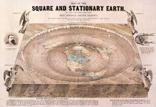

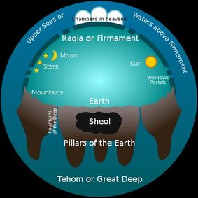
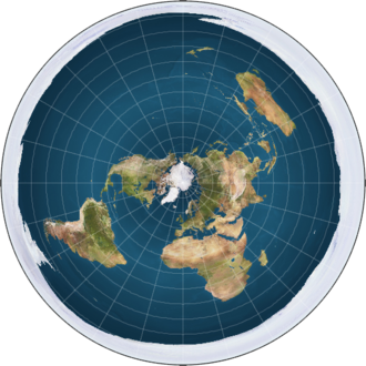
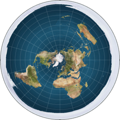


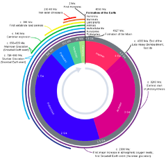
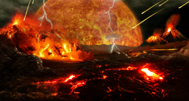


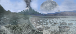
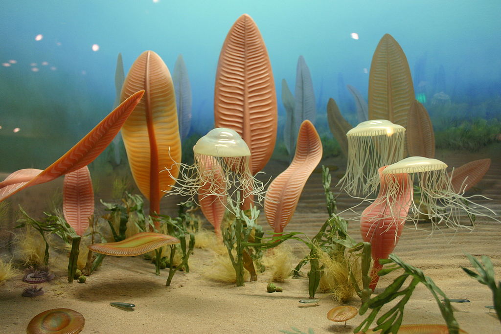

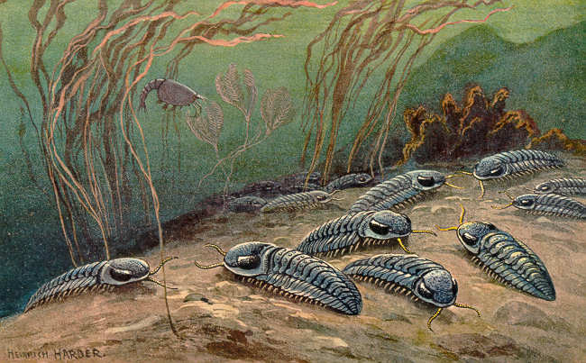


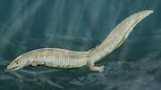
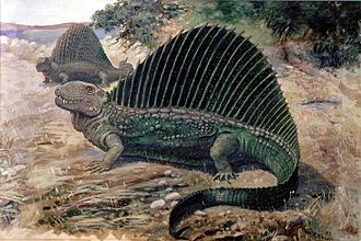
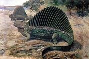

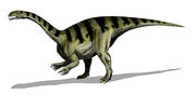


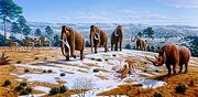


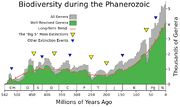

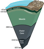


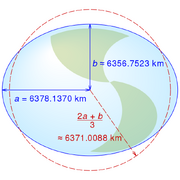

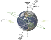

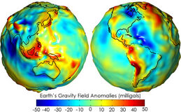

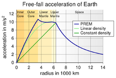

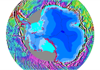
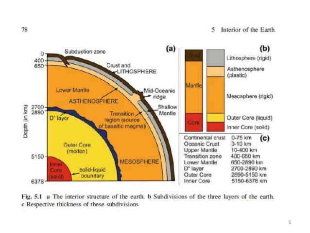
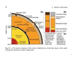

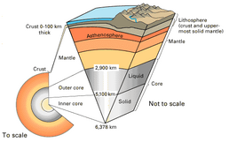
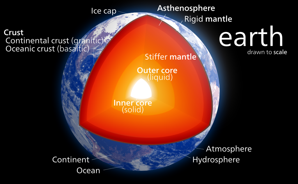
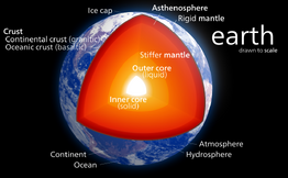
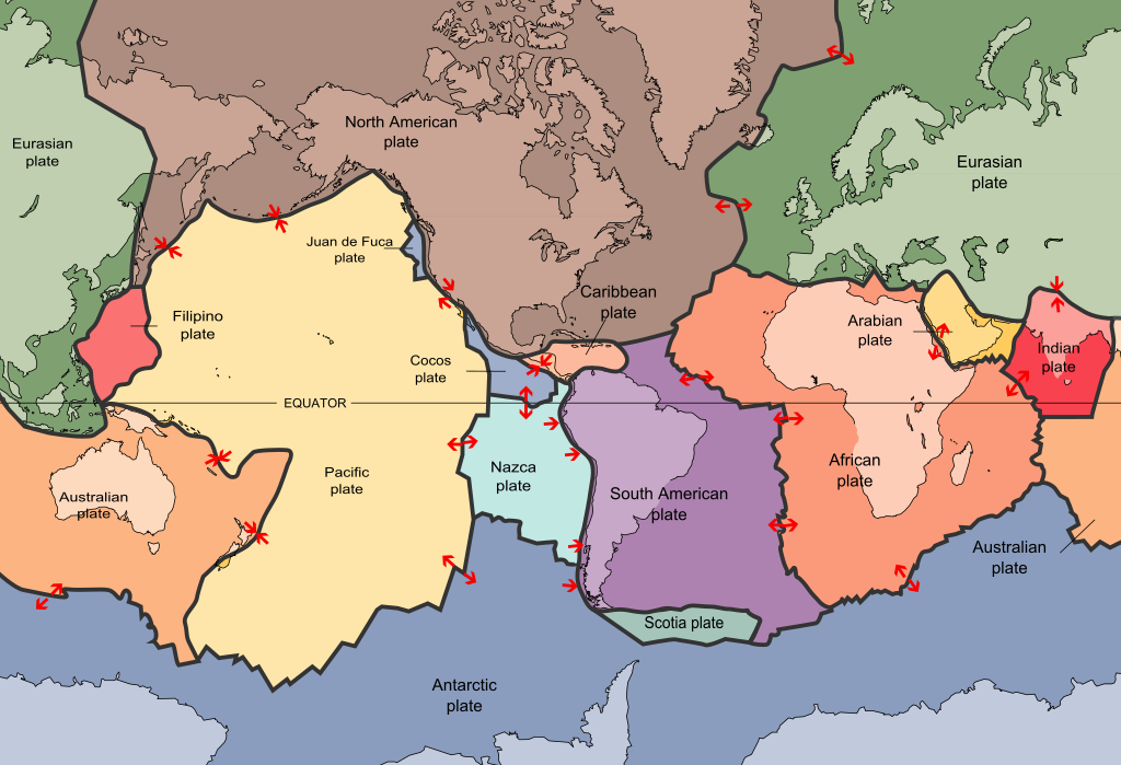
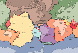


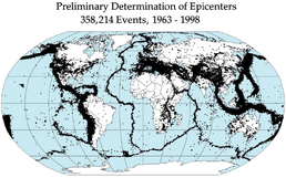
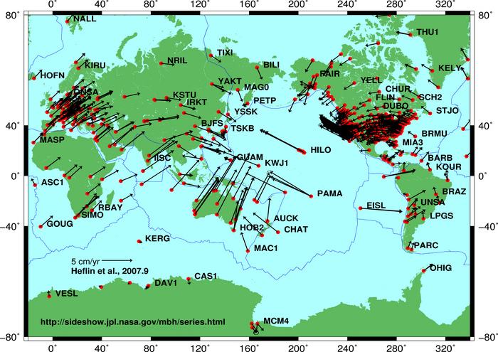
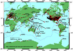


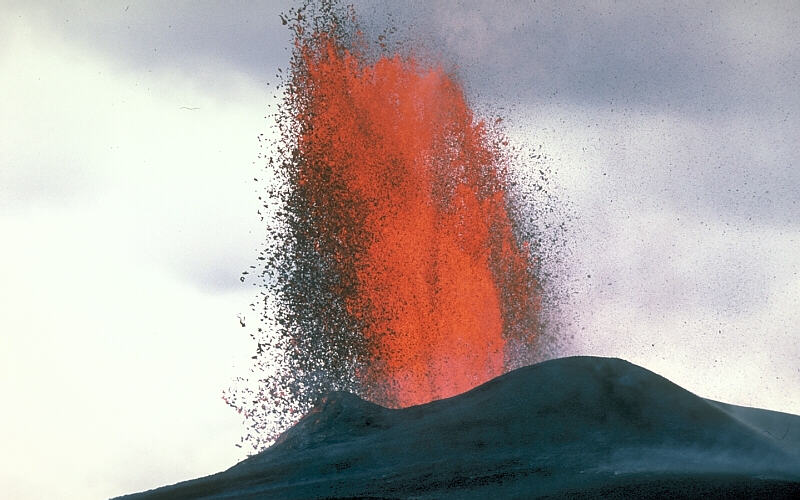


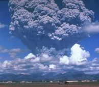
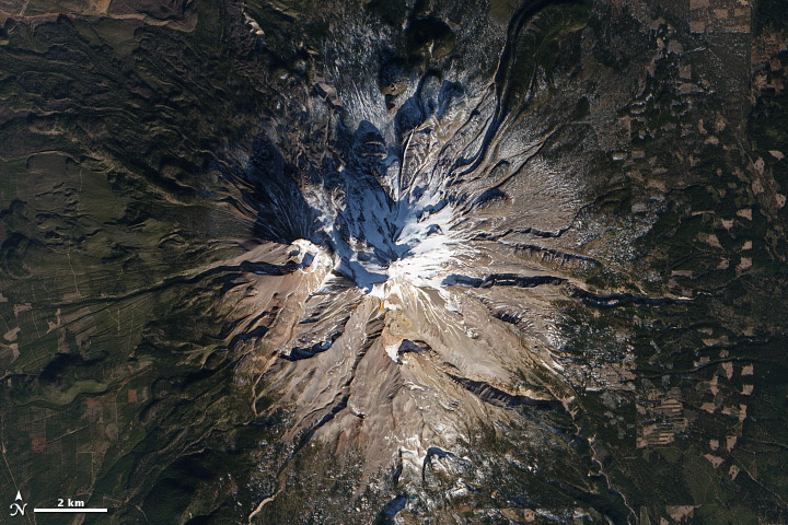


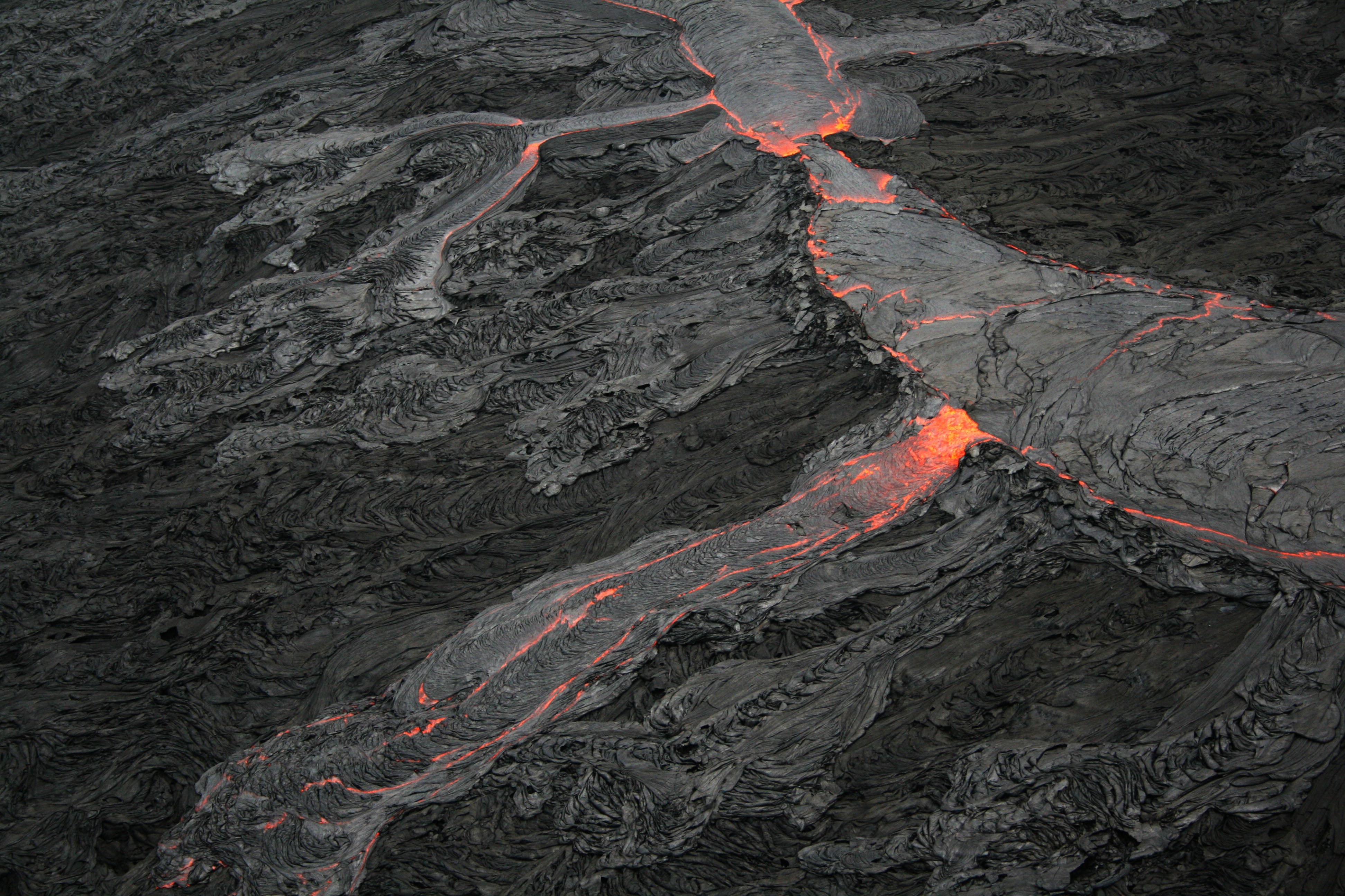


_no_borders.png)

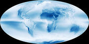
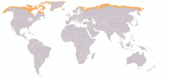

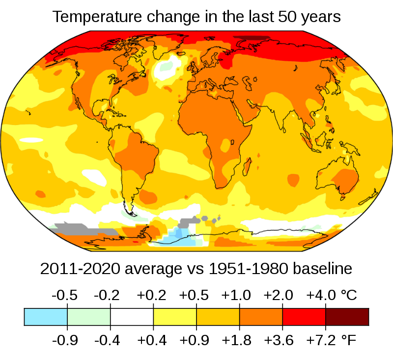
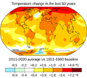
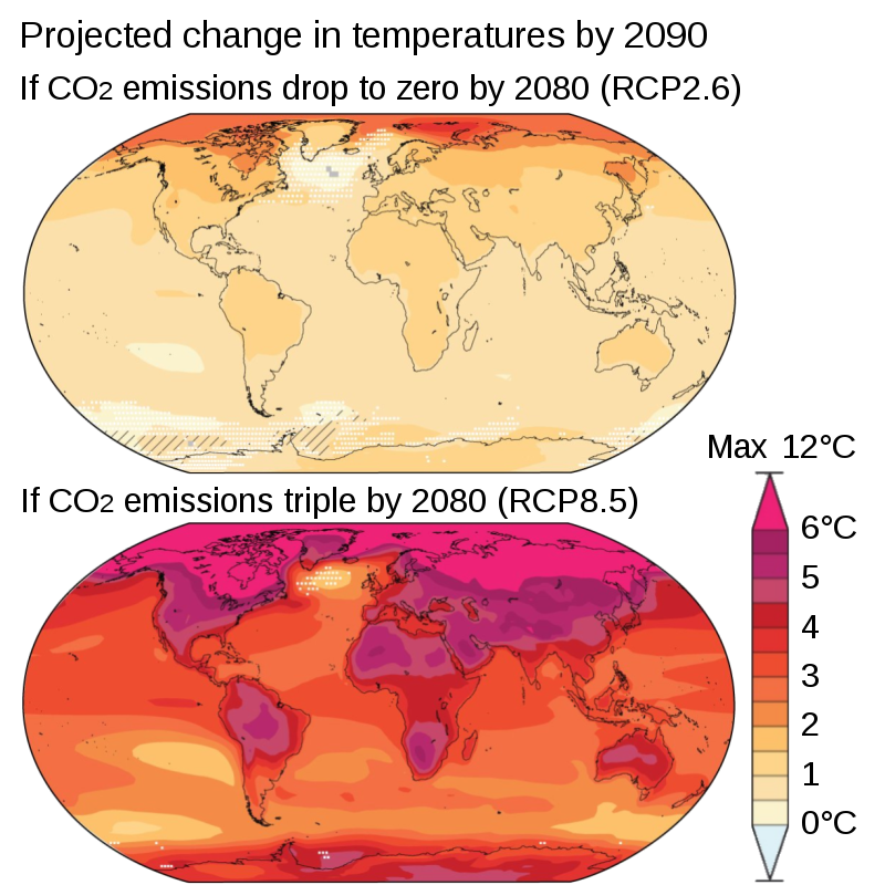
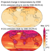

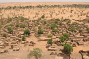
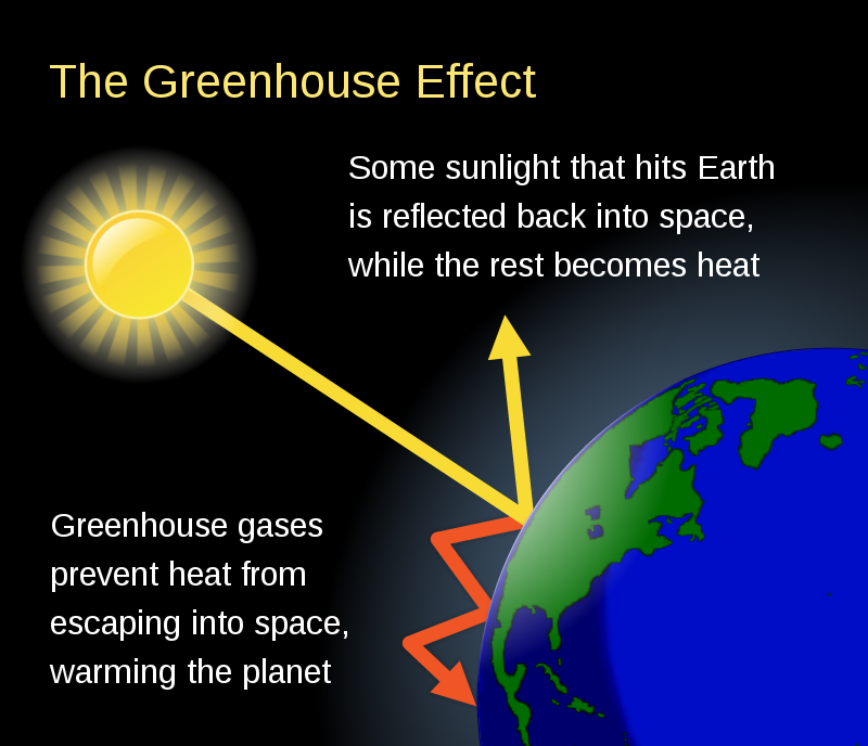


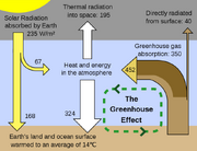

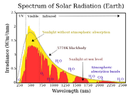


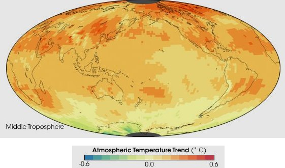

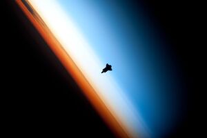

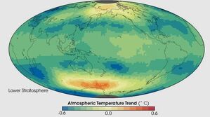


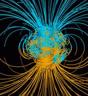

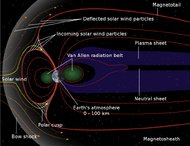


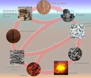
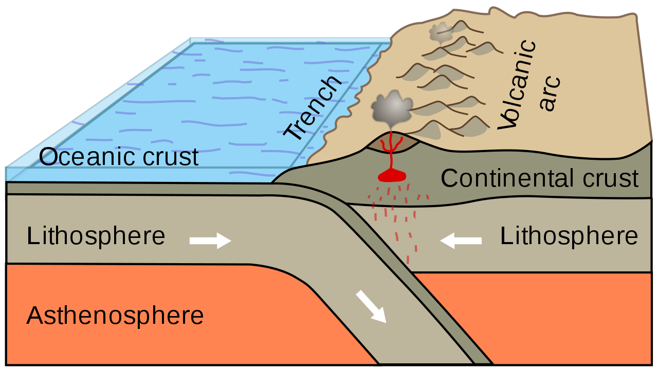


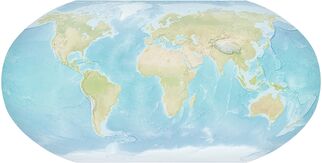

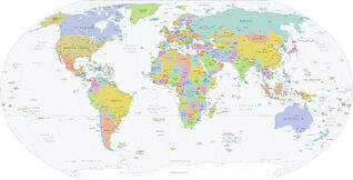


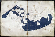


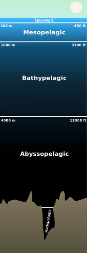

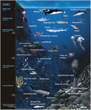
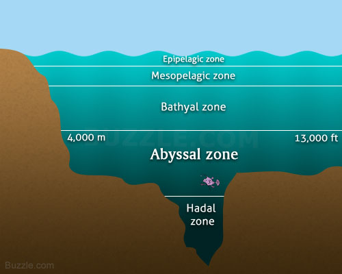
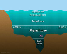


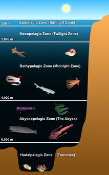


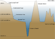
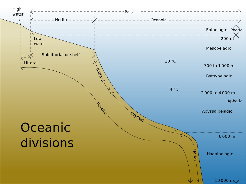
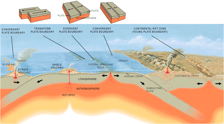
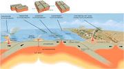
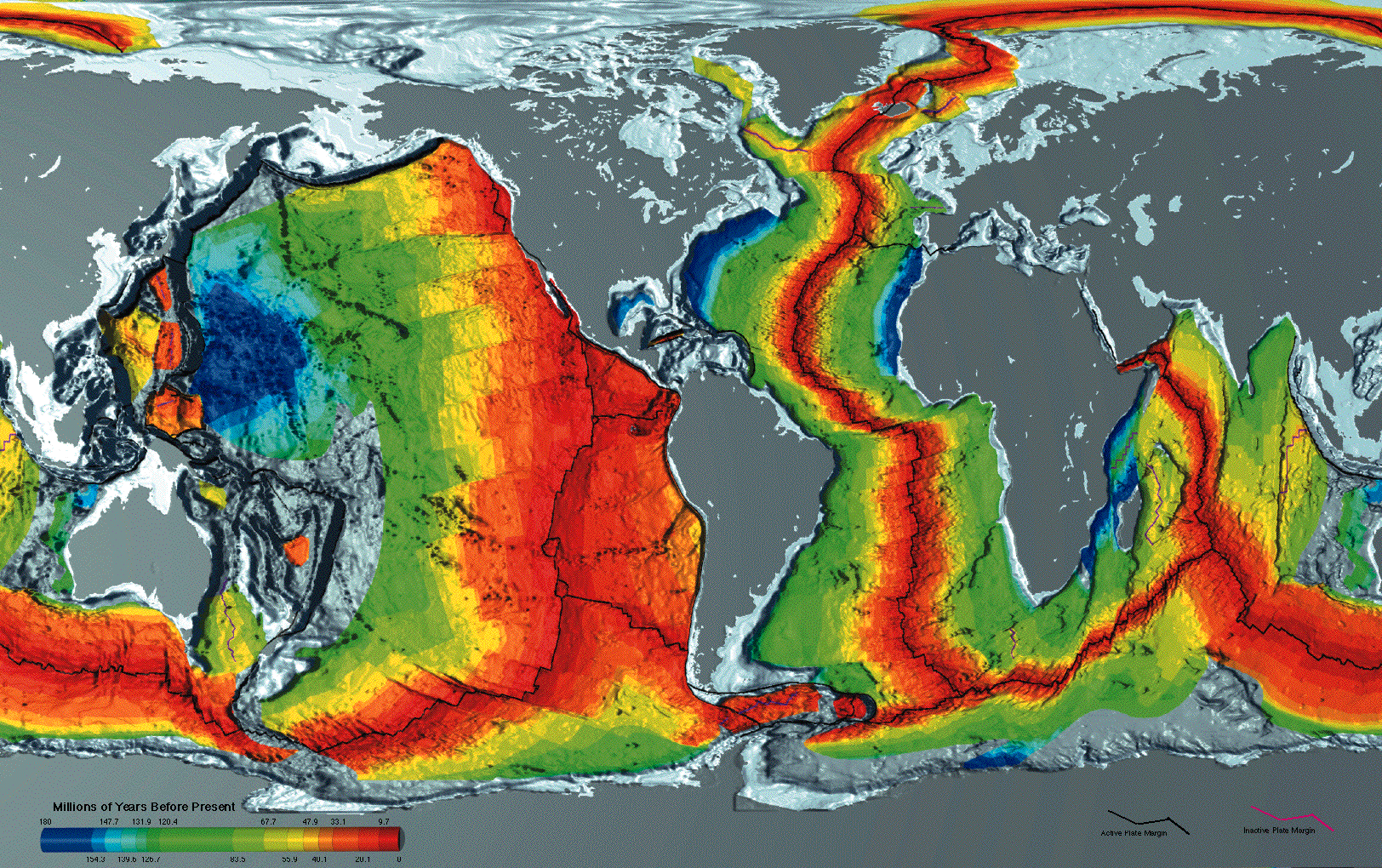


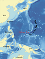

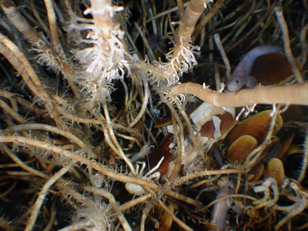


.jpg)


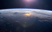

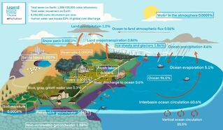
.jpg)
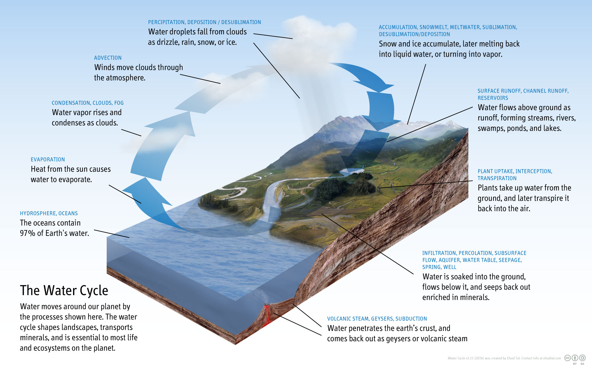

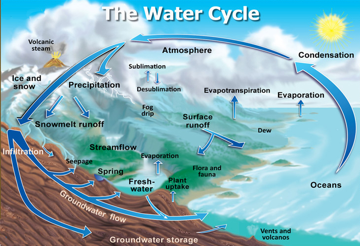
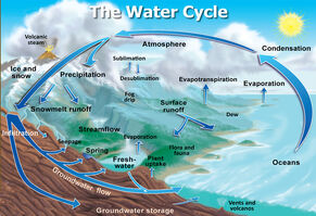
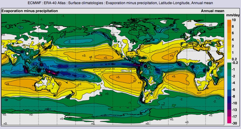


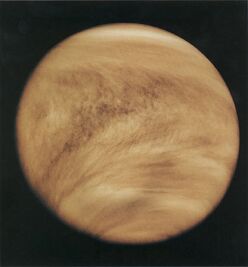


.jpg)
")
")
")
")
")
")